The Presidents of Russia and Ukraine Vladimir Putin and Viktor Yanukovych (establishing boundaries) of the maritime space in the Azov and Black Seas. The signing ceremony took place at the Livadia Palace in Yalta.
Below is some background information.
In 1991, after the collapse of the USSR, Ukraine defined its maritime border along the line of the ravine between the Krasnodar Territory and the island of Tuzla. After this, the navigable part of the Kerch Strait ended up on the Ukrainian side.
"Tuzla" is the name of three geographical entities: Cape Tuzla, Tuzla Island and Tuzla Spit.
Cape Tuzla is the most western point Krasnodar region, located 8 kilometers from the village of Taman.
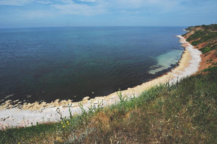
IN early XIX centuries, the island of Tuzla was a spit that protruded into the sea for almost 11 kilometers and was part of the Taman Peninsula. At the beginning of the 20th century, there were about a dozen Cossack farms on the spit. In 1925, a canal was dug at the base of the spit for the passage of fishing boats. After a severe storm that same year, the canal turned into a strait, and soon the width of the strait reached several kilometers. Thus, the spit turned into an island. At the end of the 1940s, an attempt was made unsuccessful attempt restore the braid. In 2003, Russia made a second attempt to restore the Tuzla Spit. But due to a territorial dispute between Ukraine and Russia, the filling of the spit was stopped.
Russian-Ukrainian negotiations by definition legal status Sea of Azov and Kerch Strait and delimitation maritime spaces have been taking place in the Black Sea since 1996.
Ukraine’s position on the maritime border issue is that between the former Soviet republics- RSFSR and Ukraine - there was a certain administrative border in the Kerch Strait. Russia, in turn, notes that in the Soviet Union between union republics along the waters of inland sea waters administrative boundaries were not established, therefore there were and are no legitimate documents of the union or republican level that would fix the demarcation line in the waters of the Sea of Azov and the Kerch Strait.
In this regard, Russia cannot recognize the established Ukrainian side in 1999, unilaterally the so-called “state border security line” in these waters.
On December 15, 1999, by decree of the Government of the Russian Federation, a negotiating group was formed on the legal status of the Azov Sea.
At a meeting of the Russian and Ukrainian delegations in April 2001 in Kyiv, the issue of developing a Declaration or Joint Statement on the legal status of the Sea of Azov and the Kerch Strait and the delimitation of maritime spaces in the Black Sea was considered. Russia and Ukraine agreed to maintain “the status of the Azov-Kerch water area inland waters two states."
The Treaty on the Russian-Ukrainian State Border, signed on January 28, 2003 by the presidents of Russia and Ukraine, defined the land border between the two states. Article 5 of the treaty establishes the status of the Sea of Azov and the Kerch Strait as internal waters of the two countries.
On September 17, 2003, at a meeting between the Presidents of Russia and Ukraine, Vladimir Putin and Leonid Kuchma, issues of final settlement of the legal status of the Sea of Azov and the Kerch Strait were discussed.
The negotiation process intensified after the start of construction of a dam in the Kerch Strait (September 29, 2003).
On November 5, 2003 in Kyiv, during negotiations between the Deputy Ministers of Foreign Affairs of Russia and Ukraine Viktor Kalyuzhny and Alexander Motsik, an agreement was reached to create working groups to address environmental and navigation issues in the Sea of Azov and the Kerch Strait.
On December 24, 2003, the presidents of Russia and Ukraine, at negotiations in Kerch, signed an agreement on cooperation in the use of the Sea of Azov and the Kerch Strait, which notes that the Sea of Azov and the Kerch Strait are historically internal waters of the Russian Federation and Ukraine, but the Sea of Azov is delimited along the line of the state border, and the settlement of issues related to the waters of the Kerch Strait is the subject of further agreements between Ukraine and the Russian Federation. The treaty ensures "free passage of commercial and military ships of the two countries through the straits, ensures freedom of navigation for the ships of both countries." The treaty also states that the Sea of Azov is inland sea two countries, and calling foreign ships it can only be entered into with the consent of both parties. The document also emphasizes that “the settlement of issues related to the waters of the Kerch Strait is carried out by agreement between the parties.” The governments of the two countries are entrusted with the creation of a joint Russian-Ukrainian corporation for the purpose of cooperation in the Azov-Kerch water area, including the operation of the Kerch-Yenikalsky shipping canal. The governments are also instructed to prepare proposals for the restoration and development of ferry services between the two countries across the Kerch Strait for passenger and cargo transportation.
Negotiations on the delimitation (establishment of boundaries) of the maritime border continued.
On July 11, 2012, it became known that Ukraine and Russia completed negotiations on the delimitation of the Azov-Kerch water area.
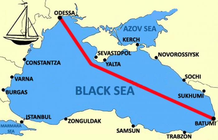
After the annexation of Crimea to Russia, changes occurred maritime boundaries in the Black Sea. As a result of this, most likely, the South Stream gas pipeline will take a different route. In addition, Russia is gaining new opportunities to export its products through the port in Kerch. It will be interesting to get acquainted with the maps of the new borders. In the Black Sea, 12 nautical miles from the coast are the territorial waters of the state, 250 miles constitute a special economic zone. According to the 2003 agreement on the Sea of Azov, the territorial waters of the countries are limited to a 5-kilometer zone, the remaining waters are in joint economic ownership. In addition to this, you can also look at the project of a new bridge connecting Taman Peninsula with Crimea. The Greeks called the Kerch Strait the Cimmerian Bosphorus, but the Greeks called the strait separating Asia Minor from the Balkan Peninsula the Thracian Bosphorus.
P.S. I think few people know that the legendary Colchis of the Argonauts was not located in swampy Georgia, as some philologists naively believe, but... on the banks of the Thracian Bosphorus (“Bull Passage”). The ships of the ancient Achaeans were called beads ("bulls") or minotaurs ("bulls of Minos") - that's why this strait was so named, sometimes sea ships The Achaeans called them hippocamps (“sea horses”), so on their noses there were images of either the head of a bull or the head of a seahorse. The ancient Greeks called the Black Sea the Pontus Euxine (“Hospitable Sea”), and the Phoenicians called the North Sea (“Ashkenas”). But we will turn to Colchis after a careful study of the path of the Argonauts, which was the Golden Fleece - the goal of their journey...
1.Borders of Russia and other countries in the Black Sea before the annexation of Crimea
2. Borders of Russia and other countries in the Black Sea after the annexation of Crimea
3. Oil and gas fields in the basin of the Black and Azov seas and land  4. Kerch Strait and crossings from mainland Russia to Crimea
  5. The border in the Black Sea between Ukraine and Romania after the decision International Court of Justice UN on February 3, 2009, when 79.4% of the disputed oil and gas shelf territories were transferred to Romania
The geographical position of the Black Sea is probably known to every resident of our country. Why? The thing is that almost all of us have been to its coast at least once in our lives, or are planning to go there on our next vacation.
A map of the Russian Black Sea shows that our country shares it with Ukraine, Georgia, Turkey, Bulgaria and Romania.
About location, history, climate and characteristic features this section of the world's oceans and we'll talk in this article.
Section 1. General information
If you look at the Black Sea on the world map, you can be sure that it belongs to the basin Atlantic Ocean and refers to internal type seas. Its area is approximately 422.0 thousand square meters. km (according to other sources - 436.4 thousand sq. km).
Visually, the sea resembles an oval shape with the longest axis being 1150 km. The maximum length from north to south is 580 km. The average depth is 1240 m, and the greatest depth is 2210 m.
The ports of the Black Sea have a number of advantages, since the waters of this section of the world ocean are connected with the Marmara Strait through the Bosporus Strait, then, through the Dardanelles Strait (Hellespont) - with the Mediterranean and Aegean, and the Kerch Strait - with the Azov Sea.
The border line between Europe and the Crimean peninsula juts deep into the northern part of the sea runs through its waters.
Its waters wash the territories of several states at once: Russia, Ukraine, Georgia, Romania, Turkey and Bulgaria. In the north-east of the coast there is partly recognized state Abkhazia.
The sea basin has a rare property. Its lower layers are filled with hydrogen sulfide, which is why there is no life at a depth of over 150 m (with the exception of individual species bacteria).
The geographical location of the Black Sea is very favorable. Why? The thing is that it has the most important economic, transport, strategic and military significance, and is also one of the largest recreational areas Eurasia. The main military bases of the Russian Black Sea Fleet are concentrated in the ports of Sevastopol and Novorossiysk.
Section 2. History of the Black Sea
Photos of the Black Sea, as a rule, attract attention, captivating with their beauty and certain limitlessness. But what do we really know about him?
First of all, it is impossible not to mention that this is a relatively young sea, which has an unformed ecosystem that continues to develop: the water level changes, new representatives of flora and fauna appear, and some disappear.
In the past, which was about 8 thousand years ago, this sea was actually a lake. His biosystem is highly susceptible external influences- influence of climate or person. Despite the fact that it is much less ocean and life there is less diverse, the Black Sea coast and its ecology are of interest to scientists.
Section 3. What is the climate of the element?
The climate of the Black Sea region is due to its mid-continental location and mainly relates to continental type. This region is characterized by warm, wet winters and dry summers. and the Caucasian coast are protected from the winds by mountains, giving it a Mediterranean subtropical climate.
The geographical position of the Black Sea is such that weather Atlantic cyclones have a significant impact, bringing storms and cold temperatures. Winds from the southwest usually bring humid Mediterranean air masses.
In January it stays in the north average temperature up to +2°C, but it gets cold down to -5°C, and snow falls periodically. It is much warmer in the south and the Caucasus. It rarely drops below +5°C here.
July air temperature in the north of the sea averages +25 -+27 °C. Thanks to the sea, the air temperature usually does not rise above 37°C.
The warmest corner of the Black Sea region is the Caucasus coast, where the average is +17°C per year. The Caucasian coast receives the most precipitation (1500 mm per year), with the least in the north-west (up to 300 mm per year).
The Black Sea is not subject to freezing; the water does not cool below +8 °C.
Section 4. Local flora and fauna

Have you ever wondered what kind of organisms inhabit the Black Sea? The characteristics show that the flora of the Black Sea consists of more than 260 species of green, red bottom and brown algae: Cladophora, Ulva, Cystoseira, Zoster, etc.
Sea phytoplankton includes about 600 species, among which are diatoms and representatives of dinoflagellates (Dinophysis, Alexandrium, Protoperidinium).
The fauna is less diverse compared to, for example, the Mediterranean. In the waters of this sea 2,500 species of animals live, including 160 species of mammals and fish, up to 500 protozoa, 500 crustaceans, 200 mollusks, as well as other invertebrates. In the Mediterranean today there are approximately 9,000 species.
At the bottom of the sea, oysters and mussels, predator mollusks of rapana found refuge. Among the coastal rocks and stones you can find crabs, jellyfish, shrimp, sea anemones and sponges.
The small number of fauna is affected by the salinity and temperature of the water, as well as the formation of hydrogen sulfide at depths. However, the sea waters are suitable for the existence of unpretentious species that do not require depth.
Section 5. What kind of resorts are located on the Black Sea?

Russian resorts are located in the Krasnodar region. The most popular of them are Sochi, Anapa, Gelendzhik and Tuapse. The best sanatoriums and boarding houses have been built here.
The following resorts are located on the Crimean peninsula: Evpatoria, Alushta, Yalta, Sudak, Feodosiya, Chernomorskoe and Sokolinoe. The health resorts of Abkhazia are a paradise for relaxation. One of the major tourist centers of Ukraine is Odessa, which has become one of the last years a real pearl by the sea.
Sochi
Have you decided to go to the Black Sea? Reviews from travelers unanimously state that it is really impossible not to visit here, and there are actually many prerequisites for this.
First of all, we note that Sochi is the southernmost and warmest resort in Russia. And it is here, on the coast, that dozens of boarding houses and sanatoriums are located.
The beach season in Sochi lasts from May to mid-October. The weather is sunny 300 days a year. Favorable mineral springs and mud have a healing and healing effect on humans. The sanatoriums welcome visitors throughout the year.
The nature of this region is unique and inimitable: mountain gorges with wild rivers, waterfalls and caves, cold lakes, impenetrable forests and high-mountain ski slopes. These places attract lovers active rest and extreme.
Sochi is famous not only for its beach holidays, but also for its cultural attractions. There are many museums, theaters, entertainment centers, restaurants and nightclubs.
Yalta
One of the most famous resort cities of Crimea is Yalta. In addition, he is one of the most beautiful cities peace.
This modern resort an amazing place called the Black Sea. The map shows that the beaches here are actually huge, 72 km long.
The city is considered the capital of all Crimean resorts and an important administrative, cultural and tourist center on the southern coast of Crimea.
Abundance of sun and vegetation, warm sea and sand, fresh air, mountains and a huge number of attractions create favorable conditions for relaxation and recovery.
Abkhazia
In fact, it seems that God himself created these places for man to rest. The beach season lasts from May to October and you can enjoy the sun 220 days a year.
Sea water is low in salt, clear and ideal for swimming. Tourist Abkhazia is home to hospitable people, luxurious nature and many historical monuments.
Guests can enjoy excursions to waterfalls, mineral springs and Lake Ritsa, karst caves and the ruins of an ancient city. The famous resorts of the region are Pitsunda, Gagra, Sukhum and Gudauta.
The tourism industry of Abkhazia is developing rapidly: old boarding houses have been renovated and new comfortable hotels have been built, there are many restaurants and entertainment centers on the streets. One of the popular resort places is the city of Pitsunda, which is surrounded by pine forests, which create a special microclimate with a healing pine aroma.
It is fresh and cool here even in hot weather. All boarding houses are located in a picturesque bay near the sea.
Section 6. Movement of water in the Black Sea
It is believed that the Black Sea ports have many advantages. Let's explain why. Usually this part of the world's oceans is quiet and calm. Waves appear in windy weather, most often in winter. Their height can reach 15 m, which is dangerous only for small ships. The ebb and flow of the tides does not exceed 10 cm and is almost invisible.
In general, there are two types of currents in the sea - surface and double. The former are caused by cyclonic winds, while the latter are formed in the Bosphorus and Kerch Straits and are caused by the difference in water density in the two basins.
Currents surface type form two closed rings. The western ring narrows to the south and is approximately 100 km wide opposite the Danube delta. The speed of this current is almost 0.5 km/h. The Eastern Ring reaches 50-100 km and has a speed of up to 1 km/h.
The double current in the Bosphorus arises due to water exchange between the Black and Marmara seas. The lighter and less salty water of the Black Sea enters Mramornoe at a speed of up to 2 km, and in return receives more salt water Sea of Marmara.
Another double current is formed between the Black and Azov seas. At the same time, the desalinated water of the Azov Sea flows upstream into the Black Sea, receiving in return more salty water.
In addition to horizontal currents, there are vertical, limited top layers water (up to 80 m).
Section 7. Sea threats: winds and fogs
The geographical position of the Black Sea clearly indicates that fogs occur over the coast or coastal areas mainly in the cold season. When cold sea air invades land, fog forms over the sea near the coast.
On the coast it usually appears in the spring. Largest Nebula observed in winter, especially in the Bosphorus Strait (up to 80 days a year). However, there are prolonged fogs. For example, in winter in Odessa they last up to 10 days. Photos of the Black Sea taken in such weather are particularly romantic and mysterious.
The strength and speed of the wind at sea is greater than on the coast. When cyclones appear over the sea, moist air becomes vertically unstable, forming vortex winds and tornadoes, dangerous for small ships. Wind speed in winter reaches from 3 to 40 m/sec. Sometimes there are storms. Night winds bring coolness to the coast.
Section 8. Why are Black Sea currents dangerous?

However, the Black Sea can also be treacherous and merciless; the characteristics of this part of the world's oceans clearly indicate the existence of a changeable current here, directed counterclockwise along the entire perimeter.
The current forms two rings called “Knipovich glasses” (in honor of the hydrologist who described this phenomenon). The speed of movement depends on the rotation of the Earth. Also, the change in current is influenced by the force and Sometimes eddies appear in coastal zones directed against the main current (anticyclonic gyres).
The movement of upper alongshore currents is variable and determined by the wind. One of these currents is called a draft, which forms during a storm. Waves rushing onto the shore retreat in powerful streams along the channels formed on the sandy bottom. Such currents are very dangerous for people and can carry them far from the shore. To get out of them, you need to swim to the shore not in a straight line, but diagonally.
Section 9. Why is the sea rough? Ancient legend
The Black Sea is clearly visible on the world map, even on the most ancient one. That is why, apparently, they have known about him for quite a long time, creating myths and retelling epics. And here is one of them.
In ancient times there lived one brave hero, about whose bravery legends were written. One day an old magician decided to give him a magic arrow, whose Magic force depended on the intentions of the person. If it fell into the hands of a villain, it could bring a lot of misfortune on earth. The hero never used it unnecessarily and for selfish purposes. Having grown old, he began to look for a person who could be trusted with an arrow. But only a worthy owner could reveal her secret.
Then the hero decided to hide the weapon in the Black Sea and asked his sons to take her to the very middle of it. He knew that they would not carry out his order the first time, and he sent them again. The sons fulfilled the will of their father and lowered the arrow to the bottom of the sea. This angered the sea, it began to make noise and to this day is trying to throw the arrow ashore.
Section 10. Is the Black Sea getting warmer?
Can you tell exactly where the Black Sea is? The map shows that it should be considered the southernmost maritime border of our state. And, of course, it is also the warmest. However, there is an opinion that the temperature there is gradually increasing. Is it really?
Black Sea ( Krasnodar region taken as the basis for the study) is filled with hydrogen sulfide, which means that only coastal and surface layers of water are suitable for life. By the way, because of this it is one of the most sparsely inhabited seas in the world.
Also, the sea ecosystem is negatively affected by global warming, which has led to increased air temperatures in winter and incomplete cooling of the upper layers of the sea. And this, in turn, complicates the process of vertical rotation of the upper layers of water to depth to maintain the boundaries of hydrogen sulfide.
Warming has led to the fact that the hydrogen sulfide zone has risen to the surface of the sea by almost 12 meters and these waters have become lifeless. The volume of water enriched with oxygen continues to decrease, which raises concerns among environmentalists. This means the Black Sea, whose coordinates are 43°17′49″ N. w. 34°01′46″ E. Most likely, it will continue to warm up.
The recent statement by Ukrainian President Petro Poroshenko that he is going to return Crimea, now with the help of reviving the naval forces of the “Independence”, caused bewilderment among many naval commanders: either to laugh, or to stop reacting to all sorts of bureaucratic nonsense.But the situation worsened even more when Poroshenko announced in Odessa a plan for the development and implementation of the State target program development of shipbuilding for the period until 2035. And he added that one of the most important tasks considers ensuring security and defense capability in the Azov-Black Sea region.
Agree that such a presidential statement is quite funny. After all, during the entire period of independence, Ukraine itself, in Nikolaev in 2011, laid down only one more or less modern warship - the Project 58250 corvette Volodymyr the Great. According to Ukrainian data, only 43% of the ship is on the slipway today.
Let us remind you that during the USSR they built aircraft-carrying cruisers, compared to which the Ukrainian corvette with a displacement of 2650 tons is a small armored boat. “Nezalezhnaya” shamefully lost the majority of the Navy in March 2014. Then many ships raised St. Andrew's flags and went over to the Russian side. And Kyiv was left with only half of its warships, which were relocated to Odessa. Some were even towed; all the ships were long outdated, including the flagship, the frigate Hetman Sahaidachny. Only one Project 206MR missile boat is armed with outdated P-15M Termit anti-ship missiles. Recently, one of the boats in its territorial waters was blown up by an alleged World War II naval mine. And the only naval educational institution- The Academy of Naval Forces named after P. S. Nakhimov has already moved to Russian Sevastopol.
It is clear even to a non-specialist that Poroshenko’s “sea” statement is empty demagoguery. Goal: to improve the ratings of Ukrainian sailors, while at the same time pleasing their own revenge seekers. And no one has canceled the traditional “cutting” yet. It is possible that over the next 10-15 years, Ukraine will be able to build 2-3 Project 58250 corvettes armed with French Exocet anti-ship missiles. But compared to the Russian Black Sea Fleet, this is less than a drop in the bucket. In a hypothetical military clash, the Ukrainian fleet would be instantly completely destroyed using various naval missiles, including land-based Bastion. So what kind of “return” of Crimea to Ukraine with the help of the fleet can we talk about?
However there are more interesting problem, about which everyone is still silent. It's about on new maritime borders in the Sea of Azov and access to its waters. Let us recall that the last statement on the delimitation of maritime boundaries in the Azov and Black Seas was signed in 2012 by Vladimir Putin and Viktor Yanukovych. But final decision it was never accepted.
There was conditional boundary, quite controversial, passing through the Kerch Strait. But after Crimea became part of Russia, all talk about resolving this issue, of course, stopped. Although there are still no official maritime borders there, it is clear that the entire Kerch Strait remained with Russia, as did the section of the Sea of Azov adjacent to the shores of Crimea. The Crimean section of the Black Sea is also lost for Ukraine. The passage of ships from the Sea of Azov to the Black Sea and back without permission from Russia is legally impossible. Concerning Ukrainian borders in the Sea of Azov - then they can conditionally be considered a 12-mile (22-kilometer) coastal zone (as a rule, this is how state boundaries are determined in any seas and oceans).
Accordingly, only warships of the Russian Black Sea Fleet have access to the Sea of Azov. Only a small number of boats are based in the ports of Mariupol and Berdyansk. Kyiv is now able to control only the coastal zone of the Azov Sea from settlement Shirokino to Strelkovoe (in Crimea this is the border between Ukraine and Russia). Plot coastal zone from Russian border(Novoazovsk) to Shirokino is under the control of Donetsk people's republic. Experts believe that the Ukrainian fleet in the Sea of Azov is only capable of fighting reconnaissance groups of militias, and then with varying degrees of success.
It must be said that there is uncertainty with the western coast of Crimea. The distance from the coast of the peninsula to the coast of Ukraine here ranges from 15 to 40 kilometers. It turns out that countries simply do not have enough space to create a 22-kilometer zone of territorial waters. In addition, it is in this area that several oil-rich shelves have been found. In such cases, it is customary to determine the border along the midline. But today relations between our countries do not contribute in any way to constructive negotiations. And they will not begin until Ukraine recognizes the annexation of Crimea to Russia. However, local exacerbations can be provoked.
So is there any threat to Russia from the Ukrainian Navy? The land admirals of Kyiv have nothing to cover: the waters of the Russian part of the Sea of Azov are completely controlled by boats, and often by larger ships of the Russian Black Sea Fleet. Russian naval aviation also participates in patrolling. And any target in the Sea of Azov can be hit by an anti-ship missile from the Crimea or from Black Sea Fleet ships, which can be fired from the Black Sea.
Of course you can send to Once again messengers to Washington to request military assistance already along the naval line. Many US ports are clogged with decommissioned destroyers. You can also put a mothballed old battleship under steam. But how long will it take until Ukrainian sailors master this technique? Newest ships The Pentagon is unlikely to send to this area, which could become "hot" due to the sick imagination of some high-ranking officials. I would like to remind them of the statement Russian President Vladimir Putin made at last year’s meeting in Novorossiysk. There he announced the deployment of new Russian sea-launched cruise missiles that would "nullify" American power and negate Washington's military superiority in a vast geopolitical region from Warsaw to Kabul, from Rome to Baghdad.
To sum up, we can say that all the talk about the revival of the Ukrainian Navy will remain talk. No fighting or material resources there is no need for this now, and there is no foreseeable future. There is no normal infrastructure for the navy. Yes, and with personnel it’s about to arise urgent problem: There is nowhere to train new sailors, and many of the existing ones are now serving in the RF Armed Forces. And how or who will Kyiv threaten the security of the Republic of Crimea?
As for the delimitation of maritime borders with Ukraine, after the annexation of Crimea to Russia, this issue seemed to be settled. The main controversial issue related to the borders in the Kerch Strait has now lost its relevance. But it arose new problem with delimitation of borders on the western coast of Crimea.
The "Nezalezhnaya" fleet now has no access to the Sea of Azov. In a military sense, this sea is lost for Ukraine. Only patrol boats located in Azov ports can display the “yellow-blakit” flag. And few serious politicians are paying attention to the irresponsible statements of Kyiv leaders.
Vladimir Bogdanov
Photo: Alexey Pavlishak/TASS
Tikhonova S.N., graduate student of the Department of Administrative and International Law of Moscow Border Institute FSB of Russia.
The collapse of the USSR and the formation of new ones on its territory independent states gave rise to a number of problems related to the legal status and regime of use of certain categories of maritime spaces in the Black Sea-Azov basin, as well as their delimitation. In particular, these include issues of the legal status and regime of use of the Sea of Azov and the Kerch Strait<1>.
<1>See: Shemyakin A.N. Modern international maritime law and prospects for its development. Odessa: ONMA, 2003. pp. 104 - 109.
In the Concept of forming a system for ensuring the interests of the Russian Federation in the border area (approved by the decision of the State Border Commission of January 28, 2005) in Part 1 of Chapter. V indicates that " important direction the formation of a system for ensuring the interests of the Russian Federation in the border area is to solve the problems of territorial delimitation of the Russian Federation with neighboring states and complete the international legal formalization of the State border along its entire length"<2>.
<2>The concept of forming a system for ensuring the interests of the Russian Federation in the border area. M.: Granitsa, 2005. P. 18.
It is obvious that the concept of “state border” is of core importance for all border activities, which should predetermine the meaning and content of these activities, and among the federal laws that mediate border activities, the Law of the Russian Federation of April 1, 1993 N 4730 is of paramount importance. -1 “On the State Border of the Russian Federation” (hereinafter referred to as the Border Law)<3>. Based on Art. 1 of the Border Law The state border of the Russian Federation is a line and a vertical surface passing along this line that defines the limits state territory(land, water, subsoil and airspace) of the Russian Federation, i.e. spatial limit of the state sovereignty of the Russian Federation.
<3>Gazette of the Congress people's deputies Russian Federation and Supreme Council Russian Federation. 1993. N 17. Art. 594.
It should be recalled that on the basis of Art. 4 (Part 1) of the Constitution of the Russian Federation, the sovereignty of the Russian Federation extends to its entire territory.
Meanwhile, the question arises about the compliance of the provisions of Art. 1 of the Law on the Border to the norms of international law, the Constitution of the Russian Federation and realities today. The definition of the territory of Russia is contained in Art. 67 (part 1) of the Constitution of the Russian Federation, which states that it includes the territories of the constituent entities of the Russian Federation, internal waters and the territorial sea, air space above them.
In accordance with Part 1 of Art. 1 Agreements between Russian Federation and Ukraine on cooperation in the use of the Sea of Azov and the Kerch Strait, signed in the city of Kerch on December 24, 2003.<4>, the Sea of Azov and the Kerch Strait are recognized as internal waters of Russia and Ukraine. Federal law dated April 22, 2004 N 23-FZ "On ratification of the Treaty between the Russian Federation and Ukraine on cooperation in the use of the Sea of Azov and the Kerch Strait"<5>the said international treaty was ratified and became integral part legal system Russia. According to paragraph 1 of Art. 2 United Nations Convention on the Law of the Sea 1982<6>the state has sovereignty over its internal waters. Thus, in the Sea of Azov and the Kerch Strait a legal situation has developed where there is no state border, but Russia has sovereignty<7>.
<4>Bulletin of International Treaties. 2004. N 7. S. 46 - 47.
<5>Collection of legislation of the Russian Federation. 2004. N 17. Art. 1590.
<6>
<7>See: Pronichev V.E. Legal basis strategic development of the border service // Law and Security. 2005. N 4(17). pp. 11 - 28.
What is the background to this problem?
The Sea of Azov due to its geographical location and, in accordance with the norms of international maritime law, had the status of internal waters of the USSR. It must be taken into account that geographically the Kerch Strait is an integral part of the Sea of Azov. The smallest width of the Kerch Strait is about 2 miles, which was the determining factor for declaring the waters of the Sea of Azov, in accordance with the norms of international maritime law, as internal waters of the USSR.
The formation of two sovereign states - the Russian Federation and Ukraine - changed the legal status of the Sea of Azov and the Kerch Strait. Its definition is currently the prerogative of Russia and Ukraine.
The Kerch Strait, washing the shores of the Krasnodar Territory and Crimea, is 22 nautical miles (40.7 km) long and has two shipping routes suitable for the passage of ships from the Black Sea to the Azov Sea:
b) fairways No. 50 and 52 are suitable for the passage of ships with a draft of up to 3 m.
The canal was built by Russia in 1874, its length at that time was 18.9 miles. Currently it is the main shipping route of the Kerch Strait.
In connection with the demise of the USSR and the formation of independent states - Russia and Ukraine, the latter unilaterally transferred the Kerch-Yenikalsky Canal under its jurisdiction and controls the movement of ships in the strait.
Thus, a practice has developed when the Russian side controls the movement of the fleet along fairways No. 50 and 52, and the Ukrainian side controls the movement of the fleet along the Kerch-Yenikalsky Canal<8>.
<8>See: Kolodkin A.L., Gutsulyak V.N., Bobrova Yu.V. World Ocean. International legal regime. Main problems. M.: Statute, 2007. P. 242.
It should also be noted that the status of the waters of the Sea of Azov has features that are reflected in the specific application of the provisions of the legislation of the Russian Federation in this water area.
As noted, historically the waters of the Azov Sea had the status of internal waters of the USSR and were located towards the coast from the straight baseline drawn in the Black Sea between the capes of Zhelezny Rog (Russia, Krasnodar Territory) and Kyz-Aul (Ukraine, Crimea). The position of this baseline was announced by the Resolutions of the Council of Ministers of the USSR of February 7, 1984 and January 15, 1985 and was not subsequently changed. Currently, in accordance with the Federal Law of July 31, 1998 N 155-FZ "On Internal Sea Waters, the Territorial Sea and the Contiguous Zone of the Russian Federation"<9>(hereinafter referred to as the Law on the Territorial Sea) part of this line is used to measure the width of the territorial sea of the Russian Federation in the Black Sea.
<9>Collection of legislation of the Russian Federation. 1998. N 31. Art. 3833.
USSR Law of November 24, 1982 "On the State Border of the USSR"<10>, which regulated the legal regime of internal waters of the USSR, did not categorize internal waters as internal sea and internal continental. This practice did not contradict the provisions of the 1982 UN Convention on the Law of the Sea (hereinafter referred to as the Convention).
<10>Gazette of the USSR Armed Forces. 1982. N 48. Art. 891.
It should be noted that the Convention is an international treaty to which the Russian Federation has been a party since 1997. The Convention states that “the waters located offshore from the baseline of the territorial sea constitute part of the internal waters of the State.”<11>, and these waters are subject to the sovereignty of the coastal state. The Convention does not establish rules regarding the delimitation of these waters between riparian states.
<11>Bulletin of International Treaties. 1998. N 1. S. 3 - 168.
With the entry into force of the Territorial Sea Law in Russian legislation a clear definition appeared of which waters belong to “internal sea waters” as an integral part of the internal waters of the state, which are subject to the sovereignty of the state, as well as the provisions of international maritime law. Thus, the term “inland waters” is general and universal. This provision also applies to the waters of the Sea of Azov.
The issue of delimiting maritime spaces between Russia and Ukraine was initiated in October 1995, when Ukraine, in a note addressed to the Russian Foreign Ministry, proposed concluding agreements on the legal status of the Sea of Azov and navigation in its waters and on the legal status of the Kerch Strait<12>. In addition, on October 16, 1995, the Ministry of Foreign Affairs of Ukraine sent a note to the Russian Ministry of Foreign Affairs, which stated: “The Ukrainian Side proposes to make concrete practical efforts to jointly formalize the state border between Ukraine and the Russian Federation. In case of further delay, Ukraine will face forced the need to take unilateral measures to delimit its border with the Russian Federation..."<13>.
<12>See: International legal registration of the State border of the Russian Federation: Information and reference collection. Issue No. 1 (general data) / Under general. ed. Lieutenant General A.L. Manilova. M.: Granitsa, 1997. P. 75.
<13>International legal registration of the State border of the Russian Federation: Information and reference collection. Issue No. 1 (general data) / Under general. ed. Lieutenant General A.L. Manilova. M.: Granitsa, 1997. P. 74.
In October 1995 - January 1996, the interested ministries and departments agreed on Russia's position on the international legal formalization of the border with Ukraine. This position included: securing the status of the historical sea of Russia and Ukraine for the Sea of Azov and the Kerch Strait; preventing the delimitation and establishment of any special zones; sharing and protection; freedom of navigation of all ships flying the flag of the Russian Federation and Ukraine; preventing the entry of warships, research and fishing vessels of third countries; introduction of restrictions on the navigation of non-military ships of third countries; shared resource management and conservation; joint protection and conservation of the marine environment.
The prepared position of the Russian Foreign Ministry was reported to the Government and the President of the Russian Federation.
In addition, on December 19, 1995, the Federal Border Service of the Russian Federation (hereinafter referred to as the FBS of Russia) sent to the Ministry of Foreign Affairs of the Russian Federation, the Ministry of Defense of the Russian Federation, the Ministry of Security environment And natural resources Russian Federation (Ministry of Natural Resources of Russia), Federal service security of the Russian Federation and the Committee of the Russian Federation on Fisheries (Roskomrybolovstvo) for consideration and approval of projects: positions of the Russian Federation on issues legal regime the Sea of Azov and the Kerch Strait; agreement between the Russian Federation and Ukraine on the legal status of the Sea of Azov and the Kerch Strait; agreement between the Russian Federation and Ukraine on the creation of a single border base of naval forces border troops Russian Federation and Ukraine in Kerch.
In January 1996, proposals were sent to the Russian Foreign Ministry by the Federal Border Guard Service of Russia on the formation of a Russian interdepartmental commission to prepare materials for the international legal formalization of the state border with Ukraine, as well as on the creation of a mixed Russian-Ukrainian commission to consider the entire range of border issues<14>.
<14>See: International legal registration of the State border of the Russian Federation: Information and reference collection. Issue No. 1 (general data) / Under general. ed. Lieutenant General A.L. Manilova. M.: Granitsa, 1997. P. 76.
The negotiation process between Russia and Ukraine to determine the legal status of the Sea of Azov and the Kerch Strait and establish the state border line continues to this day. During the meetings, opposing approaches of the parties to solving the problem of delimitation and sharing maritime spaces of the Azov-Kerch region. Firstly, the Ukrainian side categorically raised the issue of delimiting water areas, i.e. on the establishment of a state border in the Sea of Azov and the Kerch Strait. Secondly, it proposed to consider issues about the status of the Sea of Azov and the Kerch Strait in separate agreements. Thirdly, she stated that the administrative border between the RSFSR and the Ukrainian SSR in the Kerch Strait was defined and marked on duty maps, therefore, only its registration is required.
At the same time, according to the interim results of the negotiation process, the waters of the Sea of Azov were given the status of internal waters of the Russian Federation and Ukraine, which does not contradict the norms of international law. This status was confirmed by the Agreement between the Russian Federation and Ukraine on cooperation in the use of the Azov Sea and the Kerch Strait dated December 24, 2003. It also recorded provisions on the need to preserve the Azov-Kerch water area as an integral economic and natural complex, used in the interests of Russia and Ukraine, on freedom of navigation for merchant ships and warships of both states and on limiting the rights of third states with regard to navigation, primarily military.
At the same time, Russia and Ukraine determined that the Sea of Azov is delimited in accordance with the agreement between them. The two states have undertaken to determine the spatial limit of the sovereignty of each of them. Until this point, Russia and Ukraine in the Sea of Azov exercise jurisdiction over their citizens, as well as over ships flying their flags, in accordance with national legislation. At the same time, the sovereign rights of neither of the two states in the Azov Sea are limited.
A similar practice of delimiting internal waters, as well as their economic use, was and is being used by a number of states, for example, Russia and Poland in the Kaliningrad (Vistula) Lagoon.
It should be taken into account that in 1999 Ukraine unilaterally declared a “line of protection of the state border of Ukraine”, which contradicts generally accepted standards and the principles of international law on the inadmissibility of unilateral measures until the process of delimitation between states is completed. According to the Russian side, after the entry into force of the Agreement between the Russian Federation and Ukraine on cooperation in the use of the Sea of Azov and the Kerch Strait on December 24, 2003, the already unfounded legal basis for the above-mentioned statement of Ukraine disappeared.
During negotiations in 2004 - 2006. The parties continued to discuss methods for determining demarcation lines in the Azov and Black Seas, as well as draft agreements on cooperation in the field of navigation, fisheries and environmental protection, which will be included in the package of agreements on demarcation and cooperation in the water area. Differences remain in approaches to resolving issues regarding the Kerch Strait. Ukraine insists on the need to confirm the state border between the two countries on the basis of the supposedly existing “administrative boundary line between the former RSFSR and the Ukrainian SSR.” The Russian side proceeds from the fact that former USSR in accordance with the current legislation, the administrative border between the RSFSR and the Ukrainian SSR, as well as between other union republics, was not established along the internal sea waters. There were and are not any legitimate documents of the union and republican level fixing the border line in the Kerch Strait.
On June 5 - 6, 2006, during the 25th round of negotiations, the head of the Ukrainian delegation proposed the need to revise the Agreement on Cooperation in the Use of the Sea of Azov and the Kerch Strait of December 24, 2003 in order to consider Azov as a sea to which V in full The rules of international maritime law established by the UN Convention are applicable.
The implementation of the proposals of the Ukrainian delegation would mean the establishment in practice of free navigation in Azov for ships and ships of third countries, including NATO members, limiting the possibilities of Russia and Ukraine in using its resources, and would also automatically lead to the emergence of a reason to consider the Kerch Strait as international.
According to members of the Russian delegation, the Ukrainian side has taken a step that could have serious Negative consequences for Russian-Ukrainian relations, ensuring border security Russia in this region, as well as the functioning transport systems, marine fishing and mining in the Azov Sea.
However, to date there has been no official request from the Ukrainian side on the issue of revising the above-mentioned Treaty.
On November 8, 2006, at the first meeting of the Subcommittee on international cooperation The Russian-Ukrainian Interstate Commission summed up the work of the Subcommittee on the Azov-Kerch settlement. The foreign ministers of the two countries noted with satisfaction the intensification of the negotiation process on the delimitation of the Azov and Black Seas, and also stated that the topic of resolving issues related to the waters of the Kerch Strait, including its delimitation, will be discussed at the presidential level at the first meeting of the Russian-Ukrainian Interstate Commission.
Until the completion of the delimitation of the waters of the Sea of Azov, the Russian side exercises its sovereign rights in its waters, taking into account the principles established by Art. 2 of the Law of the Russian Federation "On the State Border of the Russian Federation". It should be noted that Russia and Ukraine have many issues, for example related to marine fishing. biological resources, are decided on the basis of established practice and specific agreements concluded, as a rule, once a year. A search is underway for mutually acceptable solutions to other issues, such as exploration and production of hydrocarbon resources. Due to the exceptional importance for both Russia and Ukraine of the Sea of Azov, the Kerch Strait and the Black Sea, a way out of the current situation can be found by changing political situation in Ukraine or as a result of agreements between the presidents of the two states.
According to the author, who agrees with the positions of Russian scientists, real prospects There is no way to complete the process in the near future, especially in the Kerch Strait. At the same time, one of the acceptable options for solving this problem could be a proposal to delimit the strait along the coast, while leaving the water area for joint use by Russia and Ukraine. Unfortunately, Ukraine rejects proposals for joint control without dividing the strait state border, insisting on its right to regulate the passage of ships through the strait, since the main shipping route - the Kerch-Yenikalsky Canal - passes through its waters. It also seems that, taking into account international experience in the use and regulation of activities in such straits, issues of the regime of the Kerch Strait, including the Kerch-Yenikalsky Canal, should become the subject of a special agreement between the Russian Federation and Ukraine. Consequently, the search for a mutually acceptable solution is possible, but only if there is good will and fair approaches of the parties based on international law.