40,075 kilometers - this is how long the equatorial line stretches; if you overcome it by car, it will take at least two years. However, you cannot conquer the equator by car - the route runs by land and sea. You will have to select transport according to the circumstances. Along the equator there are 14 countries, 3 oceans, 33 islands. But until now, not a single traveler on earth has decided on such a grandiose and interesting tour to take a round-the-world cruise along the equator. Today we will tell you about what might be interesting about a voyage along the zero parallel, what you will encounter along the way, and also what you will use to overcome the route.
Ecuador
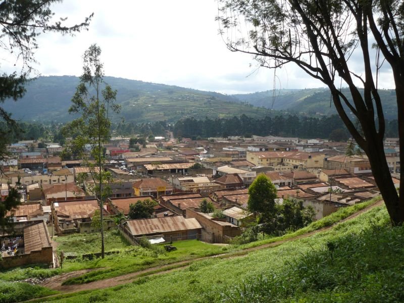
So, we start from the country of Ecuador (the state got its name from the equatorial line) - this is the east of South America. The path will lie to the west. Not far from the capital Quito, a special monument with a zero elevation rises. From here it goes conditional line, depicting the equator. Next to iconic place There is the Inti-Nyan Museum. You will have to overcome a small mountainous section of the Andes and pass through the beautiful forested ecological reserve of Cayambe-Coca, and then national park Kaibena. There is plenty to see and places to stay. It is advisable to cover this path on foot, or you can ride a bicycle.
Colombia
Next you will cross the Colombian border, which runs along the Putumayo River. A huge tract of jungle will stand in your way, all the way to the Caqueta River. To walk through tropical bushes, it is better to take a guide with you. Be extremely attentive to plants and animals; not everything that comes your way can be touched with your hands. Even a small, bright blue frog can be deadly poisonous. After crossing Caqueta, you will see in front of you great plain. These areas are not particularly populated. You should head for the village of Pacoa, it is located exactly on the equator. Here you will rest and prepare for your further journey.

Brazil
Next you will find yourself in the largest South American country - Brazil. large state Amazonas, to the small town of Sao Gabriel da Cachoeira. About 40 thousand people live here, mostly descendants of local aborigines - the Tupi-Guarani Indians. All the way to the Atlantic coast you will have to navigate through Brazilian forests. Along the way you will meet many rivers and lakes. In the end you have to come to seaport Masara, which is located at the mouth of the world's longest river - the Amazon. By the way, part of the path can be covered along it. At this point you will have to board a liner or ship to cross the equator Atlantic Ocean.

Sao Tome and Principe
Closer to the Gulf of Guinea you will meet on your way Island state Democratic Republic Sao Tome and Principe. These are 8 islands of volcanic origin, where 163 thousand people live - descendants of the first Portuguese colonists. Locals they make beautiful crafts from wood, and they also love and can dance to the rhythm of “dex” - this is passionate samba, sokope and dansu-conga.

Gabon
After 300 kilometers along the Gulf of Guinea you will be greeted by African continent, the country of Gabon and the capital port city of Libreville. This unitary French-speaking state is considered one of the most stable and rich on the Black Continent. 80% of Gabon's territory is occupied by evergreen forests, with many large rivers, even navigable. Elephants, monkeys, hippopotamuses and a very dangerous poisonous snake live here - the Gaboon viper. Therefore, be careful when crossing this state. You will have to go through the Ayvindo National Park, where you will get acquainted with all the Gabonese diversity of flora and fauna.

Congo
Then you enter the Republic of the Congo - the former French colony. The country's main income comes from the sale of oil. Here you can buy some kind of charismatic mask carved from wood as a keepsake. By the way, Ebola fever was raging here quite recently, so big cities You don't have to stop by. Skip by settlements Etumbi (Ebola epicenter), Makuya and Onya too. The population here cannot be called civilized; many still live by hunting and small-scale farming. Therefore, do not count on special comfort.

Democratic Republic of the Congo
Crossing the Ubangi River, you find yourself in another state of the Congo - this is a former Belgian colony. This is also the name of the deepest African river, which will also need to be crossed. The cosmopolitan town of Mbandaka will appear on your way; geographically, it is located right on the equator. The city is not very hospitable, there are still ongoing internecine wars between clans. Therefore, it would be better for you to get out of there quickly. Unfortunately, this state is recognized as the rape capital of the world. But the nature is beautiful.

Uganda
In the area of Lake Edward lies another state border, after which you will get to Uganda - ancient land pygmies. You will have to swim across the region of the Great African Lakes, cross savannahs and massifs tropical forests. The path lies through the capital of the country - Kampala, which is located on the coast of the huge Lake Victoria.
Kenya
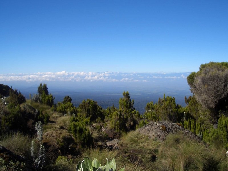
After crossing the lake, you will immediately find yourself in Kenya, which is considered the ancestral home of humanity. Unlike other African countries, Kenya is considered a developing agricultural country. Coffee, tea and fruits are grown here for export. Tourism is developed in Kenya; people go here on famous safaris. There are more than 60 national parks in the country. After visiting the town of Dadaeb, get ready for new customs.
Somalia
It is recommended to drive through Somalia with its desert and savannah plains quickly. It's turbulent here, the Mujahideen are constantly sorting things out among themselves. Along the way you can meet giraffes, elephants and lions. Take a break before long-distance voyage on the Indian Ocean, stop in the city of Jamama. There are cheap bananas and good clothes made of cotton.

Indonesia
Swim across Indian Ocean, you will have to cross 17 Indonesian islands located at the zero parallel. They are all very picturesque and beautiful. Here you can enjoy perfect holiday after extreme Africa. Beaches, comfortable hotels and excellent cuisine. Take a good rest here, because the longest voyage lies ahead - through Pacific Ocean, back to Ecuador, to the starting point.
IN close proximity from parallel 0°. What is this river that crosses the equator twice? On what continent is the watercourse located? This article provides detailed answers to fascinating geographical mysteries.
On which continent is there a river that crosses the equator twice?
Usually geographic latitude counted from parallel 0°. This is the equator, crossed by all meridians. An imaginary line on a globe and map is conditional border between the Northern and Southern Hemispheres. The equator crosses:
- Africa - in the central part of this continent;
- South America - in the north;
- many large and small islands in the Pacific, Indian and Atlantic oceans.
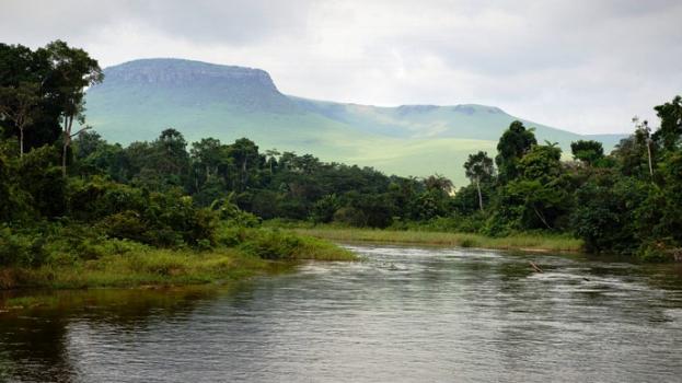
Thousands of streams on these landmasses flow near latitude 0°. But there's only one largest river, which crosses the equator twice - r. Congo on mainland Africa. The second largest and hottest is very arid in its northern part. The center of the continent is located in the equatorial climate zone, where precipitation falls more than 2000 mm/year, but evaporation is also significant.
A huge area in this region is occupied by hylea - moist evergreen forests (jungles). West Side Central Africa is washed by the relatively cold waters of the Gulf of Guinea. To the north, the forest belt gradually turns into the endless expanses of savannah. From the east and west, the Congo River basin is limited by mountain ranges that serve as a watershed.
Congo - the most abundant river in Africa
The largest natural watercourses in the Atlantic Ocean basin have similarities and differences. On the continent of Africa, the rainfall type predominates in the feeding of such rivers. After all, the sources are located in the equatorial regions, where there is a lot of precipitation. The Nile, the longest waterway, begins in mountain ranges East Africa, flows north and flows into the Mediterranean Sea. crosses the equator or parallel 0° twice. It is easy to see this if you look at a map of the world or Africa. First, a watercourse from an area in the Southern Hemisphere heads north, receiving numerous tributaries along the way. The river turns southwest approximately 2° north of the equator. Congo returns to the Southern Hemisphere and heads towards the Gulf of Guinea. This is the deepest river that crosses the equator twice. The Congo in terms of runoff volume in the world ranking is second only to the South American river. Amazon. On maps of Africa, another hydronym is often indicated - Zaire. Historically, the river has two names.
The Congo Basin is located in the subequatorial and equatorial climatic zones. The river receives numerous tributaries in the Northern and Southern Hemispheres. The area south of the equator accounts for about 75% of the basin, which affects the water regime. Thus, the level rise is observed from March to October, when the northern tributaries receive the most precipitation. The second peak occurs between October and March, when the wettest conditions are found south of the equator. The flow of the Congo River is uniform throughout the year. To this it is also necessary to add the presence of a significant drop in the riverbed, rapids and waterfalls in the upper reaches.

Congo depth
Famous American publication National Geographic leads comparative analysis high water content of the Earth's rivers. The first place is occupied by the Amazon, crossing the continent of South America from west to east. The African river, which crosses the equator twice, surpasses in depth other waterways of the planet studied by experts. According to National Geographic, the depth of the Congo in some parts of the riverbed is more than 230 m. This is almost twice as deep as the Amazon.
Geographers explain the significant depth of the Congo by the structure of the riverbed and the entire river valley. The largest watercourse in Central Africa, on its way to the Gulf of Guinea, has been making its way through a gorge in mountainous terrain for thousands of years. Now this is the South Guinea Plateau, where the Congo channel narrows to 300-500 m. But on the plain, the African river spreads over 10-15 km. A powerful stream of water rushes into the gorge and fills it. The river flow in this section reaches a record level of 42 thousand m 3 /sec.
Congo Basin Exploration
The Portuguese trader and navigator Diogo Can explored the western coast of Africa and the confluence of the Congo and in 1482 he discovered the sources in the mountains. The river crosses the equator twice in Central Africa. Long time this area was the least studied on the mainland and was replete with “white spots.”
Difficult jungle, swampy terrain, and lack of roads made the work of cartographers and other scientists difficult. One of them compared the gilley to a “green hell”, because in the forest travelers had to fight their way through the forest with the help of a machete. The vines are rampant around and do not allow passage, powerful and numerous stilted roots grow. It’s gloomy and damp under the forest canopy, because almost every day it's raining, and the crowns of several tiers of trees and shrubs block the light. Animals prefer to live and feed on branches, occasionally going down.

Main characteristics of the Congo River
Once we know which one crosses the equator twice, we can describe it in more detail. The length of the channel, according to various estimates, is 4.3-4.7 thousand km. A more accurate answer depends on which of the river's tributaries is taken as its source. In general, the basin area reaches an impressive size - almost 3.7 million km 2. Most geographical publications name the river originating on the Shaba Plateau as its source. west of the city Kisangani.
On its way to the Atlantic Ocean, the Congo receives numerous left and right tributaries. The largest of them are: Mobangi, Ruki, Lulongo and others. Significant differences between the heights of the sources and the mouth, the fall and slope of the river in individual sections provide its enormous hydroelectric potential. Several powerful hydroelectric power stations have been built to supply energy to Central African countries. The lower one is actively used for shipping and wood rafting. Fishing is developed; Nile perch and freshwater herring are caught in the waters of the Congo.
The need to accurately determine the location on earth's surface itself and surrounding objects became especially relevant for humans with the beginning of active exploration of the planet.
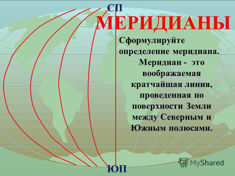
Geographical coordinates- latitude and longitude - are determined by the point of intersection of two imaginary lines - a parallel and a meridian. The most long parallel, from which latitude begins - the equator.
origin of name
An imaginary line that is formed on a surface globe points located at equal distances from both poles divide the planet into two hemispheres, two hemispheres. The word for such a border has ancient roots. The Latin "aequator", equalizer, is derived from the verb "aequō" - to equalize. The “equator” entered international practice from German language, from Äquator.
This word has more general meaning. In geometry, a three-dimensional body that simultaneously has mutual perpendicular to the axis and a plane of symmetry, has its own equator, its own longest parallel - the intersection of the surface given body with a plane of symmetry. In astronomy, the celestial equator and the magnetic equator of a planet or star are known.
The earth is a geoid
The belief that the Earth is shaped like a flat disk was only questioned by ancient Greek scientists. TO end of the 19th century century, it became clear that the shape of our planet is not just an ideal sphere, but a special body of rotation - the geoid, the surface of which is influenced by many factors - from the force of gravity to the “cosmic wind”. Two points of the geoid are determined by the axis of its rotation - these are North and South Pole. On equal distance from them is the longest parallel on Earth, the earth’s “waist” - the equator. 
But the geoid does not accurately, but only approximately describes the shape of the planet. This is how it would be in the absence of mountains and depressions, if there were only a calm, undisturbed surface of the world ocean. This level plays important role in navigation and geodesy - from it a report of vertical marks is kept for various technical and engineering objects.
Equator length
You can also understand which parallel is the longest by looking at the specific values of the geometric dimensions of the geoid. The radius of the equator, as a circle “drawn” along the surface of the Earth, equal to the radius planets. Accurate measurements show that this parameter differs in different points planets - the polar radius is 21.3 km less than the equatorial one. average value- 6371 km
Using the formula for circumference - 2πR - you can calculate the length of the equator. Different geophysical standards define figures with a difference of about 3 m, on average - 40075 km. along the meridian - 40,007 km, which proves the special geometric qualities of the geoid.
Zero latitude
The coordinate grid that covers the globe - a visual model of the globe - is formed by 360 meridians connecting the two poles, and 180 lines parallel to the equator, distributed in 90 pieces to the poles, on both sides of it. The beginning of the longitude count since 1884 is considered to be the meridian drawn through the southeastern English capital. The longest parallel dividing the Northern and Southern Hemisphere- the beginning of the latitude count. 
The coordinates are angular values, are measured in degrees. Longitude is the angle between the plane passing through the prime - Greenwich - meridian and the one designated by the line connecting the earth's poles and drawn through this point. East of Greenwich to 180° longitude is called eastern and is considered positive, to the west it has negative values and is called Western.
Points equidistant from the poles form the equatorial plane. A radius drawn from the center of the globe through a given point on its surface forms an angle with this plane, the magnitude of which is the latitude. The longest parallel has zero latitude. To the north of the equator this angle is considered positive - from 0° to 90°, to the south - negative.
Signs and rituals
The equator is just an illusory border between two hemispheres, but it has always excited people's imagination. Among the sailors different countries It is customary to observe special rituals when crossing zero latitude, especially for those who do it for the first time. Where the equator passes through inhabited areas, special signs and structures are invariably erected to make the conventional line real. Rarely will a tourist miss the opportunity to stand with one foot in Yuzhny and the other in Yuzhny. After this, it is impossible to forget what the longest parallel on the globe is called. 
But the equatorial zones of the Earth have other unique characteristics, giving them special value. Gravitational attraction here is slightly less than in other latitudes, and the momentum of the rotation of the globe is greater. This allows you to save significantly on withdrawals spaceships into orbit. It is no coincidence that the most effective starting point is located in the equatorial region of the South American coast. space complex- Kourou cosmodrome.

Air purifier from dustTo breathe clean air, do not inhale dust, you need a good air purifier. But what does “good” mean? What characteristics should it have...
0 0
Wellness 
10 interesting facts about intimacy, which you probably didn’t know aboutCheck out the most interesting and impressive facts about sexual activity that will surprise you....


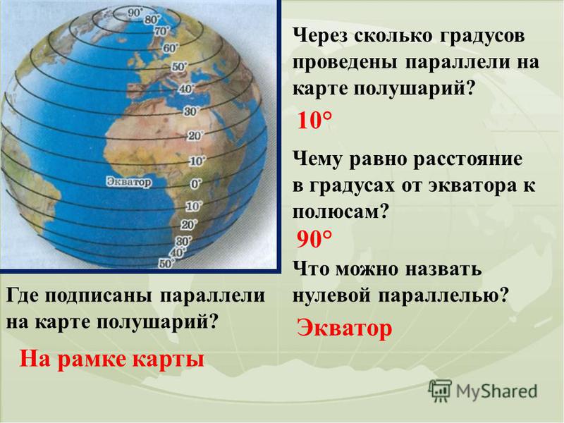
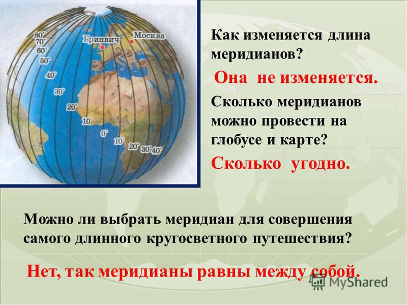
What direction do the parallels show? West East. Where do the parallels begin? From the equator. The journey along which parallel will be shorter - the 60th or the 40th? 60th. Point A is located on the 45th parallel, and point B is on the 25th. Which one is located closer to the equator? 25th.


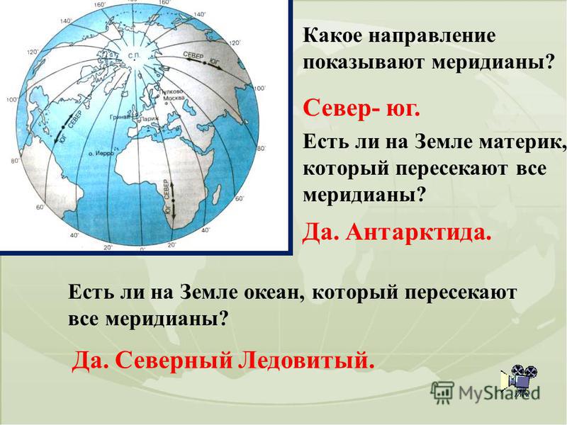

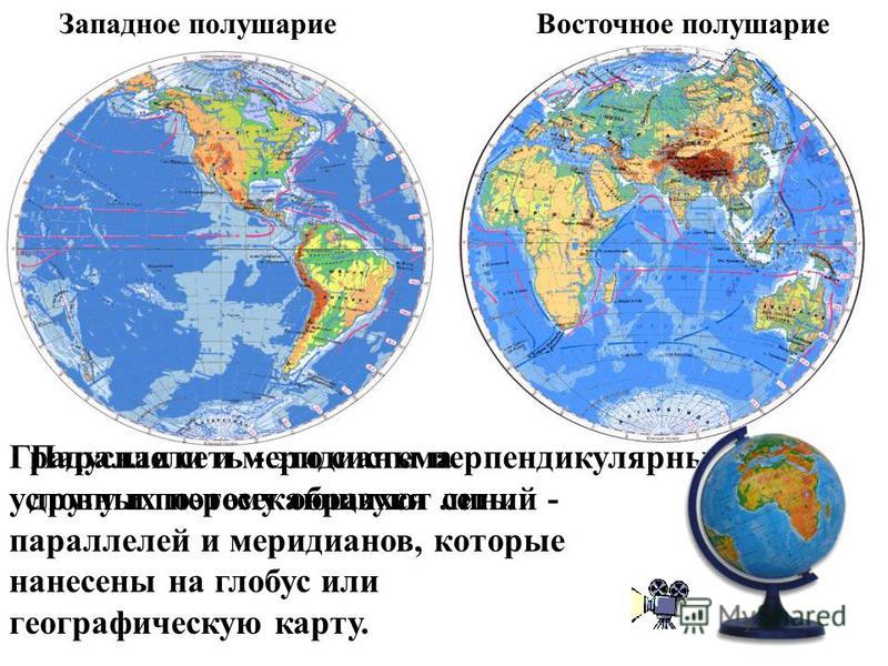 17 Po physical map hemispheres in the atlas, determine which continents and oceans cross the equator from west to east. Pacific Ocean, South America, Atlantic Ocean, Africa, Indian Ocean. Which continent is located in the southern and eastern hemispheres. Australia. What hemispheres is the Northern Hemisphere in? Arctic Ocean. In the north, west and east. In which hemispheres is the continent of South America located? In the north, south and west.

In which hemispheres is the continent of Africa located? In the north, south, east and west. What oceans are found in all four hemispheres? Pacific and Atlantic. In which direction does the Amazon River flow? South America, if it flows into the Atlantic Ocean. In the east. In which direction does the Nile River flow in Africa if it flows into the Mediterranean Sea. In the north. In which direction does the Mississippi River flow? North America if it falls into Gulf of Mexico. In the south.
