Federation - a line and a vertical surface passing along this line that define the limits of the state territory (land, water, subsoil and airspace) of Russia, the spatial limit of the state sovereignty of the Russian Federation.
The protection of the state border is carried out by the Border Service of the FSB of Russia within the border territory, as well as by the Armed Forces of the Russian Federation (air defense and naval forces) - in the airspace and underwater environment. The arrangement of border checkpoints is in charge of the Ministry of Transport of the Russian Federation.
Russia recognizes the existence of borders with 18 states: Norway, Finland, Estonia, Latvia, Lithuania, Poland, Belarus, Ukraine, Georgia, Azerbaijan, Kazakhstan, China, Mongolia, North Korea, Japan and the United States, as well as the partially recognized Republic of Abkhazia and South Ossetia. The length of the Russian border (excluding the annexation of Crimea in 2014) is 60,932 km according to the Border Service of the FSB of the Russian Federation (or 62,269 km according to other data), including 38 thousand km of maritime borders; Among the land borders, 7 thousand km of borders along rivers and 475 km along lakes stand out.
Length
Russia has maritime boundaries of exclusive economic zones (EEZ) in the Barents Sea, Chukchi, Bering, Okhotsk, Japan, Azov, Black and Baltic seas with the following countries: Norway, USA, Japan, North Korea, Abkhazia, Turkey, Ukraine, Poland, Sweden, Lithuania, Estonia, Finland. According to the Federal Law of December 17, 1998 No. 191-FZ “On the Exclusive Economic Zone of the Russian Federation” and the corresponding UN Convention on the Law of the Sea of 1982, the internal border of the exclusive economic zone of the Russian Federation is the external border of the territorial sea (territorial waters), and the external border of the EEZ is at a distance of 200 nautical miles (370.4 km) from the baselines from which the breadth of the territorial sea is measured.
The Russian Federation is a huge country, ranking first in the world in terms of area. The states bordering Russia are located from all directions of the world, and the border itself reaches almost 61 thousand km.
Types of borders
The border of a state is the line that limits its actual area. Territory includes areas of land, water, underground minerals and airspace located within a country.
There are 3 types of borders in the Russian Federation: sea, land and lake (river). The sea border is the longest of all, it reaches about 39 thousand km. The land border is 14.5 thousand km long, and the lake (river) border is 7.7 thousand km long.
General information about all states bordering the Russian Federation
Which states does the Federation recognize its neighborhood with? 18 countries.
Name of states bordering Russia: South Ossetia, Republic of Belarus, Republic of Abkhazia, Ukraine, Poland, Finland, Estonia, Norway, Latvia, Lithuania, Kazakhstan, Georgia, Azerbaijan, United States of America, Japan, Mongolia, China First order countries are listed here .
Capitals of states bordering Russia: Tskhinvali, Minsk, Sukhum, Kiev, Warsaw, Oslo, Helsinki, Tallinn, Vilnius, Riga, Astana, Tbilisi, Baku, Washington, Tokyo, Ulaanbaatar, Beijing, Pyongyang.
South Ossetia and the Republic of Abkhazia are partially recognized because not all countries in the world have recognized these countries as independent. Russia did this in relation to these states, therefore, it approved the neighborhood and borders with them.
Some states bordering Russia argue about the correctness of these borders. For the most part, disagreements arose after the end of the USSR.

Land borders of the Russian Federation
The states bordering Russia by land are located on the Eurasian continent. These also include lake (river) ones. Not all of them are currently protected; some of them can be crossed freely with only a passport of a citizen of the Russian Federation, which is not always necessarily checked.
States bordering Russia on the mainland: Norway, Finland, Belarus, South Ossetia, Ukraine, Republic of Abkhazia, Poland, Lithuania, Estonia, Kazakhstan, Latvia, Georgia, Azeybardzhan, Mongolia, People's Republic of China, North Korea.
Some of them also have a water border.
There are Russian territories that are surrounded on all sides by foreign states. Such areas include the Kaliningrad region, Medvezhye-Sankovo and Dubki.
You can travel to the Republic of Belarus without a passport and any border control along any of the possible roads.

Maritime borders of the Russian Federation
Which states does Russia border by sea? The sea border is considered to be a line 22 km or 12 nautical miles from the coast. The country's territory includes not only 22 km of water, but also all the islands in this sea area.
States bordering Russia by sea: Japan, the United States of America, Norway, Estonia, Finland, Poland, Lithuania, Abkhazia, Azerbaijan, Kazakhstan, Ukraine, North Korea. There are only 12 of them. The length of the borders is more than 38 thousand km. Russia has only a maritime border with the USA and Japan; there is no land boundary line with these countries. There are borders with other states both by water and by land.

Settled disputed sections of the border
At all times, there have been disputes between countries over territories. Some of the disputing countries have already agreed and are no longer raising this issue. These include: Latvia, Estonia, People's Republic of China and Azerbaijan.
The dispute between the Russian Federation and Azerbaijan occurred over a hydroelectric complex and water intake structures that belonged to Azerbaijan, but were in fact located in Russia. In 2010, the dispute was resolved, and the border was moved to the middle of this waterworks. Now the countries use the water resources of this hydroelectric complex in equal shares.
After the collapse of the USSR, Estonia considered it unfair that the right bank of the Narva River, Ivangorod and the Pechora region remained the property of Russia (Pskov region). In 2014, the countries signed an agreement on the absence of territorial claims. The border did not suffer any noticeable changes.

Latvia, like Estonia, began to lay claim to one of the districts of the Pskov region - Pytalovsky. An agreement with this state was signed in 2007. The territory remained the property of the Russian Federation, the border did not change.
The dispute between China and Russia ended with the demarcation of the border along the center of the Amur River, which led to the annexation of part of the disputed territories to the People's Republic of China. The Russian Federation transferred 337 square kilometers to its southern neighbor, including two plots in the Tarabarov region and one plot near Bolshoy Island. The signing of the agreement took place in 2005.
Unsettled disputed sections of the border
Some disputes over territory are not closed to this day. It is not yet known when the agreements will be signed. Russia has such disputes with Japan and Ukraine.
The Crimean Peninsula is a disputed territory between Ukraine and the Russian Federation. Ukraine considers the 2014 referendum illegal and Crimea occupied. The Russian Federation established its border unilaterally, while Ukraine passed a law creating a free economic zone on the peninsula.
The dispute between Russia and Japan is over the four Kuril Islands. The countries cannot come to a compromise because both believe that these islands should belong to them. These islands include Iturup, Kunashir, Shikotan and Habomai.
Boundaries of exclusive economic zones of the Russian Federation
An exclusive economic zone is a strip of water adjacent to the border of the territorial sea. It cannot be wider than 370 km. In this zone, the country has the right to develop subsoil resources, as well as to explore and preserve them, to create artificial structures and their use, and to study water and the bottom.
Other countries have the right to move freely through this territory, install pipelines and otherwise use this water, but they must take into account the laws of the riparian state. Russia has such zones in the Black, Chukchi, Azov, Okhotsk, Japanese, Baltic, Bering and Barents seas.
RUSSIAN BORDER
Russian border - a line and a vertical surface passing along this line, defining the limits of the state territory (land, water, subsoil and airspace) of Russia, the spatial limit of the state sovereignty of the Russian Federation.
The protection of the state border is carried out by the Border Service of the FSB of Russia within the border territory, as well as by the Armed Forces of the Russian Federation (air defense and naval forces) - in the airspace and underwater environment. The arrangement of border points is in charge of the Federal Agency for the Development of the State Border of the Russian Federation.
Russia recognizes the existence of borders with 16 states: Norway, Finland, Estonia, Latvia, Lithuania, Poland, Belarus, Ukraine, Georgia, Azerbaijan, Kazakhstan, China, Mongolia, North Korea, Japan and the USA, as well as the partially recognized Republic of Abkhazia and South Ossetia. The length of the Russian border is 62,269 km
The main territory of the Russian Federation borders by land with 14 UN member states and two partially recognized states (the Republic of Abkhazia and South Ossetia). Only the semi-exclave Kaliningrad region borders Poland and Lithuania. The small enclave of Sankovo-Medvezhye, part of the Bryansk region, is surrounded on all sides by the border with Belarus. There is an enclave of Dubki on the border with Estonia.
A Russian citizen can freely, with only an internal passport, cross the border with the Republic of Abkhazia, Belarus, Kazakhstan, Ukraine and South Ossetia.
All sections of the border, except the border with Belarus, are allowed to be crossed only at established checkpoints in compliance with all procedures provided for by law. The only exception is the border with Belarus. You can cross it anywhere; there are no border controls. Since 2011, any forms of control have been abolished at the Russian-Belarusian border.
Not all land borders are secure.
By sea, Russia borders on twelve countries . Russia has only a maritime border with the USA and Japan. With Japan, these are narrow straits: La Perouse, Kunashirsky, Izmena and Sovetsky, separating Sakhalin and the Kuril Islands from the Japanese island of Hokkaido. And with the United States, this is the Bering Strait, the border along which separates Ratmanov Island from Kruzenshtern Island. The length of the border with Japan is approximately 194.3 kilometers, with the United States - 49 kilometers. Also along the sea lies a section of the border with Norway (Barents Sea), Finland and Estonia (Gulf of Finland), Lithuania and Poland (Baltic Sea), Ukraine (Azov and Black Seas), Abkhazia - Black Sea, Azerbaijan and Kazakhstan (Caspian Sea), and North Korea (Sea of Japan).
The total length of the borders of the Russian Federation is 60,932 km.
Of these, 22,125 km are land borders (including 7,616 km along rivers and lakes).
The length of Russia's maritime borders is 38,807 km. Of them:
in the Baltic Sea - 126.1 km;
in the Black Sea - 389.5 km;
in the Caspian Sea - 580 km;
in the Pacific Ocean and its seas - 16,997.9 km;
in the Arctic Ocean and its seas - 19,724.1 km.
MAP OF THE RUSSIAN FEDERATION
Russia has common borders with a number of European countries. Russia (Murmansk region) and Norway have 196 km of borders. The length of the border between Russia (Murmansk region, Karelia, Leningrad region) and Finland is 1340 km. A border line of 294 km separates Estonia and the Leningrad and Pskov regions of Russia. The Russian-Latvian border is 217 km long and separates the Pskov region from the territory of the European Union. The Kaliningrad region, located somewhat, has 280 km of border with Lithuania and 232 km with Poland.
The total length of Russia's borders, according to the border service, is 60,900 km.
Western and southwestern borders.
Russia has 959 km of common border with Belarus. Russia and Ukraine share 1,974 km of land and 321 km of sea border. With Belarus are the Pskov, Smolensk and Bryansk regions, and with Ukraine - the Bryansk, Belgorod, Voronezh and Rostov regions. In the Caucasus Mountains region, Russia has 255 km of border with Abkhazia, 365 km with Georgia, 70 km with South Ossetia (or 690 km of border with Georgia according to the UN), as well as 390 km of border strip with Azerbaijan. Abkhazia is bordered by the Krasnodar Territory and Karachay-Cherkessia, and Georgia is bordered by Karachay-Cherkessia, Kabardino-Balkaria, North Ossetia, Ingushetia, Chechnya and Dagestan. With South Ossetia North Ossetia. Dagestan borders Azerbaijan.
Estonia, Latvia, the Republic of China (Taiwan) and Japan are trying to dispute some of Russia’s border territories.
Southern borders.
The longest border of the Russian Federation is with Kazakhstan – 7512 km. The Russian regions bordering Central Asia are the Astrakhan, Volgograd, Saratov, Samara, Orenburg, Chelyabinsk, Kurgan, Tyumen, Omsk, Novosibirsk regions, as well as the Altai Territory and the Altai Republic. Russia has a 3,485 km border with Mongolia. Mongolia is bordered by Altai, Tuva, Buryatia and the Trans-Baikal Territory. Russia has a 4,209 km border with the People's Republic of China. This border separates the Altai Republic, Amur Region, Jewish Autonomous Okrug, Khabarovsk and Primorsky Territories from China. Primorsky Krai also has a 39 km border with North Korea.
Russia shares exclusive economic zone borders with Norway, the USA, Japan, Abkhazia, Ukraine, Sweden, Estonia, Finland, North Korea, Turkey, Poland and Lithuania.
Maritime borders.
Russia borders by sea with 12 countries - the USA, Japan, Norway, Finland, Estonia, Lithuania, Poland, Ukraine, Abkhazia, Azerbaijan, Kazakhstan and North Korea.
Switzerland is a country in Western Europe. It borders on several other European countries and is landlocked; part of the border runs through the Alpine Mountains. The ancient name of Switzerland is Helvetia, or Helvetia.
Borders of Switzerland
The area of Switzerland is about 3 thousand square meters. km. There are several other states nearby. Switzerland borders Germany to the north, France to the west, Austria and Liechtenstein to the east, and Italy to the south.
A significant part of the border with Germany runs along the Rhine River, and near Schaffhausen the river crosses into Swiss territory. Then, on the eastern side, part of the border with Germany and Austria runs along the shores of Lake Borden. with France it also passes along the water shore - this is Lake Geneva, it is known for its beauty and picturesque landscapes. Of all Switzerland's borders with different countries, the longest is Italian. Its length is approximately 741 km. To feel the difference, it is useful to say that the border with France is only 570 km long, and with Germany it is about 360 km. The total length of the border with Austria and Liechtenstein is about 200 km.
Geography of Switzerland
More than half of Switzerland's territory is covered by the Alps (only 58% of the territory). Another 10% of Switzerland is occupied by the Jura Mountains. It is not surprising that the ski resorts of Switzerland are among the most popular in the world: there are many beautiful peaks and slopes. The highest mountain in the Jura system, Mont Tandre, is located in Switzerland. The highest point in Switzerland, however, is in the Alps, the Dufour peak. Lake Lago Maggiore is the most significant lake in the country.
In the central part of Switzerland there is a mountain plateau, it is called the Swiss Plateau. Most of the industry is located in this part of the country. Agriculture and cattle breeding are also especially developed here. Almost the entire population of the country lives in the Swiss Plateau.
The territory of Switzerland is largely covered by various lakes, many of which are of glacial origin. In total, as experts have calculated, the country contains about 6% of the world's fresh water reserves! Despite the fact that the country's territory is relatively small. Large rivers such as the Rhine, Rhone and Inn begin in Switzerland.
Switzerland is usually divided into 4 regions. The flattest is the northern one, where the cantons of Aargau, Glarus, Basel, Thurgau, St. Gallen and Zurich are located. The western region is already more mountainous, with Geneva, Bern, Vaud, Friborg and Neuchâtel located there. In central Switzerland there are the cantons of Unterwalden, Lucerne, Uri and Schwyz. The southern region of the country is very small in area.
Why is Switzerland called that?
The Russian name of the country goes back to the word Schwyz - this was the name of the canton (as the administrative unit is called in Switzerland), which became the nucleus for all the other cantons to unite around it in 1291. In German this canton is called Schweiz.
Video on the topic
Once upon a time, a union country called Czechoslovakia had a state border, after crossing which one could get into two completely different worlds - capitalist and socialist. The first was represented on the map by West Germany (FRG) and Austria, the second by East Germany (GDR), Poland, Hungary and the Soviet Union (Ukrainian SSR). But after the well-known political events of the early 90s, the current Czech Republic has only four neighbors left - the now united Germany, Austria, Poland and Slovakia, which separated from it.

USSR, goodbye!
The current independent Czech Republic, or the Czech Republic, began to change and legally formalize immediately after leaving the CSFR (Czech and Slovak Federal Republic) on January 1, 1993. Thus, for two “transitional” years before the collapse, the Czechoslovak Socialist Republic (Czechoslovak Socialist Republic) created after World War II was called. A country in which the military-political bloc of socialist countries called the “Warsaw Pact” was disbanded a little earlier.For four decades, Czechoslovakia has been building socialism, both with the capitalist Federal Republic of Germany and Austria, and with other representatives of the European socialist camp - Hungary, the German Democratic Republic, Poland and even the USSR. But, since political and closely related territorial redistributions in Europe took place not only on the territory of the former Czechoslovakia, but also in other countries of the continent, the changes turned out to be serious. Firstly, the “pro-Soviet” GDR and the “hostile” FRG, and therefore willingly accepting Czech emigrants, which became a united Germany, disappeared from the world map forever.
Secondly, after a peaceful “divorce” with Slovakia, later called “velvet”, the sovereign Czech Republic lost its common border not only with Hungary, but also with Ukraine, which had by that time left the USSR. By the way, the disintegration of Czechoslovakia into two separate states is the only such case in Europe that was not accompanied by armed conflict, bloodshed, mutual territorial border claims and other revolutionary excesses.
Finally, thirdly, the newly created country in the center of the continent has a new border - with its sister Slovakia. And the total length of the border strip was now 1880 km. In Czechoslovakia it was, naturally, longer. The longest section of the Czech border is located in the north and connects it with Poland; it is 658 km. In second place and slightly inferior to the leader is the Czech-German border in the west and north-west of the country - 646 km. The third longest is the southern state border with Austria, it reaches 362 km. And the last, fourth place is occupied by the eastern and youngest border, with Slovakia - only 214 km.
Edges at the border
Individual regions of the Czech Republic are called “regions” and almost all of them border on one or even two neighboring countries. In particular, the South Bohemian Region, with its capital in the city of Ceske Budejovice, located in the south of the historical region of Bohemia and, partly, in Moravia, has 323 km of common borders with Austria and Germany. Germany is bordered by four other regions - Pilsen (its capital is Pilsen, the city of Prazdroj beer and Skoda cars), Karlovy Vary (a half Russian-speaking resort town with healing springs of Karlovy Vary), Ustetsky (Usti nad Labem, famous for the Ore , Labskie and Lusatian mountains) and Liberec (Liberec). Moreover, the latter is territorially close not only to Germany (the length of the common border is 20 km), but also to Poland (130 km).With the former Polish People's Republic, with its mining Silesian region, the Czech Republic is connected by a common border in four other regions - in Pardubice (Pardubice), Kralovegrad (Hradec Kralove), Olomouc (Olomouc), where it has the longest length - 104 km, and , finally, in Moravian-Silesian (Ostrava). In the north and northeast, the Moravian-Silesian Region is in close contact with Poland, and in the southeast - with Slovakia. The Carpathian region of Zlín (Zlín) and the South Moravian region (Brno) also have a common border with a “relative”, next to which there is not only the Slovak, but also the Austrian border territory.
United Europe
In 2004, the Czech Republic entered the zone of the so-called European Union and the Schengen Agreement, removing security and opening borders for free movement. Moreover, all border states - Austria, Germany, Poland and Slovakia - also joined the European Union. All the more surprising is the fact that the first places in the number of foreigners who came to the Czech Republic not only for the sake of such popular tourism (Slovaks are out of competition), but also settled here, are occupied by Ukrainians, Vietnamese and Russians.
In the northeastern part of Eurasia there is a country occupying 31.5 percent of its territory - Russia. It has a huge number of sovereign neighbors. Today, Russia's borders are impressively long. 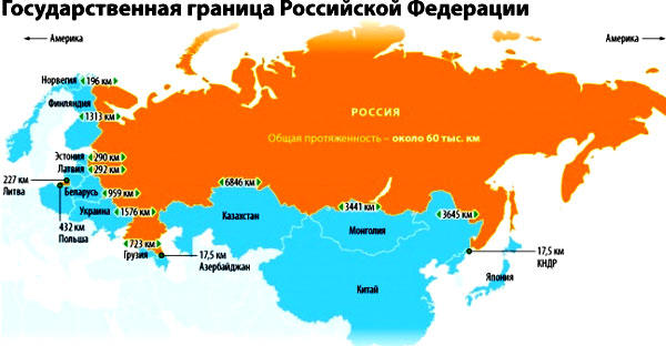
The Russian Federation is unique in that, being located simultaneously in Asia and Europe, it occupies the northern part of the first and the eastern expanses of the second.
Map of the southern border of the Russian Federation indicating all neighboring states
It is well known that the length of Russia’s borders is 60.9 thousand km. The land borders are 7.6 thousand km. Russia's maritime borders have a length of 38.8 thousand km.
What you need to know about the Russian state border
In accordance with the provisions of international law, the state border of Russia is defined as the surface of the globe. It includes both territorial waters and internal waters. In addition, the “composition” of the state border includes the bowels of the earth and airspace.
The state border of Russia is the existing water and territorial line. The main “function” of the state border should be considered the determination of current territorial limits.
Types of state borders
After the collapse of the great and mighty Soviet Union, the Russian Federation has the following types of borders:
- old (these borders were “inherited” by Russia from the Soviet Union);
- new.
A similar map of the borders of the USSR indicating the borders of the republics of the union
Old borders include those that coincide with the borders of states that were once full members of one big Soviet family. Most of the old borders are fixed by contracts concluded in accordance with current international standards. Such states include both relatively close Russia and, and.
Experts include those that border the Baltic countries, as well as the states of the CIS, as new borders. The latter, first of all, should include.
It is not for nothing that Soviet times drive patriotic-minded citizens of the older generation into nostalgia. The fact is that after the collapse of the Soviet Union, Russia lost more than 40 percent of its equipped border.
"Extirpated" boundaries
It is not for nothing that Russia is called a unique state. It has borders that are defined today as “extended” zones to the borders of the former Soviet Union.  Russia today has many problems with borders. They became especially acute after the collapse of the Soviet Union. On a geographical map everything looks quite beautiful. But in reality, the new borders of Russia have nothing in common with cultural and ethnic borders. Another significant problem is the categorical rejection by public opinion of the restrictions that arose in connection with the introduction of border posts.
There is another serious problem. After the collapse of the Soviet Union, the Russian Federation was unable to equip its new borders in a timely manner technically. Today, the solution to the problem is moving forward, but not fast enough.
Given the serious danger looming from some former Soviet republics, this issue remains at the forefront. The southern and western borders are predominantly land. East and north refer to water boundaries.
Map of the collapse of the Soviet Union
What you need to know about the key borders of the Russian Federation
By 2019, our country has a large number of neighbors. On land, our country borders on fourteen powers. It is important to note all neighbors:
- Republic of Kazakhstan.
- Mongolian state.
- Belarus.
- Polish Republic.
- Republic of Estonia.
- Norway.
Our country also has borders with the Abkhaz state and South Ossetia. But these countries are still not recognized by the “international community,” which still considers them part of the Georgian state.
Map of the Russian border with Georgia and the unrecognized republics
For this reason, the borders of the Russian Federation with these small states are not generally recognized in 2019.
Who does the Russian Federation border on land?
The most important land neighbors of the Russian Federation include the Norwegian state. The border with this Scandinavian state runs along the swampy tundra from Varanger Fjord. Important power plants of domestic and Norwegian production are located here.
Today, the issue of creating a transport route to this country, cooperation with which began in the deep Middle Ages, is being seriously discussed at the highest level.
A little further south lies the border with the Finnish state. The terrain here is wooded and rocky. This area is important for Russia for the reason that this is where active foreign trade takes place. Finnish cargo is transported to the port of Vyborg from Finland. The western border of the Russian Federation stretches from the Baltic waters to the Sea of Azov.
Map of Russia's western border showing all border states
The first section should include the border with the Baltic powers. The second section, no less important, is the border with Belarus. In 2019, it continues to remain free for the transport of goods and the travel of people. The European transport route, which is of great importance for Russia, passes through this section. Not long ago, a historic decision was made regarding the creation of a new powerful gas pipeline. The main point is considered to be the Yamal Peninsula. The highway will pass through Belarus to Western European countries.
Ukraine is not only geopolitically, but also geographically important for Russia. Given the difficult situation, which continues to be extremely tense in 2019, the Russian authorities are doing everything possible to lay new railway tracks. But the railway connecting Zlatoglavaya with Kiev still does not lose its relevance.
Who does the Russian Federation border on the sea?
Our most important water neighbors include Japan and the United States of America.
Map of the maritime borders of the Russian Federation
Both of these states are separated from the Russian Federation by small straits. The Russian-Japanese border is designated between Sakhalin, the South Kuril Islands and Hokkaido.
After the annexation of Crimea, Russia also had neighbors in the Black Sea. Such countries include Turkey, Georgia and Bulgaria. The oceanic neighbors of the Russian Federation include Canada, located on the other side of the Arctic Ocean.
The most important Russian ports include:
- Arkhangelsk.
- Murmansk.
- Sevastopol.
The great Northern Route begins from Arkhangelsk and Murmansk. Most of the waters there are covered with a huge crust of ice for eight to nine months. In 2016, by order of the President of the Russian Federation, preparations began for the creation of an underwater Arctic highway. It is assumed that this route will use nuclear submarines to transport important cargo. Of course, only submarines that have been decommissioned will take part in the transportation.
Disputed areas
In 2019, Russia still has some unresolved geographic disputes. Today the following countries are involved in the “geographical conflict”:
- Republic of Estonia.
- Latvian republic.
- People's Republic of China.
- Japan.
If we take into account that the so-called “international community” denies the annexation of Crimea to Russia, ignoring the results of the referendum held in March 2014, then Ukraine should be added to this list. In addition, Ukraine seriously lays claim to some Kuban lands.
The issue of Transnistria, also important for our country, is being resolved to a greater extent with the Moldavian Republic. Some experts believe that the “Crimean issue” is also relevant for Turkey. The dispute continues regarding South Ossetia and Abkhazia. But these countries are not part of the Russian Federation, so this issue is considered from a different perspective.
Disputed section of the Russian-Norway border
The so-called “Arctic issue” in the near future, it seems, will only be a method of “subtle trolling” for some of Russia’s maritime neighbors.
Claims of the Republic of Estonia
This issue is not discussed as diligently as the “Kuril Islands problem.” And the Republic of Estonia lays claim to the right bank of the Narva River, which is located on the territory of Ivangorod. Also, the “appetites” of this state extend to the Pskov region.
Five years ago, an agreement was concluded between the Russian and Estonian states. It outlined the delimitation of water spaces in the Gulf of Finland and Narva Gulf.
The “main hero” of Russian-Estonian negotiations is considered to be “Saatse’s Boot”. It is in this place that bricks are transported from the Urals to European countries. Once upon a time they wanted to transfer the “boot” to the Estonian state in exchange for other parts of the land. But due to significant amendments made by the Estonian side, our country did not ratify the agreement.
Claims of the Republic of Latvia
Until 2007, the Republic of Latvia wanted to obtain the territory of the Pytalovsky district, which is located in the Pskov region. But in March an agreement was signed according to which this area should remain the property of our country.
What China wanted and what it achieved
Five years ago, the demarcation of the Chinese-Russian border was carried out. According to this agreement, the People's Republic of China received a land plot in the Chita region and 2 plots near the island of Bolshoy Ussuriysky and Tarabarov.
In 2019, a dispute continues between our country and China regarding the Republic of Tuva. In turn, Russia does not recognize Taiwan's independence. There are no diplomatic relations with this state. Some seriously fear that the People's Republic of China is interested in dividing Siberia. This issue has not yet been discussed at the highest level, and dark rumors are very difficult to comment on and analyze.
China-Russia border map
2015 shows that there should not be any serious geographic friction between Russia and China in the near future.
Maritime disputed areas
The “maritime” dispute between Russia and Ukraine once concerned not only Azov, but also the Bosporus Strait. The site includes the Tuzla Spit, which was the subject of fierce diplomatic battles before the 2014 referendum. It is important to understand that the Tuzla braid is not of particular value. This is a small piece of land, favored by Kerch and Temryuk fishermen. Today the Tuzla issue is still discussed. But not with the Ukrainian side, but with the specialists leading the construction of the Kerch Bridge.
There was once a serious dispute between Russia, Kazakhstan, Azerbaijan and Turkmenistan regarding the division of the Caspian Sea. In 2003, an agreement concluded between all parties to the dispute was finally signed. According to this agreement, the Caspian Sea is partially divided along the median line.