There are many different coordinate systems, all of which are used to determine the position of points on the earth's surface. These include mainly geographic coordinates, plane rectangular and polar coordinates. In general, coordinates are usually called angular and linear quantities that define points on any surface or in space.
Geographic coordinates are angular values - latitude and longitude - that determine the position of a point on the globe. Geographic latitude is the angle formed by the equatorial plane and a plumb line at a given point on the earth's surface. This angle value shows how far a particular point on the globe is north or south of the equator.
If a point is located in the Northern Hemisphere, then its geographic latitude will be called northern, and if in the Southern Hemisphere - southern latitude. The latitude of points located on the equator is zero degrees, and at the poles (North and South) - 90 degrees.
Geographic longitude is also an angle, but formed by the plane of the meridian, taken as the initial (zero), and the plane of the meridian passing through a given point. For uniformity of definition, we agreed to consider the prime meridian to be the meridian passing through the astronomical observatory in Greenwich (near London) and call it Greenwich.
All points located to the east of it will have eastern longitude (up to the meridian 180 degrees), and to the west of the initial one will have western longitude. The figure below shows how to determine the position of point A on the earth's surface if its geographic coordinates (latitude and longitude) are known.
Note that the difference in longitude of two points on Earth shows not only their relative position in relation to the prime meridian, but also the difference in these points at the same moment. The fact is that every 15 degrees (24th part of the circle) in longitude is equal to one hour of time. Based on this, it is possible to determine the time difference at these two points using geographic longitude.
For example.
Moscow has a longitude of 37°37′ (east), and Khabarovsk -135°05′, that is, lies east of 97°28′. What time do these cities have at the same moment? Simple calculations show that if it is 13 hours in Moscow, then in Khabarovsk it is 19 hours 30 minutes.
The figure below shows the design of the frame of a sheet of any card. As can be seen from the figure, in the corners of this map the longitude of the meridians and the latitude of the parallels that form the frame of the sheet of this map are written.
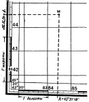
On all sides the frame has scales divided into minutes. For both latitude and longitude. Moreover, each minute is divided into 6 equal sections by dots, which correspond to 10 seconds of longitude or latitude.
Thus, in order to determine the latitude of any point M on the map, it is necessary to draw a line through this point, parallel to the lower or upper frame of the map, and read the corresponding degrees, minutes, seconds on the right or left along the latitude scale. In our example, point M has a latitude of 45°31’30”.
Similarly, drawing a vertical line through point M parallel to the lateral (closest to this point) meridian of the border of a given map sheet, we read the longitude (eastern) equal to 43°31’18”.
Drawing a point on a topographic map at specified geographic coordinates.
Drawing a point on a map at specified geographic coordinates is done in the reverse order. First, the indicated geographic coordinates are found on the scales, and then parallel and perpendicular lines are drawn through them. Their intersection will show a point with the given geographic coordinates.
Based on materials from the book “Map and Compass are My Friends.”
Klimenko A.I.
Counted from 0° to 90° on both sides of the equator. The geographic latitude of points located in the northern hemisphere (northern latitude) is usually considered positive, the latitude of points in the southern hemisphere is considered negative. It is customary to speak of latitudes close to the poles as high, and about those close to the equator - as about low.
Due to the difference in the shape of the Earth from a sphere, the geographic latitude of points differs somewhat from their geocentric latitude, that is, from the angle between the direction to a given point from the center of the Earth and the plane of the equator.
Longitude
Longitude- angle λ between the plane of the meridian passing through a given point and the plane of the initial prime meridian from which longitude is measured. Longitudes from 0° to 180° east of the prime meridian are called eastern, and to the west - western. Eastern longitudes are considered to be positive, western longitudes are considered negative.
Height
To completely determine the position of a point in three-dimensional space, a third coordinate is needed - height. The distance to the center of the planet is not used in geography: it is convenient only when describing very deep regions of the planet or, on the contrary, when calculating orbits in space.
Within the geographic envelope, the “height above sea level” is usually used, measured from the level of the “smoothed” surface - the geoid. Such a three-coordinate system turns out to be orthogonal, which simplifies a number of calculations. Altitude above sea level is also convenient because it is related to atmospheric pressure.
Distance from the earth's surface (up or down) is often used to describe a place, however Not serves coordinate
Geographic coordinate system
The main disadvantage in the practical application of the GSK in navigation is the large angular velocity of this system at high latitudes, increasing to infinity at the pole. Therefore, instead of the GSK, a semi-free CS in azimuth is used.
Semi-free in azimuth coordinate system
The azimuth-semi-free CS differs from the GSK in only one equation, which has the form:
Accordingly, the system also has the initial position that the GCS and their orientation also coincide with the only difference that its axes and are deviated from the corresponding axes of the GCS by an angle for which the equation is valid
The conversion between the GSK and the semi-free CS in azimuth is carried out according to the formula
In reality, all calculations are carried out in this system, and then, to produce output information, the coordinates are converted into the GSK.
Geographic coordinate recording formats
The WGS84 system is used to record geographic coordinates.
Coordinates (latitude from -90° to +90°, longitude from -180° to +180°) can be written:
- in ° degrees as a decimal (modern version)
- in ° degrees and "minutes with decimal fraction
- in ° degrees, "minutes and" seconds with decimal fraction (historical form of notation)
The decimal separator is always a dot. Positive coordinate signs are represented by a (in most cases omitted) "+" sign, or by the letters: "N" - north latitude and "E" - east longitude. Negative coordinate signs are represented either by a “-” sign or by the letters: “S” is south latitude and “W” is west longitude. Letters can be placed either in front or behind.
There are no uniform rules for recording coordinates.
Search engine maps by default show coordinates in degrees and decimals, with "-" signs for negative longitude. On Google maps and Yandex maps, latitude comes first, then longitude (until October 2012, the reverse order was adopted on Yandex maps: first longitude, then latitude). These coordinates are visible, for example, when plotting routes from arbitrary points. Other formats are also recognized when searching.
In navigators, by default, degrees and minutes with a decimal fraction with a letter designation are often shown, for example, in Navitel, in iGO. You can enter coordinates in accordance with other formats. The degrees and minutes format is also recommended for maritime radio communications.
At the same time, the original method of recording with degrees, minutes and seconds is often used. Currently, coordinates can be written in one of many ways or duplicated in two main ways (with degrees and with degrees, minutes and seconds). As an example, options for recording the coordinates of the sign “Zero kilometer of highways of the Russian Federation” - 55.755831 , 37.617673 55°45′20.99″ n. w. 37°37′03.62″ E. d. / 55.755831 , 37.617673 (G) (O) (I):
- 55.755831°, 37.617673° -- degrees
- N55.755831°, E37.617673° -- degrees (+ additional letters)
- 55°45.35"N, 37°37.06"E -- degrees and minutes (+ additional letters)
- 55°45"20.9916"N, 37°37"3.6228"E -- degrees, minutes and seconds (+ additional letters)
Links
- Geographic coordinates of all cities on Earth (English)
- Geographic coordinates of populated areas on Earth (1) (English)
- Geographic coordinates of populated areas on Earth (2) (English)
- Converting coordinates from degrees to degrees/minutes, to degrees/minutes/seconds and back
- Converting coordinates from degrees to degrees/minutes/seconds and back
see also
Notes
Wikimedia Foundation. 2010.
See what “Geographic coordinates” are in other dictionaries:
See Coordinates. Mountain encyclopedia. M.: Soviet Encyclopedia. Edited by E. A. Kozlovsky. 1984 1991 … Geological encyclopedia
- (latitude and longitude), determine the position of a point on the earth’s surface. Geographic latitude j is the angle between the plumb line at a given point and the plane of the equator, measured from 0 to 90 latitude on both sides of the equator. Geographical longitude l angle… … Modern encyclopedia
Latitude and longitude determine the position of a point on the earth's surface. Geographic latitude? the angle between the plumb line at a given point and the plane of the equator, measured from 0 to 90. in both directions from the equator. Geographic longitude? angle between... ... Big Encyclopedic Dictionary
Angular values that determine the position of a point on the Earth’s surface: latitude – the angle between the plumb line at a given point and the plane of the earth’s equator, measured from 0 to 90° (north of the equator is northern latitude and south of southern latitude); longitude... ...Nautical Dictionary
Video lesson “Geographical latitude and geographic longitude. Geographic Coordinates" will help you get an idea of geographic latitude and geographic longitude. The teacher will tell you how to correctly determine geographic coordinates.
Geographic latitude- arc length in degrees from the equator to a given point.
To determine the latitude of an object, you need to find the parallel on which this object is located.
For example, the latitude of Moscow is 55 degrees and 45 minutes north latitude, it is written like this: Moscow 55°45" N; latitude of New York - 40°43" N; Sydney - 33°52" S
Geographic longitude is determined by meridians. Longitude can be western (from the 0 meridian to the west to the 180 meridian) and eastern (from the 0 meridian to the east to the 180 meridian). Longitude values are measured in degrees and minutes. Geographic longitude can have values from 0 to 180 degrees.
Geographic longitude- length of the equatorial arc in degrees from the prime meridian (0 degrees) to the meridian of a given point.
The prime meridian is considered to be the Greenwich meridian (0 degrees).

Rice. 2. Determination of longitudes ()
To determine longitude, you need to find the meridian on which a given object is located.
For example, the longitude of Moscow is 37 degrees and 37 minutes east longitude, it is written like this: 37°37" east; the longitude of Mexico City is 99°08" west.

Rice. 3. Geographical latitude and geographic longitude
To accurately determine the location of an object on the surface of the Earth, you need to know its geographic latitude and geographic longitude.
Geographical coordinates- quantities that determine the position of a point on the earth’s surface using latitudes and longitudes.
For example, Moscow has the following geographic coordinates: 55°45"N and 37°37"E. The city of Beijing has the following coordinates: 39°56′ N. 116°24′ E First the latitude value is recorded.
Sometimes you need to find an object at already given coordinates; to do this, you must first guess in which hemispheres the object is located.
Homework
Paragraphs 12, 13.
1. What are geographic latitude and longitude?
Bibliography
Main
1. Basic course in geography: Textbook. for 6th grade. general education institutions / T.P. Gerasimova, N.P. Neklyukova. - 10th ed., stereotype. - M.: Bustard, 2010. - 176 p.
2. Geography. 6th grade: atlas. - 3rd ed., stereotype. - M.: Bustard, DIK, 2011. - 32 p.
3. Geography. 6th grade: atlas. - 4th ed., stereotype. - M.: Bustard, DIK, 2013. - 32 p.
4. Geography. 6th grade: cont. cards. - M.: DIK, Bustard, 2012. - 16 p.
Encyclopedias, dictionaries, reference books and statistical collections
1. Geography. Modern illustrated encyclopedia / A.P. Gorkin. - M.: Rosman-Press, 2006. - 624 p.
Literature for preparing for the State Exam and the Unified State Exam
1. Geography: initial course. Tests. Textbook manual for 6th grade students. - M.: Humanite. ed. VLADOS center, 2011. - 144 p.
2. Tests. Geography. 6-10 grades: Educational and methodological manual / A.A. Letyagin. - M.: LLC "Agency "KRPA "Olympus": "Astrel", "AST", 2001. - 284 p.
Materials on the Internet
1. Federal Institute of Pedagogical Measurements ().
2. Russian Geographical Society ().
For determining latitude It is necessary, using a triangle, to lower the perpendicular from point A to the degree frame onto the line of latitude and read the corresponding degrees, minutes, seconds on the right or left along the latitude scale. φА= φ0+ Δφ
φА=54 0 36 / 00 // +0 0 01 / 40 //= 54 0 37 / 40 //
For determining longitude you need to use a triangle to lower a perpendicular from point A to the degree frame of the line of longitude and read the corresponding degrees, minutes, seconds from above or below.
Determining the rectangular coordinates of a point on the map
The rectangular coordinates of the point (X, Y) on the map are determined in the square of the kilometer grid as follows: 
1. Using a triangle, perpendiculars are lowered from point A to the kilometer grid line X and Y and the values are taken XA=X0+Δ X; UA=U0+Δ U
For example, the coordinates of point A are: XA = 6065 km + 0.55 km = 6065.55 km;
UA = 4311 km + 0.535 km = 4311.535 km. (the coordinate is reduced);
Point A is located in the 4th zone, as indicated by the first digit of the coordinate at given.
9. Measuring the lengths of lines, directional angles and azimuths on the map, determining the angle of inclination of the line specified on the map.
Measuring lengths
To determine on a map the distance between terrain points (objects, objects), using a numerical scale, you need to measure on the map the distance between these points in centimeters and multiply the resulting number by the scale value. 
A small distance is easier to determine using a linear scale. To do this, it is enough to apply a measuring compass, the opening of which is equal to the distance between given points on the map, to a linear scale and take a reading in meters or kilometers. 
To measure curves, the “step” of the measuring compass is set so that it corresponds to an integer number of kilometers, and an integer number of “steps” is plotted on the segment measured on the map. The distance that does not fit into the whole number of “steps” of the measuring compass is determined using a linear scale and added to the resulting number of kilometers.
Measuring directional angles and azimuths on a map
.

We connect points 1 and 2. We measure the angle. The measurement is carried out using a protractor, it is located parallel to the median, then the angle of inclination is reported clockwise.
Determining the angle of inclination of a line specified on the map.
The determination follows exactly the same principle as finding the directional angle.
10. Direct and inverse geodetic problem on a plane. When performing computational processing of measurements taken on the ground, as well as when designing engineering structures and making calculations to transfer projects into reality, the need arises to solve direct and inverse geodetic problems. Direct geodetic problem . By known coordinates X 1 and at 1 point 1, directional angle 1-2 and distance d 1-2 to point 2 you need to calculate its coordinates X 2 ,at 2 .
|
|
Rice. 3.5. To the solution of direct and inverse geodetic problems |

The coordinates of point 2 are calculated using the formulas (Fig. 3.5): (3.4) where X,atcoordinate increments equal to
![]() (3.5)
(3.5)
Inverse geodetic problem .
By known coordinates X 1 ,at 1 points 1 and X 2 ,at 2 points 2 need to calculate the distance between them d 1-2 and directional angle 1-2. From formulas (3.5) and Fig. 3.5 it is clear that. (3.6) To determine the directional angle 1-2, we use the arctangent function. At the same time, we take into account that computer programs and microcalculators give the main value of the arctangent=  , lying in the range90+90, while the desired directional anglecan have any value in the range 0360.
The formula for transition from kdepends on the coordinate quarter in which the given direction is located or, in other words, on the signs of the differences y=y 2 y 1 and x=X 2 X 1 (see table 3.1 and figure 3.6). Table 3.1

Rice. 3.6. Directional angles and main arctangent values in the I, II, III and IV quarters
The distance between points is calculated using the formula
(3.6) or in another way - according to the formulas ![]() (3.7)
(3.7)
In particular, electronic tacheometers are equipped with programs for solving direct and inverse geodetic problems, which makes it possible to directly determine the coordinates of observed points during field measurements and calculate angles and distances for alignment work.
Each point on the planet's surface has a specific position, which corresponds to its own latitude and longitude coordinates. It is located at the intersection of the spherical arcs of the meridian, which corresponds to longitude, with the parallel, which corresponds to latitude. It is denoted by a pair of angular quantities expressed in degrees, minutes, seconds, which has the definition of a coordinate system.
Latitude and longitude are the geographic aspect of a plane or sphere translated into topographic images. To more accurately locate a point, its altitude above sea level is also taken into account, which makes it possible to find it in three-dimensional space.
The need to find a point using latitude and longitude coordinates arises due to the duty and occupation of rescuers, geologists, military personnel, sailors, archaeologists, pilots and drivers, but it may also be necessary for tourists, travelers, seekers, and researchers.
What is latitude and how to find it
Latitude is the distance from an object to the equator line. Measured in angular units (such as degrees, degrees, minutes, seconds, etc.). Latitude on a map or globe is indicated by horizontal parallels - lines that describe a circle parallel to the equator and converge in the form of a series of tapering rings towards the poles.

Therefore, they distinguish between northern latitude - this is the entire part of the earth's surface north of the equator, and also southern latitude - this is the entire part of the planet's surface south of the equator. The equator is the zero, longest parallel. 
- Parallels from the equator line to the north pole are considered to be a positive value from 0° to 90°, where 0° is the equator itself, and 90° is the top of the north pole. They are counted as northern latitude (N).
- Parallels extending from the equator towards the south pole are indicated by a negative value from 0° to -90°, where -90° is the location of the south pole. They are counted as southern latitude (S).
- On the globe, parallels are depicted as circles encircling the ball, which become smaller as they approach the poles.
- All points on the same parallel will be designated by the same latitude, but different longitudes.
On maps, based on their scale, parallels have the form of horizontal, curved stripes - the smaller the scale, the straighter the parallel strip is depicted, and the larger it is, the more curved it is.
Remember! The closer to the equator a given area is located, the smaller its latitude will be.
What is longitude and how to find it
Longitude is the amount by which the position of a given area is removed relative to Greenwich, that is, the prime meridian.

Longitude is similarly characterized by measurement in angular units, only from 0° to 180° and with a prefix - eastern or western. 
- The Greenwich Prime Meridian vertically encircles the globe of the Earth, passing through both poles, dividing it into the western and eastern hemispheres.
- Each of the parts located west of Greenwich (in the Western Hemisphere) will be designated west longitude (w.l.).
- Each of the parts distant from Greenwich to the east and located in the eastern hemisphere will bear the designation east longitude (E.L.).
- Finding each point along one meridian has the same longitude, but different latitude.
- Meridians are drawn on maps in the form of vertical stripes curved in the shape of an arc. The smaller the map scale, the straighter the meridian strip will be.
How to find the coordinates of a given point on the map
Often you have to find out the coordinates of a point that is located on the map in a square between the two nearest parallels and meridians. Approximate data can be obtained by eye by sequentially estimating the step in degrees between the mapped lines in the area of interest, and then comparing the distance from them to the desired area. For accurate calculations you will need a pencil with a ruler, or a compass. 
- For the initial data we take the designations of the parallels closest to our point with the meridian.
- Next, we look at the step between their stripes in degrees.
- Then we look at the size of their step on the map in cm.
- We measure with a ruler in cm the distance from a given point to the nearest parallel, as well as the distance between this line and the neighboring one, convert it to degrees and take into account the difference - subtracting from the larger one, or adding to the smaller one.
- This gives us the latitude.
Example! The distance between the parallels 40° and 50°, among which our area is located, is 2 cm or 20 mm, and the step between them is 10°. Accordingly, 1° is equal to 2 mm. Our point is 0.5 cm or 5 mm away from the fortieth parallel. We find the degrees to our area 5/2 = 2.5°, which must be added to the value of the nearest parallel: 40° + 2.5° = 42.5° - this is our northern latitude of the given point. In the southern hemisphere, the calculations are similar, but the result has a negative sign.
Similarly, we find longitude - if the nearest meridian is further from Greenwich, and the given point is closer, then we subtract the difference, if the meridian is closer to Greenwich, and the point is further, then we add it.
If you only have a compass at hand, then each of the segments is fixed with its tips, and the spread is transferred to the scale.
In a similar way, calculations of coordinates on the surface of the globe are carried out.