Consists of many layers piled on top of each other. However, what we know best is the earth's crust and lithosphere. This is not surprising - after all, we not only live on them, but also draw from the depths most of the natural resources available to us. But the upper shells of the Earth still preserve millions of years of history of our planet and the entire solar system.
These two concepts appear so often in the press and literature that they have entered the everyday vocabulary of modern man. Both words are used to refer to the surface of the Earth or another planet - however, there is a difference between the concepts, based on two fundamental approaches: chemical and mechanical.
Chemical aspect - earth's crust
If you divide the Earth into layers based on differences in chemical composition, the top layer of the planet will be the earth's crust. This is a relatively thin shell, ending at a depth of 5 to 130 kilometers below sea level - the oceanic crust is thinner, and the continental crust, in mountainous areas, is thickest. Although 75% of the crust's mass is composed only of silicon and oxygen (not pure, bound in different substances), it has the greatest chemical diversity of all layers of the Earth.
The wealth of minerals also plays a role - various substances and mixtures created over billions of years of the planet’s history. The Earth's crust contains not only "native" minerals that were created by geological processes, but also massive organic heritage, such as oil and coal, as well as alien inclusions.
Physical aspect - lithosphere
Based on the physical characteristics of the Earth, such as hardness or elasticity, we will get a slightly different picture - the interior of the planet will be enveloped by the lithosphere (from the Greek lithos, “rocky, hard” and “sphaira” sphere). It is much thicker than the earth's crust: the lithosphere extends up to 280 kilometers deep and even covers the upper solid part of the mantle!
The characteristics of this shell fully correspond to the name - it is the only solid layer of the Earth, besides the inner core. Strength, however, is relative - the Earth's lithosphere is one of the most mobile in the solar system, which is why the planet has changed its appearance more than once. But significant compression, curvature and other elastic changes require thousands of years, if not more.

- An interesting fact is that the planet may not have a surface crust. So, the surface is its hardened mantle; The planet closest to the Sun lost its crust a long time ago as a result of numerous collisions.
To summarize, the Earth's crust is the upper, chemically diverse part of the lithosphere, the hard shell of the Earth. Initially they had almost the same composition. But when only the underlying asthenosphere and high temperatures affected the depths, the hydrosphere, atmosphere, meteorite remains and living organisms actively participated in the formation of minerals on the surface.
Lithospheric plates
Another feature that distinguishes the Earth from other planets is the diversity of different types of landscapes on it. Of course, water also played an incredibly important role, which we will talk about a little later. But even the basic forms of the planetary landscape of our planet differ from the same Moon. The seas and mountains of our satellite are pits from bombardment by meteorites. And on Earth they were formed as a result of hundreds and thousands of millions of years of movement of lithospheric plates.
You've probably already heard about plates - these are huge stable fragments of the lithosphere that drift along the fluid asthenosphere, like broken ice on a river. However, there are two main differences between the lithosphere and ice:
- The gaps between the plates are small and are quickly closed due to the molten substance erupting from them, and the plates themselves are not destroyed by collisions.
- Unlike water, there is no constant flow in the mantle, which could set a constant direction for the movement of the continents.
Thus, the driving force behind the drift of lithospheric plates is the convection of the asthenosphere, the main part of the mantle - hotter flows from the earth's core rise to the surface when cold ones fall back down. Considering that the continents differ in size, and the topography of their lower side mirrors the irregularities of the upper side, they also move unevenly and inconsistently.

Main plates
Over billions of years of movement of lithospheric plates, they repeatedly merged into supercontinents, after which they separated again. In the near future, in 200–300 million years, the formation of a supercontinent called Pangea Ultima is also expected. We recommend watching the video at the end of the article - it clearly shows how lithospheric plates have migrated over the past several hundred million years. In addition, the strength and activity of continental movement is determined by the internal heating of the Earth - the higher it is, the more the planet expands, and the faster and freer the lithospheric plates move. However, since the beginning of the Earth's history, its temperature and radius have been gradually decreasing.
- An interesting fact is that plate drift and geological activity do not necessarily have to be powered by the internal self-heating of the planet. For example, the satellite of Jupiter has many active volcanoes. But the energy for this is not provided by the satellite’s core, but by gravitational friction c, due to which Io’s interior heats up.
The boundaries of lithospheric plates are very arbitrary - some parts of the lithosphere sink under others, and some, like the Pacific plate, are completely hidden under water. Geologists today count 8 main plates that cover 90 percent of the entire Earth's area:
- Australian
- Antarctic
- African
- Eurasian
- Hindustan
- Pacific
- North American
- South American

Such a division appeared recently - for example, the Eurasian plate, 350 million years ago, consisted of separate parts, during the merger of which the Ural Mountains, one of the oldest on Earth, were formed. Scientists to this day continue to study faults and the ocean floor, discovering new plates and clarifying the boundaries of old ones.
Geological activity
Lithospheric plates move very slowly - they creep over each other at a speed of 1–6 cm/year, and move away by a maximum of 10–18 cm/year. But it is the interaction between the continents that creates the geological activity of the Earth, noticeable on the surface - volcanic eruptions, earthquakes and the formation of mountains always occur in the contact zones of lithospheric plates.
However, there are exceptions - so-called hot spots, which can also exist deep in lithospheric plates. In them, molten flows of asthenosphere matter break upward, melting the lithosphere, which leads to increased volcanic activity and regular earthquakes. Most often, this happens near those places where one lithospheric plate creeps onto another - the lower, depressed part of the plate sinks into the Earth's mantle, thereby increasing the pressure of magma on the upper plate. However, now scientists are inclined to believe that the “drowned” parts of the lithosphere are melting, increasing pressure in the depths of the mantle and thereby creating upward flows. This can explain the anomalous distance of some hot spots from tectonic faults.

- An interesting fact is that shield volcanoes, characterized by their flat shape, often form in hot spots. They erupt many times, growing due to flowing lava. This is also a typical alien volcano format. The most famous of them is on Mars, the highest point on the planet - its height reaches 27 kilometers!
Oceanic and continental crust of the Earth
Plate interactions also result in the formation of two different types of crust - oceanic and continental. Since the oceans, as a rule, are the junctions of different lithospheric plates, their crust is constantly changing - being broken or absorbed by other plates. At the site of faults, direct contact occurs with the mantle, from where hot magma rises. As it cools under the influence of water, it creates a thin layer of basalts, the main volcanic rock. Thus, the oceanic crust is completely renewed every 100 million years - the oldest areas, which are located in the Pacific Ocean, reach a maximum age of 156–160 million years.
Important! The oceanic crust is not all of the earth’s crust that is under water, but only its young sections at the junction of continents. Part of the continental crust is under water, in the zone of stable lithospheric plates.

Age of oceanic crust (red corresponds to young crust, blue to old crust).
According to modern plate theories The entire lithosphere is divided into separate blocks by narrow and active zones - deep faults - moving in the plastic layer of the upper mantle relative to each other at a speed of 2-3 cm per year. These blocks are called lithospheric plates.
The peculiarity of lithospheric plates is their rigidity and ability, in the absence of external influences, to maintain their shape and structure unchanged for a long time.
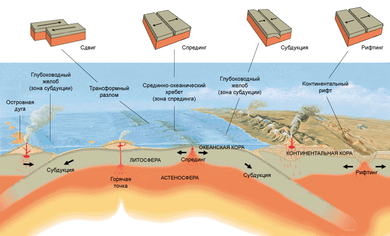
Lithospheric plates are mobile. Their movement along the surface of the asthenosphere occurs under the influence of convective currents in the mantle. Individual lithospheric plates can move apart, move closer together, or slide relative to each other. In the first case, tension zones with cracks along the boundaries of the plates appear between the plates, in the second - compression zones, accompanied by the pushing of one plate onto another (thrusting - obduction; thrusting - subduction), in the third - shear zones - faults along which sliding of neighboring plates occurs .
Where continental plates converge, they collide and mountain belts are formed. This is how, for example, the Himalaya mountain system arose on the border of the Eurasian and Indo-Australian plates (Fig. 1).
Rice. 1. Collision of continental lithospheric plates
When the continental and oceanic plates interact, the plate with the oceanic crust moves under the plate with the continental crust (Fig. 2).

Rice. 2. Collision of continental and oceanic lithospheric plates
As a result of the collision of continental and oceanic lithospheric plates, deep-sea trenches and island arcs are formed.
The divergence of lithospheric plates and the resulting formation of the oceanic crust is shown in Fig. 3.

The axial zones of mid-ocean ridges are characterized by rifts(from English rift - crevice, crack, fault) - a large linear tectonic structure of the earth's crust hundreds, thousands in length, tens and sometimes hundreds of kilometers wide, formed mainly during horizontal stretching of the crust (Fig. 4). Very large rifts are called rift belts, zones or systems.
Since the lithospheric plate is a single plate, each of its faults is a source of seismic activity and volcanism. These sources are concentrated within relatively narrow zones along which mutual movements and friction of adjacent plates occur. These zones are called seismic belts. Reefs, mid-ocean ridges and deep-sea trenches are mobile regions of the Earth and are located at the boundaries of lithospheric plates. This indicates that the process of formation of the earth's crust in these zones is currently occurring very intensively.

Rice. 3. Divergence of lithospheric plates in the zone among the oceanic ridge

Rice. 4. Rift formation scheme
Most of the faults of lithospheric plates occur at the bottom of the oceans, where the earth’s crust is thinner, but they also occur on land. The largest fault on land is located in eastern Africa. It stretches for 4000 km. The width of this fault is 80-120 km.
Currently, seven of the largest plates can be distinguished (Fig. 5). Of these, the largest in area is the Pacific, which consists entirely of oceanic lithosphere. As a rule, the Nazca plate, which is several times smaller in size than each of the seven largest ones, is also classified as large. At the same time, scientists suggest that in fact the Nazca plate is much larger than we see on the map (see Fig. 5), since a significant part of it went under neighboring plates. This plate also consists only of oceanic lithosphere.

Rice. 5. Earth's lithospheric plates
An example of a plate that includes both continental and oceanic lithosphere is, for example, the Indo-Australian lithospheric plate. The Arabian plate consists almost entirely of continental lithosphere.
The theory of lithospheric plates is important. First of all, it can explain why there are mountains in some places on Earth and plains in others. Using the theory of lithospheric plates, it is possible to explain and predict catastrophic phenomena that occur at plate boundaries.

Rice. 6. The shapes of the continents really seem compatible.
Continental drift theory
The theory of lithospheric plates originates from the theory of continental drift. Back in the 19th century. many geographers have noted that when looking at a map, one can notice that the coasts of Africa and South America seem compatible when approaching (Fig. 6).
The emergence of the hypothesis of continental movement is associated with the name of the German scientist Alfred Wegener(1880-1930) (Fig. 7), who most fully developed this idea.
Wegener wrote: “In 1910, the idea of moving continents first occurred to me... when I was struck by the similarity of the outlines of the coasts on both sides of the Atlantic Ocean.” He suggested that in the early Paleozoic there were two large continents on Earth - Laurasia and Gondwana.
Laurasia was the northern continent, which included the territories of modern Europe, Asia without India and North America. The southern continent - Gondwana united the modern territories of South America, Africa, Antarctica, Australia and Hindustan.
Between Gondwana and Laurasia there was the first sea - Tethys, like a huge bay. The rest of the Earth's space was occupied by the Panthalassa Ocean.
About 200 million years ago, Gondwana and Laurasia were united into a single continent - Pangea (Pan - universal, Ge - earth) (Fig. 8).

Rice. 8. The existence of a single continent of Pangea (white - land, dots - shallow sea)
About 180 million years ago, the continent of Pangea again began to separate into its component parts, which mixed on the surface of our planet. The division occurred as follows: first Laurasia and Gondwana reappeared, then Laurasia split, and then Gondwana split. Due to the split and divergence of parts of Pangea, oceans were formed. The Atlantic and Indian oceans can be considered young oceans; old - Quiet. The Arctic Ocean became isolated as landmass increased in the Northern Hemisphere.

Rice. 9. Location and directions of continental drift during the Cretaceous period 180 million years ago
A. Wegener found many confirmations of the existence of a single continent of the Earth. He found the existence of remains of ancient animals—listosaurus—in Africa and South America especially convincing. These were reptiles, similar to small hippopotamuses, that lived only in freshwater bodies of water. This means that they could not swim huge distances in salty sea water. He found similar evidence in the plant world.
Interest in the hypothesis of continental movement in the 30s of the 20th century. decreased somewhat, but was revived again in the 60s, when, as a result of studies of the relief and geology of the ocean floor, data were obtained indicating the processes of expansion (spreading) of the oceanic crust and the “diving” of some parts of the crust under others (subduction).
Then surely you would like to know what are lithospheric plates.
So, lithospheric plates are huge blocks into which the solid surface layer of the earth is divided. Given the fact that the rock beneath them is molten, the plates move slowly, at a speed of 1 to 10 centimeters per year.
Today there are 13 largest lithospheric plates, which cover 90% of the earth's surface.
Largest lithospheric plates:
- Australian plate- 47,000,000 km²
- Antarctic plate- 60,900,000 km²
- Arabian subcontinent- 5,000,000 km²
- African plate- 61,300,000 km²
- Eurasian plate- 67,800,000 km²
- Hindustan plate- 11,900,000 km²
- Coconut Plate - 2,900,000 km²
- Nazca Plate - 15,600,000 km²
- Pacific Plate- 103,300,000 km²
- North American Plate- 75,900,000 km²
- Somali plate- 16,700,000 km²
- South American Plate- 43,600,000 km²
- Philippine plate- 5,500,000 km²
Here it must be said that there is a continental and oceanic crust. Some plates are composed solely of one type of crust (such as the Pacific plate), and some are of mixed types, where the plate begins in the ocean and smoothly transitions to the continent. The thickness of these layers is 70-100 kilometers.
Lithospheric plates float on the surface of a partially molten layer of the earth - the mantle. When the plates move apart, liquid rock called magma fills the cracks between them. When magma solidifies, it forms new crystalline rocks. We’ll talk more about magma in the article on volcanoes.
Map of lithospheric plates
Largest lithospheric plates (13 pcs.)At the beginning of the 20th century, American F.B. Taylor and the German Alfred Wegener simultaneously came to the conclusion that the location of the continents was slowly changing. By the way, this is, to a large extent, what it is. But scientists were unable to explain how this happens until the 60s of the twentieth century, when the doctrine of geological processes on the seabed was developed.
 Map of the location of lithospheric plates
 It was fossils that played the main role here. Fossilized remains of animals that clearly could not swim across the ocean were found on different continents. This led to the assumption that once all the continents were connected and animals calmly moved between them.
Subscribe to. We have many interesting facts and fascinating stories from people's lives.
The Earth's crust is divided by faults into lithospheric plates, which are huge solid blocks that reach the upper layers of the mantle. They are large, stable parts of the earth's crust and are in continuous motion, sliding along the surface of the Earth. Lithospheric plates consist of either continental or oceanic crust, and some combine a continental massif with an oceanic one. There are 7 largest lithospheric plates, which occupy 90% of the surface of our planet: Antarctic, Eurasian, African, Pacific, Indo-Australian, South American, North American. In addition to them, there are dozens of medium-sized slabs and many small ones. Between the medium and large slabs there are belts in the form of mosaics of small slabs of bark.
Theory of plate tectonics
The theory of lithospheric plates studies their movement and the processes associated with this movement. This theory states that the cause of global tectonic changes is the horizontal movement of lithosphere blocks - plates. Plate tectonics examines the interaction and movement of blocks of the earth's crust.

Wagner's theory
The idea that lithospheric plates move horizontally was first suggested in the 1920s by Alfred Wagner. He put forward a hypothesis about “continental drift”, but it was not recognized as reliable at that time. Later, in the 1960s, studies of the ocean floor were carried out, as a result of which Wagner’s guesses about the horizontal movement of plates were confirmed, and the presence of processes of ocean expansion, caused by the formation of oceanic crust (spreading), was revealed. The main provisions of the theory were formulated in 1967-68 by American geophysicists J. Isaacs, C. Le Pichon, L. Sykes, J. Oliver, W. J. Morgan. According to this theory, plate boundaries are located in zones of tectonic, seismic and volcanic activity. Boundaries are divergent, transformative and convergent.

Movement of lithospheric plates
Lithospheric plates begin to move due to the movement of matter located in the upper mantle. In rift zones, this substance breaks through the crust, pushing plates apart. Most rifts are located on the ocean floor, since the earth's crust there is much thinner. The largest rifts that exist on land are located near Lake Baikal and the African Great Lakes. The movement of lithospheric plates occurs at a speed of 1-6 cm per year. When they collide with each other, mountain systems arise at their boundaries in the presence of continental crust, and in the case when one of the plates has a crust of oceanic origin, deep-sea trenches are formed.
The basic principles of plate tectonics come down to several points.
- In the upper rocky part of the Earth, there are two shells that differ significantly in geological characteristics. These shells are the hard and brittle lithosphere and the mobile asthenosphere underneath. The base of the lithosphere is a hot isotherm with a temperature of 1300°C.
- The lithosphere consists of plates of the earth's crust continuously moving along the surface of the asthenosphere.
There are two types of lithosphere. The oceanic lithosphere has oceanic crust about 6 km thick. It is mostly covered by the sea. The continental lithosphere is covered by continental crust with a thickness of 35 to 70 km. Most of this crust protrudes above, forming land.
Plates
Rocks and minerals
Moving plates
The plates of the earth's crust are constantly moving in different directions, although very slowly. The average speed of their movement is 5 cm per year. Your nails grow at about the same rate. Since all the plates fit tightly together, the movement of any one of them affects the surrounding plates, causing them to gradually move. Plates can move in different ways, which can be seen at their boundaries, but the reasons that cause plate movement are still unknown to scientists. Apparently, this process may have neither beginning nor end. Nevertheless, some theories claim that one type of plate movement can be, so to speak, “primary”, and from it all other plates begin to move.
One type of plate movement is the “diving” of one plate under another. Some scholars believe that it is this type of movement that causes all other plate movements. At some boundaries, molten rock pushing up to the surface between two plates solidifies at their edges, pushing the plates apart. This process can also cause all the other plates to move. It is also believed that, in addition to the primary shock, the movement of plates is stimulated by giant heat flows circulating in the mantle (see article ““).
Drifting continents
Scientists believe that since the formation of the primary earth's crust, the movement of plates has changed the position, shape and size of continents and oceans. This process was called tectonics slabs. Various proofs of this theory are given. For example, the outlines of continents such as South America and Africa look as if they once formed a single whole. Undoubted similarities were also discovered in the structure and age of the rocks that make up the ancient mountain ranges on both continents.
1. According to scientists, the land masses that now form South America and Africa were connected to each other more than 200 million years ago.
2. Apparently, the floor of the Atlantic Ocean gradually expanded as new rock formed at plate boundaries.
3. Currently, South America and Africa are moving away from each other at a rate of about 3.5 cm per year due to plate movement.