There are many different coordinate systems, all of which are used to determine the position of points on the earth's surface. These include mainly geographic coordinates, plane rectangular and polar coordinates. In general, coordinates are usually called angular and linear quantities that define points on any surface or in space.
Geographic coordinates are angular values - latitude and longitude - that determine the position of a point on the globe. Geographic latitude is the angle formed by the equatorial plane and a plumb line at a given point on the earth's surface. This angle value shows how far a particular point on the globe is north or south of the equator.
If a point is located in the Northern Hemisphere, then its geographic latitude will be called northern, and if in the Southern Hemisphere - southern latitude. The latitude of points located on the equator is zero degrees, and at the poles (North and South) - 90 degrees.
Geographic longitude is also an angle, but formed by the plane of the meridian, taken as the initial (zero), and the plane of the meridian passing through a given point. For uniformity of definition, we agreed to consider the prime meridian to be the meridian passing through the astronomical observatory in Greenwich (near London) and call it Greenwich.
All points located to the east of it will have eastern longitude (up to the meridian 180 degrees), and to the west of the initial one will have western longitude. The figure below shows how to determine the position of point A on the earth's surface if its geographic coordinates (latitude and longitude) are known.
Note that the difference in longitude of two points on Earth shows not only their relative position in relation to the prime meridian, but also the difference in these points at the same moment. The fact is that every 15 degrees (24th part of the circle) in longitude is equal to one hour of time. Based on this, it is possible to determine the time difference at these two points using geographic longitude.
For example.
Moscow has a longitude of 37°37′ (east), and Khabarovsk -135°05′, that is, lies east of 97°28′. What time do these cities have at the same moment? Simple calculations show that if it is 13 hours in Moscow, then in Khabarovsk it is 19 hours 30 minutes.
The figure below shows the design of the frame of a sheet of any card. As can be seen from the figure, in the corners of this map the longitude of the meridians and the latitude of the parallels that form the frame of the sheet of this map are written.

On all sides the frame has scales divided into minutes. For both latitude and longitude. Moreover, each minute is divided into 6 equal sections by dots, which correspond to 10 seconds of longitude or latitude.
Thus, in order to determine the latitude of any point M on the map, it is necessary to draw a line through this point, parallel to the lower or upper frame of the map, and read the corresponding degrees, minutes, seconds on the right or left along the latitude scale. In our example, point M has a latitude of 45°31’30”.
Similarly, drawing a vertical line through point M parallel to the lateral (closest to this point) meridian of the border of a given map sheet, we read the longitude (eastern) equal to 43°31’18”.
Drawing a point on a topographic map at specified geographic coordinates.
Drawing a point on a map at specified geographic coordinates is done in the reverse order. First, the indicated geographic coordinates are found on the scales, and then parallel and perpendicular lines are drawn through them. Their intersection will show a point with the given geographic coordinates.
Based on materials from the book “Map and Compass are My Friends.”
Klimenko A.I.
Video lesson “Geographical latitude and geographic longitude. Geographic Coordinates" will help you get an idea of geographic latitude and geographic longitude. The teacher will tell you how to correctly determine geographic coordinates.
Geographic latitude- arc length in degrees from the equator to a given point.
To determine the latitude of an object, you need to find the parallel on which this object is located.
For example, the latitude of Moscow is 55 degrees and 45 minutes north latitude, it is written like this: Moscow 55°45" N; latitude of New York - 40°43" N; Sydney - 33°52" S
Geographic longitude is determined by meridians. Longitude can be western (from the 0 meridian to the west to the 180 meridian) and eastern (from the 0 meridian to the east to the 180 meridian). Longitude values are measured in degrees and minutes. Geographic longitude can have values from 0 to 180 degrees.
Geographic longitude- length of the equatorial arc in degrees from the prime meridian (0 degrees) to the meridian of a given point.
The prime meridian is considered to be the Greenwich meridian (0 degrees).

Rice. 2. Determination of longitudes ()
To determine longitude, you need to find the meridian on which a given object is located.
For example, the longitude of Moscow is 37 degrees and 37 minutes east longitude, it is written like this: 37°37" east; the longitude of Mexico City is 99°08" west.

Rice. 3. Geographical latitude and geographic longitude
To accurately determine the location of an object on the surface of the Earth, you need to know its geographic latitude and geographic longitude.
Geographical coordinates- quantities that determine the position of a point on the earth’s surface using latitudes and longitudes.
For example, Moscow has the following geographic coordinates: 55°45"N and 37°37"E. The city of Beijing has the following coordinates: 39°56′ N. 116°24′ E First the latitude value is recorded.
Sometimes you need to find an object at already given coordinates; to do this, you must first guess in which hemispheres the object is located.
Homework
Paragraphs 12, 13.
1. What are geographic latitude and longitude?
Bibliography
Main
1. Basic course in geography: Textbook. for 6th grade. general education institutions / T.P. Gerasimova, N.P. Neklyukova. - 10th ed., stereotype. - M.: Bustard, 2010. - 176 p.
2. Geography. 6th grade: atlas. - 3rd ed., stereotype. - M.: Bustard, DIK, 2011. - 32 p.
3. Geography. 6th grade: atlas. - 4th ed., stereotype. - M.: Bustard, DIK, 2013. - 32 p.
4. Geography. 6th grade: cont. cards. - M.: DIK, Bustard, 2012. - 16 p.
Encyclopedias, dictionaries, reference books and statistical collections
1. Geography. Modern illustrated encyclopedia / A.P. Gorkin. - M.: Rosman-Press, 2006. - 624 p.
Literature for preparing for the State Exam and the Unified State Exam
1. Geography: initial course. Tests. Textbook manual for 6th grade students. - M.: Humanite. ed. VLADOS center, 2011. - 144 p.
2. Tests. Geography. 6-10 grades: Educational and methodological manual / A.A. Letyagin. - M.: LLC "Agency "KRPA "Olympus": "Astrel", "AST", 2001. - 284 p.
Materials on the Internet
1. Federal Institute of Pedagogical Measurements ().
2. Russian Geographical Society ().
Instructions
First you must determine geographic longitude. This value is the deviation of an object from the prime meridian, from 0° to 180°. If the desired point is east of Greenwich, the value is called east longitude, if west - longitude. One degree is equal to 1/360 part.
Pay attention to the fact that in one hour the Earth rotates by 15° of longitude, and in four minutes it moves by 1°. Your watch must show accurate time. To find geographic longitude, you need to set the time to noon.
Find a straight stick 1-1.5 meters long. Stick it vertically into the ground. As soon as the shadow from the stick falls from south to north, and the sundial “shows” 12 o’clock, note the time. This is local noon. Convert the received data to Greenwich Time.
Subtract 12 from the result obtained. Convert this difference to degrees. This method does not give 100% results, and the longitude from your calculations may differ from the true geographic longitude of your location by 0°-4°.
Remember, if local noon occurs earlier than noon GMT, this is longitude; if later, it is . Now you must set the geographic latitude. This value shows the deviation of an object from the equator to the north (north latitude) or south (latitude) side, from 0° to 90°.
Please note that the length of one geographic degree is approximately 111.12 km. To determine the geographic latitude, you need to wait until nightfall. Prepare a protractor and point its lower part (base) at the polar star.
Place the protractor upside down, but so that the zero degree is opposite the polar star. Look at what degree the hole in the middle of the protractor is opposite. This will be the geographic latitude.
Sources:
- Determining latitude and longitude
- how to determine location coordinates
With the development of interregional labor relations, as well as for personal interests, the need arises to move from city to city, other populated areas, or to places where you have never been before. There are now many ways to determine coordinates desired destination.
Instructions
Start installing the downloaded file by clicking the “install” button and wait for the program to download.
Select a starting location and check the box.
Also define coordinates You can use Bing.com.
Enter the area you are interested in in the fields opposite the logo and click search.
Right-click on Directions from here and a window will appear on the left side. Indicate your destination area. Red flag is the starting area, green flag is the destination area. There on the left side, select how you would like to get there.
Find the elevation angle using the set screw and Vernier scale.
Globes and maps have their own coordinate system. Thanks to this, any object on our planet can be applied to them and found. Geographic coordinates are longitude and latitude; these angular values are measured in degrees. With their help, you can determine the position of an object on the surface of our planet relative to the prime meridian and equator.

Instructions
Having determined local noon, note the clock readings. Then make an adjustment to the resulting difference. The fact is that the angular speed of movement is not constant and depends on the time of year. So add (or subtract) an amendment to the result obtained.
Let's look at an example. Let's say today is May 2. The clocks are set according to Moscow. In summer, Moscow summer time differs from world time by 4 hours. At local noon, as determined by the sundial, the clock showed 18:36. Thus, world time is currently 14:35. Subtract 12 hours from this time and get 02:36. The amendment for May 2 is 3 minutes (this time should be added). Converting the obtained result into an angular measure, we obtain 39 degrees west longitude. The described method allows us to determine it with an accuracy of up to three degrees. Considering that in an emergency you will not have a table of the equation of time at hand to make adjustments to the calculations, the result may differ from the true one.
To determine geographic latitude, you will need a protractor and a plumb line. Make a homemade protractor from two rectangular strips, fastening them in the form of a compass.
Attach a thread with a weight in the center of the protractor (it will act as a plumb line). Point the base of the protractor at the North Star.
Subtract 90 degrees from the angle between the base of the protractor and the plumb line. We got the angle between the polar star and the horizon. Since it has a deviation from the pole axis of only one degree, the angle between the direction to the star and the horizon will be the desired latitude of the area in which you are located.
Sources:
- Determining latitude and longitude
Knowing the latitude where your home is located can be very helpful. Despite the fact that today the exact location can be easily determined using compact navigators, navigating the terrain using the “old” methods is still relevant and very interesting.

You will need
- Minimum knowledge of the starry sky, as well as:
- - two slats,
- - bolt with nut,
- - protractor
Instructions
To determine geographic latitude places, you need to make a simple protractor.
Take two rectangular wooden planks one and a half to two meters long and hinge their ends together using the principle of a compass. Stick one leg of the compass into the ground and set it vertically and plumb. The second should move quite tightly on the hinge. A bolt with can be used as a hinge.
These preliminary works must be done during the day, before dusk. Naturally, the weather must be cloudless enough to allow you to observe the starry sky.
At dusk, go out into the yard and look for the North Star in the sky.
To determine the location, find the Big Dipper. To do this, turn your face to the north and try to see the seven that form the outline of a large bucket. Usually this constellation is easy to find.
Now mentally draw a line between the two outer stars of the bucket towards the bell and measure five segments on it equal to the distance between these stars.
You will find yourself on a fairly bright star, which will be Polaris. Make sure you are not mistaken: the star found should be the end of the small dipper - the constellation Ursa Minor.
Point the movable leg of the compass strictly at the North Star. To do this, you will have to turn the device a little and again align the vertical rail in a plumb line. Now, as it were, “aim” at the star - as surveyors do - and fix the position of the device by tightening the nut on the hinge.
Now, using a protractor, measure the angle between the direction towards the star and the vertical post. This can be done in the light by moving the device indoors.
Subtract 90 from the result obtained - this will be the latitude of your place.
Video on the topic
To ensure that some object can always be found on a map or terrain, an international coordinate system was created, including latitude and longitude. Sometimes the ability to determine your coordinates can even save your life, for example, if you are lost in the forest and want to convey information about your location to rescuers. Latitude determines the angle formed by a plumb line from the equator and the desired point. If the place is located north of the equator (higher), then the latitude will be north, if south (lower) it will be south.

You will need
- - protractor and plumb line;
- - watch;
- - nomogram;
- - map;
- - a computer connected to the Internet.
Instructions
Latitude determines the angle formed by a plumb line from the desired point. If the place is located north of the equator (higher), then the latitude will be, if south (lower) - southern. To find out latitude in the field, using improvised means, take a protractor and a plumb line. If you don't have a protractor, make one from two rectangular strips, fastening them in the form of a compass so that you can change the angle between them. Attach a thread with a weight in the center, it will act as a plumb line. Point the base of the protractor at polar. Then subtract 90? from the angle between the plumb line and the protractor. Since the angular angle from the axis of the celestial pole at the polar star is only 1?, then the angle between the horizon and the polar star will be equal to space, so feel free to calculate this angle and, thus, latitude.
If you have a watch, note the length of the day between sunrise and sunset. Take the nomogram, put the resulting length of day on the left side, and mark the date on the right side. Connect the obtained values and determine the point of intersection with the part. This will be the latitude of your location.
To determine latitude according to, use horizontal lines - parallels. Look at the value on the right and left of each line. If the location you are looking for lies directly on the line, the latitude will be equal to this value. If you are looking for latitude place located between two lines, calculate approximately at what distance it is located from the nearest parallel. For example, the point is located approximately 1/3 of the parallel 30? and 2/3 of 45?. This means that approximately its latitude will be equal to 35?.
Video on the topic
Helpful advice
You can find out both the latitude and longitude of your location using a satellite navigation system, so when traveling into uncharted wilderness, be sure to take this essential item with you.
Any point on the ground has its own geographical coordinates. With the advent of GPS navigators, determining the exact location has ceased to be a problem, but the ability to understand the map - in particular, determine and longitude, is still quite relevant.

You will need
- - Globe or world map.
Instructions
The equator divides the globe into two halves: the upper, or northern, and the lower, southern. Pay attention to the parallels - ring lines encircling the globe parallel to the equator. These are the lines that define latitude. At this point it is equal to zero, and as it moves towards the poles it increases to 90°.
Find it on the globe or map your point - let's say it's Moscow. Look at what parallel it is located, you should get 55°. This means that Moscow is located at 55° latitude. Northern because it lies north of the equator. If you, for example, were looking for the coordinates of Sydney, it would be at 33° south latitude - because it lies south of the equator.
Now search for map England and its capital - London. Please note that it is through this one that one of the meridians passes - the lines stretching between the poles. The Greenwich Observatory is located near London; it is from this place that longitude is usually measured. Therefore, on which the observatory itself lies is equal to 0°. Everything that is west of Greenwich up to 180° is considered western. That which is to the east and up to 180° is to eastern longitude.
Based on the above, you can determine longitude Moscow - it is equal to 37°. In practice, to accurately indicate the location of a populated area, they determine not only , but also minutes, and sometimes . Therefore, the exact geographical coordinates of Moscow are as follows: 55 degrees 45 minutes north latitude (55°45?) and 37 degrees 37 minutes east longitude (37°38?). The geographical coordinates of the above-mentioned Sydney, which lies in the Southern Hemisphere, are 33° 52" south latitude and 151° 12" east longitude.
Because cyclamen is a rare “guest” in the garden, many gardeners are sure that it is exclusively a flower. However, cyclamen feels great in a personal plot if you give it a place in the partial shade of fruit trees or evergreen shrubs, protecting it from drafts and direct sunlight. Cyclamen is good for arranging an alpine hill. The choice of this arrangement of the flower is explained by its location in the wild, where it is found both in the forest and among the rocks.
Distribution area of cyclamens in the wild
Cyclamen is a heat-loving plant that prefers moderate humidity and shade. Therefore, most species grow in thickets of forests or bushes, as well as in rock crevices. In the territory of the former Soviet Union, cyclamens are found in Ukraine, Crimea, the southwest of the Caucasus, the south of Azerbaijan, and the Krasnodar Territory. Among the countries of Central Europe, France, Germany, Poland, and Bulgaria can boast of cyclamen habitat, where plants are mainly found in the south and southeast.
Species from these regions, or “natives” from northern Turkey, are quite suitable for cultivation in the garden conditions of the European part of Russia, especially since the eastern Mediterranean is a real cyclamen: Turkey, Iran, Syria, Cyprus, Greece, Israel. In the western Mediterranean, Italy and Spain, cyclamens also grow. On a hill near the Italian Lake Castel Kaldorf, you can observe their friendly flowering, which rarely happens in nature. After all, most wild species are on the verge of extinction. Northern Tunisia and Algeria are rich in cyclamen.
Varieties of wild cyclamens
It must be said that depending on their habitat, cyclamen have different endurance. For example, the ivy-leaved cyclamen or Neapolitan, common in central Europe, can easily overwinter in the snowy Russian winter with a temperature of -20°C. European cyclamen (purple) stands out from the general range of heat-loving species. It is characterized by a silvery leaf pattern and flowering not in the fall, like most cyclamen, but starting in June.
Sometimes they treat cyclamens growing in the territories of Abkhazia, Azerbaijan, and Adjara extremely unfairly, calling all species “Caucasian”. After all, here they distinguish such varieties as Circassian, Abkhazian, Colchian (Pontic), spring, graceful, Kosian. The latter is quite well known in Iran, Turkey, Syria, Israel and Bulgaria. Prefers to grow among coniferous vegetation. Its flowers are larger the further to the east. The largest flowers are considered to be cyclamen Kos on the shores of the Caspian Sea, in Azerbaijan.
In the south of France and the mountainous regions of Spain, a small species of cyclamen is common - Balearic, which belongs to the spring-flowering species. African cyclamen is considered the most heat-loving, its distinctive features are bright green large leaves that appear on the surface after the flowers. You can guess the habitat of many types of cyclamen by their name: African cyclamen, Cypriot cyclamen, Grecum, Persian. Persian, like African, does not tolerate even mild frosts.
The Russian name for rowan comes from the word “ripple”. Most likely, this is due to the fact that its clusters are bright and noticeable even from afar. But this name refers only to trees with red and yellow fruits. The widespread black rowan has a completely different scientific name - chokeberry, although it also belongs to the Rosaceae family.
Rowan is a unique tree that has an extensive root system, which allows it to grow in a variety of latitudes, even in permafrost conditions, and withstand frosts down to -50 degrees Celsius. As a rule, the height of rowan is about 4–5 m, but in mild climates there are specimens reaching 15 m in height. In cold and harsh areas it does not grow higher than 50 cm.
Rowan belongs to fruit trees, but its fruits are not berries at all, as is commonly believed, but so-called false drupes. They have an oval-round shape and a core with seeds, so their structure is similar to an apple, only much smaller in size. Rowan begins to bear fruit when it reaches the age of 7 - 8 years, and is often long-lived - some trees live up to 200 years. Rowan, growing for more than 20 years, can produce a harvest of over 100 kg per year.
Places of distribution
Various varieties and hybrids of rowan are widespread throughout Europe, Asia, and North America. The most common species in our latitudes is the mountain ash (Sorbus aucuparia), which grows in abundance in gardens and forests almost throughout Russia and does not require any special care. Its most popular forms are considered to be Nevezhin rowan and yellow-fruited rowan. In the southern, southwestern, and less often in the middle regions of Russia, Crimean large-fruited rowan (Sorbus domestica), which is also called domestic, is bred. The peculiarity of this species is its large pear-shaped fruits, reaching 3.5 cm in diameter and 20 g in weight, which have a particularly pleasant taste due to their high sugar content (about 14%).Rowan grows everywhere throughout the forest and forest-steppe zones of the European part of Russia (with the exception, perhaps, of the Far North), in the wooded regions of the Crimea and the Caucasus. It can often be found in coniferous and mixed coniferous-deciduous forests, along the banks of lakes and rivers, in fields and along roads. It does not like shady places and mainly grows not in deep forests, but on the edges and clearings of forests. Rowan is often a decoration of city parks, alleys and squares.
Video on the topic
It is possible to determine the location of a point on planet Earth, as on any other spherical planet, using geographic coordinates - latitude and longitude. The intersections of circles and arcs at right angles create a corresponding grid, which allows you to unambiguously determine the coordinates. A good example is an ordinary school globe, lined with horizontal circles and vertical arcs. How to use the globe will be discussed below.
This system is measured in degrees (degree of angle). The angle is calculated strictly from the center of the sphere to a point on the surface. Relative to the axis, the degree of latitude angle is calculated vertically, longitude - horizontally. To calculate exact coordinates, there are special formulas, where another quantity is often found - height, which serves mainly to represent three-dimensional space and allows calculations to be made to determine the position of a point relative to sea level.
Latitude and longitude - terms and definitions
The earth's sphere is divided by an imaginary horizontal line into two equal parts of the world - the northern and southern hemispheres - into positive and negative poles, respectively. This is how the definitions of northern and southern latitudes were introduced. Latitude is represented as circles parallel to the equator, called parallels. The equator itself, with a value of 0 degrees, acts as the starting point for measurements. The closer the parallel is to the upper or lower pole, the smaller its diameter and the higher or lower the angular degree. For example, the city of Moscow is located at 55 degrees north latitude, which determines the location of the capital as approximately equidistant from both the equator and the north pole.
Meridian is the name of longitude, represented as a vertical arc strictly perpendicular to the circles of parallel. The sphere is divided into 360 meridians. The reference point is the prime meridian (0 degrees), the arcs of which run vertically through the points of the north and south poles and extend in the east and west directions. This determines the angle of longitude from 0 to 180 degrees, calculated from the center to the extreme points to the east or south.
Unlike latitude, the reference point of which is the equatorial line, any meridian can be the zero meridian. But for convenience, namely the convenience of counting time, the Greenwich meridian was determined.
Geographic coordinates – place and time

Latitude and longitude allow you to assign a precise geographic address, measured in degrees, to a particular place on the planet. Degrees, in turn, are divided into smaller units such as minutes and seconds. Each degree is divided into 60 parts (minutes), and a minute into 60 seconds. Using Moscow as an example, the entry looks like this: 55° 45′ 7″ N, 37° 36′ 56″ E or 55 degrees, 45 minutes, 7 seconds north latitude and 37 degrees, 36 minutes, 56 seconds south longitude.
The interval between the meridians is 15 degrees and about 111 km along the equator - this is the distance the Earth, rotating, travels in one hour. It takes 24 hours to complete a full rotation of a day.
We use the globe

The model of the Earth is accurately depicted on the globe with realistic depictions of all continents, seas and oceans. Parallels and meridians are drawn on the globe map as auxiliary lines. Almost any globe has a crescent-shaped meridian in its design, which is installed on the base and serves as an auxiliary measure.
The meridian arc is equipped with a special degree scale by which latitude is determined. Longitude can be found out using another scale - a hoop mounted horizontally at the equator. By marking the desired location with your finger and rotating the globe around its axis to the auxiliary arc, we fix the latitude value (depending on the location of the object, it will be either north or south). Then we mark the data on the equator scale at the point of its intersection with the meridian arc and determine the longitude. You can find out whether it is eastern or southern longitude only relative to the prime meridian.
Geographic longitude and latitude are used to accurately determine the physical location of any object on the globe. The easiest way to find geographic coordinates is to use a geographic map. This method requires some theoretical knowledge to implement it. How to determine longitude and latitude is described in the article.
Geographical coordinates
Coordinates in geography are a system in which each point on the surface of our planet is assigned a set of numbers and symbols that allows the precise location of that point to be determined. Geographic coordinates are expressed in three numbers - latitude, longitude and altitude above sea level. The first two coordinates, that is, latitude and longitude, are most often used in various geographical problems. The origin of the report in the geographic coordinate system is at the center of the Earth. To represent latitude and longitude, spherical coordinates are used, which are expressed in degrees.
Before considering the question of how to determine longitude and latitude by geography, you should understand these concepts in more detail.
The concept of latitude

The latitude of a specific point on the Earth's surface is understood as the angle between the equatorial plane and the line connecting this point with the center of the Earth. Through all points of the same latitude, you can draw a plane that will be parallel to the plane of the equator.
The equatorial plane is the zero parallel, that is, its latitude is 0°, and it divides the entire globe into the southern and northern hemispheres. Accordingly, the north pole lies at the parallel of 90° north latitude, and the south pole lies at the parallel of 90° south latitude. The distance that corresponds to 1° when moving along a particular parallel depends on what kind of parallel it is. As latitude increases, moving north or south, this distance decreases. Therefore, is 0°. Knowing that the circumference of the Earth at the latitude of the equator has a length of 40075.017 km, we obtain the length of 1° along this parallel equal to 111.319 km.
Latitude shows how far north or south a given point on the Earth's surface lies from the equator.
The concept of longitude
The longitude of a specific point on the Earth's surface is understood as the angle between the plane passing through this point and the Earth's axis of rotation, and the plane of the prime meridian. According to the settlement agreement, the zero meridian is the one that passes through the Royal Observatory at Greenwich, located in the southeast of England. The Greenwich meridian divides the globe into eastern and
Thus, each line of longitude passes through the north and south poles. The lengths of all meridians are equal and amount to 40007.161 km. If we compare this figure with the length of the zero parallel, we can say that the geometric shape of planet Earth is a ball flattened at the poles.
Longitude shows how far west or east of the prime (Greenwich) meridian a specific point on Earth lies. If latitude has a maximum value of 90° (the latitude of the poles), then the maximum value of longitude is 180° west or east of the prime meridian. The 180° meridian is known as the International Date Line.
An interesting question to ask is which points cannot have their longitude determined. Based on the definition of a meridian, we find that all 360 meridians pass through two points on the surface of our planet; these points are the south and north poles.

Geographical degree
From the above figures it is clear that 1° on the Earth’s surface corresponds to a distance of more than 100 km, either along a parallel or along a meridian. For more accurate coordinates of an object, the degree is divided into tenths and hundredths, for example, they say 35.79 north latitude. This type of information is provided by satellite navigation systems such as GPS.
Conventional geographic and topographic maps represent fractions of degrees in minutes and seconds. Thus, each degree is divided into 60 minutes (denoted by 60"), and each minute is divided into 60 seconds (denoted by 60"). An analogy can be drawn here with the idea of measuring time.
Getting to know the geographic map

To understand how to determine geographic latitude and longitude on a map, you must first become familiar with it. In particular, you need to understand how longitude and latitude coordinates are represented on it. Firstly, the top part of the map shows the northern hemisphere, the bottom part shows the southern hemisphere. The numbers on the left and right sides of the map indicate latitude, and the numbers on the top and bottom of the map indicate longitude coordinates.
Before determining the latitude and longitude coordinates, you need to remember that they are presented on the map in degrees, minutes and seconds. This system of units should not be confused with decimal degrees. For example, 15" = 0.25°, 30" = 0.5°, 45"" = 0.75".
Using a geographic map to determine longitude and latitude
We will explain in detail how to determine longitude and latitude by geography using a map. To do this, you first need to purchase a standard geographic map. This map can be a map of a small area, a region, a country, a continent, or the entire world. To understand which card you are dealing with, you should read its name. At the bottom, under the name, the limits of latitude and longitude that are presented on the map can be given.
After this, you need to select a certain point on the map, some object that needs to be marked in some way, for example, with a pencil. How to determine the longitude of an object located at a selected point, and how to determine its latitude? The first step is to find the vertical and horizontal lines that lie closest to the selected point. These lines are latitude and longitude, the numerical values of which can be seen at the edges of the map. Let's assume that the selected point lies between 10° and 11° north latitude and 67° and 68° west longitude.
Thus, we know how to determine the geographic latitude and longitude of the object selected on the map with the accuracy that the map provides. In this case, the accuracy is 0.5°, both in latitude and longitude.
Determining the exact value of geographic coordinates
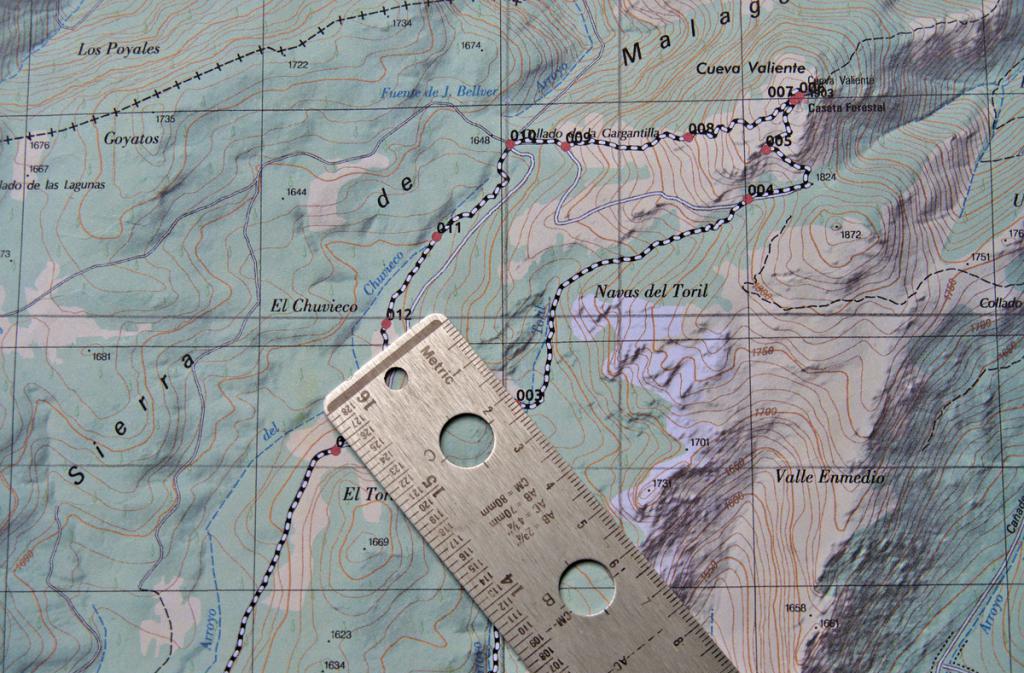
How to determine the longitude and latitude of a point more accurately than 0.5°? First you need to find out what scale the map you are working with is on. Typically, a scale bar is indicated in one of the corners of the map, showing the correspondence of distances on the map to distances in geographic coordinates and in kilometers on the ground.
After you have found a scale ruler, you need to take a simple ruler with millimeter divisions and measure the distance on the scale ruler. Let, in the example under consideration, 50 mm correspond to 1° latitude and 40 mm correspond to 1° longitude.
Now we position the ruler so that it is parallel to the lines of longitude drawn on the map, and measure the distance from the point in question to one of the nearest parallels, for example, the distance to the 11° parallel is 35 mm. We make a simple proportion and find that this distance corresponds to 0.3° from the 10° parallel. Thus, the latitude of the point in question is +10.3° (the plus sign means north latitude).
Similar steps should be done for longitude. To do this, place the ruler parallel to the lines of latitude and measure the distance to the nearest meridian from the selected point on the map, let’s say this distance is 10 mm to the meridian 67° west longitude. According to the rules of proportion, we find that the longitude of the object in question is -67.25° (the minus sign means western longitude).
Converting the received degrees into minutes and seconds

As stated above, 1° = 60" = 3600". Using this information and the rule of proportion, we find that 10.3° corresponds to 10°18"0". For the longitude value we get: 67.25° = 67°15"0". In this case, the proportion was used for conversion once for longitude and latitude. However, in the general case, when after using the proportion once fractional values of minutes are obtained, it should be use the proportion a second time to get the value of incremental seconds. Note that the accuracy of determining coordinates up to 1" corresponds to an accuracy on the surface of the globe equal to 30 meters.
Recording received coordinates
After the question of how to determine the longitude of an object and its latitude has been answered, and the coordinates of the selected point have been determined, they should be written down correctly. The standard form of notation is to indicate longitude after latitude. Both values must be specified with as many decimal places as possible, since this determines the accuracy of the object's location.
Defined coordinates can be represented in two different formats:
- Using only the degree icon, for example +10.3°, -67.25°.
- Using minutes and seconds, for example 10°18"0""N, 67°15"0""W.

It should be noted that in the case of representing geographic coordinates only using degrees, the words “north (south) latitude” and “east (west) longitude” are replaced by the corresponding plus or minus sign.