The Barents Sea is located in the westernmost part of the Eurasian shelf. The area of the Barents Sea is 1,300,000 km2. According to the International Hydrographic Bureau, the Barents Sea is separated from the Arctic basin by the Spitsbergen archipelago, the Bely and Victoria islands and the Franz Josef Land archipelago.
In the east, its border with the Kara Sea runs from Graham Bell Island to Cape Zhelaniya and along the Matochkin Shar straits (island New Earth), Kara Gate (between the islands of Novaya Zemlya and Vaygach) and Yugorsky Shar (between the islands of Vaygach and the mainland).
In the south, the Barents Sea is limited by the coast of Norway, the Kola Peninsula and the Kanin Peninsula. To the east is the Czech Bay. To the west of the Kanin Peninsula is the Gorlo Strait of the White Sea.
In the southeast, the Barents Sea is limited by the Pechora Lowland and the northern end of the Pai-Khoi ridge (a branch of the Ural ridge in the north). In the west, the Barents Sea opens wide into the Norwegian Sea and therefore into the Atlantic Ocean.
Temperature and salinity of the Barents Sea
The location of the Barents Sea between the Atlantic Ocean and the Arctic Basin determines its hydrological features. From the west, between Bear Island and Cape North Cape, there is a branch of the Gulf Stream - the North Cape Current. Heading east, it gives off a series of branches following the bottom topography.Temperature Atlantic waters 4-12° C, salinity approximately 35 ppm. When moving north and east, Atlantic waters cool and mix with local waters. The salinity of the surface layer drops to 32-33 ppm, and the temperature at the bottom to -1.9 ° C. Small flows of Atlantic waters through deep straits between the islands enter the Barents Sea from the Arctic basin at a depth of 150-200 m. Cold surface waters from the Arctic The basin is brought by polar waters. The waters of the Barents Sea are carried out by a cold current running south from Bear Island.
Ice conditions in the Barents Sea
Good isolation from the ice masses of the Arctic Basin and the Kara Sea is of particular importance for the hydrological conditions of the Barents Sea. Its southern part does not freeze, with the exception of individual fiords of the Murmansk coast. The edge of the floating ice runs 400-500 km from the coast. In winter, it adjoins the southern coast of the Barents Sea east of the Kola Peninsula.In summer floating ice usually melt and only in the coldest years persist in the middle and northern parts of the sea and near Novaya Zemlya.
Chemical composition of the waters of the Barents Sea
The waters of the Barents Sea are well aerated as a result of intense vertical mixing caused by temperature changes. In summer, surface waters are supersaturated with oxygen due to the abundance of phytoplankton. Even in winter, in the most stagnant areas near the bottom, oxygen saturation is observed at least 70-78%.Due to the low temperature, the deep layers are enriched with carbon dioxide. In the Barents Sea, at the junction of cold Arctic and warm Atlantic waters, there is the so-called “polar front”. It is characterized by the rise of deep waters with increased content nutrients(phosphorus, nitrogen, etc.), which determines the abundance of phytoplankton and organic life in general.
Tides in the Barents Sea
Maximum tides were recorded at the North Cape (up to 4 m), in the Throat of the White Sea (up to 7 m) and in the fiords of the Murmansk coast; further to the north and east, the tidal magnitude decreases to 1.5 m near Spitsbergen and to 0.8 m near Novaya Zemlya.Climate of the Barents Sea
The climate of the Barents Sea is very variable. The Barents Sea is one of the stormiest seas in the world. Warm cyclones pass through it from North Atlantic and cold anticyclones from the Arctic, which causes slightly higher air temperatures compared to other Arctic seas, moderate winters and heavy precipitation. Active wind regime and extensive area open waters create conditions near the southern coast for maximum storm waves up to 3.5-3.7 m high.Bottom topography and geological structure
The Barents Sea has a slight slope from east to west. The depth is mostly 100-350 m and only near the border with the Norwegian Sea it increases to 600 m. The bottom topography is complex. Many gentle underwater elevations and depressions cause a complex distribution of water masses and bottom sediments. As in other sea basins, the bottom topography of the Barents Sea is determined by geological structure, associated with the structure of the adjacent land. The Kola Peninsula (Murmansk coast) is part of the Precambrian Fenno-Scandinavian crystalline shield, consisting of metamorphic rocks, mainly Archean granite-gneisses. Along the northeastern edge of the shield stretches a Proterozoic folded zone composed of dolomites, sandstones, shales and tillites. The remains of this folded zone are located on the Varanger and Rybachy peninsulas, Kildin Island and in a number of underwater hills (banks) located along the coast. Proterozoic folds are also known to the east - on the Kanin Peninsula and the Timan Ridge. Underwater rises in the southern part of the Barents Sea, Pai-Khoi Ridge, northern tip Ural mountains and the southern part of the Novaya Zemlya fold system extend in the same northwestern direction. The vast Pechora depression between the Timan Ridge and Pai-Khoi is covered with a thick layer of sediments up to Quaternary; to the north it passes into the flat bottom of the southeastern part of the Barents Sea (Pechora Sea).The flat island of Kolguev, located northeast of the Kanin Peninsula, consists of horizontally occurring Quaternary sediments. in the west, in the region of Cape Mordkap, Proterozoic sediments are cut off by the Caledonian structures of Norway. They extend northeast along western edge Fenno-Scandinavian shield. The Caledonides of the same submeridional strike form western part Spitsbergen. The Medvezhinsko-Spitsbergen shallow waters, the Central Upland, as well as the Novaya Zemlya fold system and adjacent banks can be traced in the same direction.
Novaya Zemlya is composed of folds of Paleozoic rocks: phyllites, shales, limestones, sandstones. Manifestations of Caledonian movements were found along west bank, and it can be assumed that here the Caledonian structures are partially buried by young sediments and hidden under the seabed. The Vaigach-Novaya Zemlya fold system of Hercynian age is S-shaped and probably bends around massifs of ancient rocks or crystalline basement. The Central Basin, the Northeast Basin, the Franz Victoria Trench to the west of Franz Josef Land and the St. Anna Trench (the Gulf of the Arctic Basin) to the east of it have the same submeridional strike with an S-shaped bend. The same direction is inherent in the deep straits of Franz Josef Land and the underwater valleys located in their extension to the north into the Arctic basin and south to the north of the Barents Sea plateau.
The islands in the northern part of the Barents Sea are platform in nature and are composed predominantly of sedimentary rocks that lie slightly inclined or almost horizontally. On Bear Island it is the Upper Paleozoic and Triassic, on Franz Josef Land it is Jurassic and Cretaceous, in the eastern part Western Spitsbergen- Mesozoic and Tertiary. The rocks are clastic, sometimes weakly carbonate; in the late Mesozoic they were intruded by basalts.
Barents Sea - washes the northern coast of the Scandinavian and Kola Peninsulas, Norway and Russia. Is marginal sea Arctic Ocean.
It is bounded from the north by the archipelagos and Franz Josef Land, from the east by the Novaya Zemlya archipelago.
The area of the Barents Sea is 1424 thousand sq. km. Volume - 282 thousand cubic meters. km. Depth: average - 220 m. maximum - 600 m. Borders: in the west with the Norwegian Sea, in the south with the White Sea, in the east with.
 Silver Baren...

 Oil from the bottom...
 Diving in Bar...
Northern Seas have long attracted Russian people with their riches. An abundance of fish, sea animals and birds, despite ice water, long and cold winter, made this region quite suitable for a well-fed life. And when a person is full, he doesn’t mind the cold.
In ancient times, the Barents Sea was called the Arctic, then Siversky or Northern, sometimes it was called Pechora, Russian, Moscow, but more often Murmansk, according to old name Pomeranian (Murmansk) region of the earth. It is believed that the first Russian boats sailed in the waters of the Barents Sea back in the 11th century. Around the same time, Viking boats began to sail here. And then trading settlements began to appear in the north of Rus', and fishing began to develop.
Until Russia acquired a full-fledged fleet capable of crossing the expanses of the northern seas, the northernmost Russian city was Arkhangelsk. Founded by decree of Tsar Ivan the Terrible in 1583-1584 near the Archangel Michael Monastery, the small city became the main Russian port where foreigners began to enter. sea vessels. An English colony even settled there.


This city, located at the mouth of the Northern Dvina flowing into the river, was very attractive to Peter I, and over time it became the Northern Gate of Rus'. It was Arkhangelsk that had the honor of playing a leading role in the creation of the Russian merchant and navy. Peter founded the Admiralty in the city in 1693, and founded a shipyard on the island of Solombala.

Already in 1694, the ship "St. Paul" launched from this shipyard - the first merchant ship of the Russian Northern Fleet. "St. Paul" had 24 guns on board, which Peter personally cast at the factory in Olonets. To equip the first ship, Peter himself turned the rigging blocks. The launching of "St. Paul" was carried out under the direct supervision of Peter. “St. Paul” was issued a “travel certificate” for the right to trade abroad. The ship "St. Paul" was the first of six three-decker merchant ships launched from the sovereign shipyard from 1694 to 1701. Since then, Arkhangelsk has become the center of all foreign trade activities Russian state. It was from here that the Russian North began to develop.

Of course, even before Peter’s time there were sailing directions for the mouth of the Northern Dvina, White Sea and the coastal part of the Siverskoye Sea, which were inherited by local pilots. But under Peter, these maps were refined and allowed fairly large ships to sail without the fear of running aground or a reef, of which there are a great many in these waters.
These places were very attractive for navigation due to their peculiarity, because the sea did not freeze here, thanks to the Gulf Stream, the warm waters of which reached these northern shores. This made it possible for ships to pass west into the waters of the Atlantic and further south to the shores of America, Africa, and India. But the absence sea ships, and short navigation times prevented the development of the waters of the North Sea. Only rare ships of brave sailors reached the shores of Spitsbergen and Franz Josef Land, which separated the North Sea from the vast expanses of the Arctic Ocean.
The study of the Barents Sea began in XVI-XVII centuries, in the era of the Great geographical discoveries. Seeking trade routes, European sailors tried to go east to go around Asia to get to China, but they could not go far due to the fact that most of them were covered with hummocks of ice that did not melt even during the short northern summer. The Dutch navigator Willem Barents, in search of northern trade routes, very carefully explored the waters of the North Sea.

He discovered the Orange Islands, Bear Island, and explored Spitsbergen. And in 1597, his ship was frozen in the ice for a long time. Barents and his crew left the ship frozen in the ice and began to make their way to the shore in two boats. And although the expedition reached the shores, Willem Barents himself died. Since 1853, this harsh North Sea began to be called the Barents Sea in his honor, although before that it was officially listed on maps as Murmansk.
Scientific exploration of the Barents Sea began much later. 1821-1824 Several sea expeditions were undertaken to study the Barents Sea. They were headed by the future president of the St. Petersburg Academy of Sciences, an honorary member of many Russian and foreign scientific institutions, tireless navigator, Admiral Fyodor Petrovich Litke. On the sixteen-gun brig "Novaya Zemlya" he went to the shores of Novaya Zemlya 4 times, explored and described it in detail.
.jpg)
He explored the depths of the fairway and the dangerous shallows of the White and Barents Seas, as well as geographical definitions islands. His book “Four Voyages to the Arctic Ocean on the Military Brig “Novaya Zemlya” in 1821-1824,” published in 1828, brought him worldwide scientific fame and recognition. A complete thorough study and hydrological characteristics of the Barents Sea were compiled during scientific expedition in 1898-1901 headed by the Russian scientist hydrologist Nikolai Mikhailovich Knipovich.
The efforts of these expeditions were not in vain; as a result, the rapid development of navigation in the northern seas began. In 1910-1915 A hydrographic expedition of the Arctic Ocean was organized. The goal of the expedition was to develop the Northern Sea Route, which would allow Russian ships to pass along the shortest route north coast Asia in Pacific Ocean to the eastern shores Russian Empire. The expedition, consisting of two icebreaking steamships - "Vaigach" and "Taimyr" under the leadership of Boris Andreevich Vilkitsky, went through the entire northern route from Chukotka to the Barents Sea, with wintering near the Taimyr Peninsula.

This expedition collected data on sea currents and climate, ice conditions and magnetic phenomena these edges. A.V. Kolchak and F.A. Mathisen took an active part in developing the expedition plan. The ships were manned by combat naval officers and sailors. As a result of the expedition, a sea route was opened that connected the European part of Russia with the Far East.

At the beginning of the twentieth century, measures were taken to develop the first port beyond the Arctic Circle. Murmansk became such a port. A very good location was chosen for the future port on the right bank of the Kola Bay. In 1915, during the First World War, Murmansk was upset and received city status. Making this port city made it possible Russian fleet gain access to the Arctic Ocean through an ice-free bay. Russia was able to receive military supplies from its allies, despite the blockade of the Baltic and Black Seas.

During Soviet times, Murmansk became the main base of the Northern Navy, which played a huge role in the victory of the USSR over Nazi Germany and the Great Patriotic War 1941-1945 The ships and submarines of the Northern Fleet became the only force that managed, under the most difficult conditions, to ensure the passage of convoys delivering military cargo and food for the Soviet Union from the allies.
During the war, Severomorsk destroyed more than 200 warships and auxiliary vessels, more than 400 transports and 1,300 aircraft fascist Germany. They provided escort for 76 allied convoys, which included 1,463 transports and 1,152 escort ships.

And now Northern Fleet The Russian Navy is based at bases located in the bays of the Barents Sea. The main one is Severomorsk, located 25 km from Murmansk. Severomorsk arose on the site of the tiny village of Vaenga, which in 1917 was inhabited by only 13 people. Now Severomorsk, with a population of about 50 thousand people, is the main stronghold of the northern borders of Russia.

The Northern Fleet serves with the most best ships Russian Navy. Such as the aircraft-carrying anti-submarine cruiser Admiral Kuznetsov
.jpg)
Atomic submarines capable of floating directly to the North Pole


The Barents Sea also served to develop the military potential of the USSR. An atomic test site was created on Novaya Zemlya and in 1961 a super-powerful 50-megaton test was carried out there. hydrogen bomb. Of course, the entire Novaya Zemlya and the adjacent territory suffered greatly and for many years, but Soviet Union for many years received priority in atomic weapons, which continues to this day.

For a long time, the entire water area of the Arctic Ocean was controlled by the Soviet Navy. But after the collapse of the Union, most of the bases were abandoned. Everyone and everyone is flocking to the Arctic. And after opening largest deposits oil on the Arctic shelf, the question arose of protecting the Russian northern possessions possessing strategic raw materials. Therefore, since 2014, Russia has been renewing its military presence in the Arctic. For this purpose, bases are now being unfrozen on Novaya Zemlya, on Kotelny Island, which is part of the New Siberian Islands, on the land of Franz Joseph and. Modern military camps are being built and airfields are being restored.


Since time immemorial, a lot of all kinds of fish have been caught in the Barents Sea. It was almost the main food of the Pomors. And carts with fish were constantly going to the mainland. There are still a lot of them in these northern waters, about 114 species. But the main types of commercial fish are cod, flounder, sea bass, herring and haddock. The population of the rest is falling.
.jpg)
This is the result of neglect of fish stocks. Lately, more fish have been caught than can be reproduced. Moreover, artificial breeding of Far Eastern crabs in the Barents Sea had a negative impact on the restoration of fish mass. The crabs began to multiply so quickly that there was a threat of disruption to the natural biosystem of this region.

But nevertheless, in the waters of the Barents Sea you can still find a variety of fish and marine animals such as seals, seals, whales, dolphins, and sometimes.
.jpg)
.jpg)
In pursuit of new oil and gas fields, oil-producing countries increasingly began to move north. Thus, the Barents Sea became the site of a conflict between Russia and Norway. And although in 2010 Norway and Russia entered into an agreement on dividing borders in the Barents Sea, disputes still do not subside. This year, the Russian Gazprom began industrial oil production on the Arctic shelf. About 300 thousand tons of oil will be produced within a year. By 2020, it is planned to reach a production level of 6 million tons of oil per year.

The return of the Russian Armed Forces to the Arctic could help settle these disputes. The Russian Arctic is the property of our people and it must be fully used for the benefit of the people and well protected from those who like to profit at the expense of others.

Despite the fact that the Barents Sea is the polar region, in last years this region is becoming increasingly popular for tourists, especially those interested in diving, fishing and hunting. This one is very interesting extreme view recreation like ice diving. The beauty of the under-ice world can surprise even experienced swimmers. For example, the span of the claws of Kamchatka crabs that breed in these waters sometimes exceeds 2 meters. But you need to keep in mind that diving under ice is an activity for experienced scuba divers.

And hunting on the islands of the Barents Sea for seals, seals or birds, which are apparently not visible here, will not leave any seasoned hunter indifferent.
.jpg)
Any diver, fisherman, hunter or just a tourist who has visited the Barents Sea at least once will still strive to get here to see these northern beauties that are impossible to forget.
Video: Barents Sea:...
The Barents Sea is located on the continental shelf. The southwestern part of the sea does not freeze in winter due to the influence of the North Atlantic Current. The southeastern part of the sea is called the Pechora Sea. The Barents Sea is of great importance for transport and fisheries - there are major ports- Murmansk and Vardø (Norway). Before World War II, Finland also had access to the Barents Sea: Petsamo was its only ice-free port. Serious problem is Nuclear pollution seas due to the activities of the Soviet/Russian nuclear fleet and Norwegian reprocessing plants radioactive waste. Recently, the sea shelf of the Barents Sea towards Spitsbergen has become the object of territorial disputes between the Russian Federation and Norway (as well as other states).
The Barents Sea is rich various types fish, plant and animal plankton and benthos. Common along the southern coast seaweed. Of the 114 species of fish living in the Barents Sea, 20 species are the most commercially important: cod, haddock, herring, sea bass, catfish, flounder, halibut, etc. Mammals include: polar bear, seal, harp seal, beluga whale, etc. Seal fishing is underway. Bird colonies abound on the coasts (guillemots, guillemots, kittiwake gulls). In the 20th century, the Kamchatka crab was introduced, which was able to adapt to new conditions and begin to reproduce intensively.
Since ancient times, Finno-Ugric tribes - the Sami (Lapps) - have lived along the shores of the Berents Sea. The first visits of non-autochonous Europeans (Vikings, then Novgorodians) probably began at the end of the 11th century, and then intensified. The Barents Sea was named in 1853 in honor of the Dutch navigator Willem Barents. The scientific study of the sea began with the expedition of F. P. Litke of 1821-1824, and the first complete and reliable hydrological characteristics of the sea were compiled by N. M. Knipovich at the beginning of the 20th century.
The Barents Sea is a marginal water area of the Arctic Ocean on the border with the Atlantic Ocean, between the northern coast of Europe in the south and the islands of Vaygach, Novaya Zemlya, Franz Josef Land in the east, Spitsbergen and Bear Island in the west.
In the west it borders with the Norwegian Sea basin, in the south with the White Sea, in the east with the Kara Sea, and in the north with the Arctic Ocean. The area of the Barents Sea located east of Kolguev Island is called the Pechora Sea.
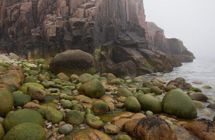
The shores of the Barents Sea are predominantly fjord, high, rocky, and heavily indented. Most large bays: Porsanger Fjord, Varangian Bay (also known as Varanger Fjord), Motovsky Bay, Kola Bay, etc. East of the Kanin Nos Peninsula, the coastal topography changes dramatically - the shores are mostly low and slightly indented. There are 3 large shallow bays: (Czechskaya Bay, Pechora Bay, Khaypudyrskaya Bay), as well as several small bays.
The largest rivers flowing into the Barents Sea are Pechora and Indiga.
Surface sea currents form a counterclockwise circulation. Along the southern and eastern periphery, the Atlantic waters of the warm North Cape Current (a branch of the Gulf Stream system) move east and north, the influence of which can be traced to the northern shores of Novaya Zemlya. The northern and western parts of the cycle are formed by local and Arctic waters coming from the Kara Sea and the Arctic Ocean. In the central part of the sea there is a system of intracircular currents. The circulation of sea waters changes under the influence of changes in winds and water exchange with adjacent seas. Tidal currents are of great importance, especially near the coast. The tides are semidiurnal, their greatest value 6.1 m off the coast of the Kola Peninsula, in other places 0.6-4.7 m.
Water exchange with neighboring seas is of great importance in the water balance of the Barents Sea. During the year, about 76,000 km³ of water enters the sea through the straits (and the same amount leaves it), which is approximately 1/4 of the total volume of sea water. The largest amount of water (59,000 km³ per year) is carried by the warm North Cape Current, which has an extremely large influence on the hydrometeorological regime of the sea. The total river flow into the sea averages 200 km³ per year.
The salinity of the surface layer of water in the open sea throughout the year is 34.7-35.0 ppm in the southwest, 33.0-34.0 in the east, and 32.0-33.0 in the north. In the coastal strip of the sea in spring and summer, salinity drops to 30-32, and by the end of winter it increases to 34.0-34.5.
The Barents Sea occupies the Barents Sea plate of Proterozoic-Early Cambrian age; elevations of the bottom of the anteclise, depressions - syneclise. From smaller relief forms, the remains of ancient coastlines, at a depth of about 200 and 70 m, glacial-denudation and glacial-accumulative forms and sand ridges formed by strong tidal currents.
The Barents Sea is located within the continental shallows, but, unlike other similar seas, most of it has a depth of 300-400 m, the average depth is 229 m and the maximum is 600 m. There are plains (Central Plateau), hills (Central, Perseus (minimum depth 63 m)], depressions (Central, maximum depth 386 m) and trenches (Western (maximum depth 600 m) Franz Victoria (430 m) and others). South part The bottom has a depth of mostly less than 200 m and is characterized by a leveled relief.
From the cover bottom sediments in the southern part of the Barents Sea sand predominates, in some places pebbles and crushed stone. At the heights of the central and northern parts of the sea - silty sand, sandy silt, in depressions - silt. An admixture of coarse clastic material is noticeable everywhere, which is associated with ice rafting and widespread relict glacial deposits. The thickness of sediments in the northern and middle parts is less than 0.5 m, as a result of which ancient glacial deposits are practically on the surface. The slow rate of sedimentation (less than 30 mm per 1 thousand years) is explained by the insignificant supply of terrigenous material - due to the characteristics of the coastal topography, not a single large river flows into the Barents Sea (except for the Pechora, which leaves almost all of its alluvium within the Pechora Estuary), and The shores of the land are composed mainly of durable crystalline rocks.
The climate of the Barents Sea is influenced by warm Atlantic Ocean and the cold Arctic Ocean. Frequent intrusions of warm Atlantic cyclones and cold Arctic air determine great variability of weather conditions. In winter, southwestern winds prevail over the sea, and in spring and summer, northeastern winds. Storms are frequent. The average air temperature in February varies from −25 °C in the north to −4 °C in the southwest. The average temperature in August is 0 °C, 1 °C in the north, 10 °C in the southwest. Cloudy weather prevails over the sea throughout the year. Annual quantity precipitation from 250 mm in the north to 500 mm in the southwest.
Severe climatic conditions in the north and east of the Barents Sea determine its high ice cover. In all seasons of the year, only the southwestern part of the sea remains ice-free. The ice cover reaches its greatest extent in April, when about 75% of the sea surface is occupied by floating ice. In exclusively Not favorable years At the end of winter, floating ice comes directly to the shores of the Kola Peninsula. Smallest quantity ice cover occurs at the end of August. At this time, the ice boundary moves beyond 78° N. w. In the northwest and northeast of the sea, ice usually remains all year round, but in some favorable years the sea is completely free of ice.
The influx of warm Atlantic waters determines relatively high temperature and salinity in the southwestern part of the sea. Here in February - March the surface water temperature is 3 °C, 5 °C, in August it rises to 7 °C, 9 °C. North of 74° N. w. and in the southeastern part of the sea in winter the water temperature on the surface is below −1 °C, and in the summer in the north 4 °C, 0 °C, in the southeast 4 °C, 7 °C. In summer, in the coastal zone, the surface layer of warm water 5-8 meters thick can warm up to 11-12 °C.
The sea is rich in various species of fish, plant and animal plankton and benthos, therefore the Barents Sea is of great economic importance as an area of intensive fishing. In addition, the sea route connecting the European part of Russia (especially the European North) with the ports of Western (since the 16th century) and Eastern countries (since the 19th century), as well as Siberia (since the 15th century) is very important. The main and largest port is the ice-free port of Murmansk - the capital Murmansk region. Other ports in Russian Federation- Teriberka, Indiga, Naryan-Mar (Russia); Vardø, Vadsø and Kirkenes (Norway).
The Barents Sea is a region where not only the commercial fleet, but also the Russian Navy, including nuclear submarines, are deployed.
The Barents Sea is a sea located on the edge of the Arctic Ocean. More precisely, it is located beyond the Arctic Circle, between Franz Josef Land, Vaygach and the Coast of Europe. The waters of the Barents Sea wash the shores of Norway, but most of all - Russia. This place has not been fully explored. Many people don’t even know what the salinity of the Barents Sea is and what the temperature of its waters is. Well, we can figure this out.
Fresh water effluent
The salinity and temperature of the Barents Sea depend on many indicators. After all, water comes here not only from rivers, but also from the Atlantic. All this affects salinity and temperature. It is worth clarifying that if we take into account the volume and area of the sea, in this case it is small. During the year, approximately 163 cubic kilometers of fresh water enter here. Most rivers flow into southeastern part Barents Sea. The largest arteries are marked here. Judging by the usual indicators of water content, Pechora discharges about 130 cubic meters water. This accounts for about 70% of the total river flow during the year. In this area, several other smaller bodies of water flow into the sea.
It is worth noting that only 10% of the river flow falls on the banks and coasts of Norway. After all, mostly small mountain streams flow here. The highest continental runoff is observed in spring, and the lowest in winter and autumn. But this also affects the salinity of the Barents Sea. River flow significantly affects only the hydrological conditions of the southeastern part. This area of the sea is the shallowest, and is often called the Pechersk basin.

Neighboring seas
The salinity of the Barents Sea, as well as the temperature of its waters, depend not only on fresh water runoff. Other factors also influence these indicators. Do not forget about water exchange with the neighboring seas. Of course, their features should also be taken into account. Most of the arrivals come from the Atlantic warm waters. The annual influx is approximately 74 thousand square kilometers.
Waters from neighboring seas bring from 177 to 1012 kcal of heat to the Barents Sea. Of this amount, only 12% is absorbed. The rest of the heat is spent in the Barents Sea. Naturally, the waters become not so cold. It is worth noting: the Barents Sea is the warmest sea among those that are part of the Arctic Ocean. Some areas here simply don't freeze. Water temperatures ranging from European shores to 75° northern latitude- constantly above zero.

Water structure
To determine the salinity of the Barents Sea, it is worth carefully examining the structure of its waters. At the moment, there are 4 main masses:
Barents Sea: water salinity
The Barents Sea is well connected to the ocean. At the same time, the continental flow of fresh water is small. Thanks to this, salinity indicators here practically do not change and do not differ from medium salinity ocean. It is worth noting that changes depend not only on seasons, but also on areas. For example, in the southwestern part the highest salinity of the Barents Sea is noted. Here this figure is 35 ‰. This is the North Cape Trench area. Salty Atlantic water masses pass through here and there is never ice.
In the southern and northern parts there is a decrease in indicators to 34.5 ‰. Ice melting is observed in this area. In the southeast, the water masses are even fresher. In this area, the salinity of the Barents Sea in ppm is approximately 32-33 ‰. The largest river flow of fresh water is noted here. Ice melting is also occurring in this area.

Salinity and layers
Changes in salinity indicators specifically in the water column depend on the influxes of Atlantic water masses, river runoff, as well as on the bottom topography. On the surface they can range from 34 ‰ and above, and at the very bottom - up to 35.2 ‰. To a lesser extent, vertical changes are observed over underwater elevations.
It is worth noting that salinity indicators practically do not change throughout the season. The changes are very weak. The surface layer in summer period more bland. A sharp increase in salinity with depth is observed from horizons of 25-30 meters. IN winter time such a jump is practically smoothed out. In the southeastern part, changes in salinity indicators are clearly visible with depth. It is worth noting that in such places the difference can be several ppm.
IN winter period There is a leveling off of indicators throughout almost the entire water column of the Barents Sea. In spring, the surface layer becomes fresher. In summer, this process only intensifies due to the melting of ice. That is why between horizons 10-25 there is a sharp jump in salinity indicators.

Density of waters
In addition, do not forget about other factors. For example, in the northern region of the sea, water masses are denser in winter, and in the central region - in summer. Moreover, the reasons similar phenomenon totally different. In the north this arises due to the arrival fresh water, and in the south - as a result of warming up.
Salinity of the Barents Sea by season
In winter, the indicator over the entire sea area is quite high and amounts to 35 ‰. The least is in the southeastern part - up to 33 ‰. This is due to the large influx Atlantic masses, a decrease in continental runoff and intensive ice formation. In spring, high salinity levels persist. The only exception is the narrow coastal strip in the Kaninsko-Kolguevsky district and off the Murmansk coast. Here the salinity decreases.
In summer, there is an influx of water masses from the Atlantic, the melting of ice and the spread river water. As a result of all this, the indicator decreases significantly. In the southeastern part, the mark may drop to 25 ‰, and in the southwestern part - to 34.5 ‰. In autumn, the indicators also remain low. However, due to the fact that continental runoff is gradually slowing down, the salinity of the Barents Sea is increasing in percentage. Moreover, during this period it begins intensive education ice. Gradually, the salinity indicator reaches the winter level.

In conclusion
Now you know what the salinity of the Barents Sea is and what affects it. Despite such fluctuations, about 110 species of fish live here. Their species diversity decreases from west to east. This is due to a decrease in water and air temperatures, as well as ice conditions. It is worth noting that the Barents Sea supplies many cities with cod, goby and flounder species. At the moment, haddock, capelin, herring, halibut, cod, catfish, cod and sea bass are caught here.
Located on the westernmost part of all arctic seas. The Barents Sea is located on the North European shelf. The northern and western boundaries of the sea have a conventional line. Western border passes along Cape Yuzhny, Medvezhy, Cape North Cape. Northern - along the outskirts of the islands of the archipelago, then along a number of other islands. From the southern part, the sea is limited by the mainland and a small strait delimiting the Barents Sea from. Eastern border passes through the Vaigach Islands and some others. The Barents Sea is a continental marginal sea.
The Barents Sea occupies one of the first places among its size. Its area is 1 million 424 thousand km2. The volume of water reaches 316 thousand km3. The average depth is 222 m, the greatest depth is 600 m. In the waters of the Barents Sea there are a large number of islands (Novaya Zemlya, Medvezhiy and others). Small islands are mainly grouped into archipelagos, which are located next to the mainland or large islands. The sea is quite uneven, complicated by various capes, bays and bays. The shores washed by the Barents Sea have different origins and structure. The Scandinavian coastline and mostly abruptly ends towards the sea. The western coast of the island of Novaya Zemlya has. And the northern part of the island is in contact with, some of which flow into the sea.
Fishing is widely developed in the Barents Sea. Cod, haddock, sea bass, and herring are obtained from the waters of this sea. There is a power plant near Murmansk that generates energy using. Also in Murmansk is the only ice-free port in our country, which is located in the polar zone. Thus, the Barents Sea is an important sea route connecting Russia with other countries.
The open part of the Barents Sea is not very polluted compared to other Arctic seas. But the area where ships actively move is covered with film. The waters of the bays (Kola, Teribersky, Motovsky) are subject to the greatest pollution, mainly from oil products. About 150 million m3 of polluted water enters the Barents Sea. Toxic substances constantly accumulate in the sea soil and can cause secondary pollution.