Baikal-Amur Mainline
(BAM) - railway route to Vost. Siberia and the D. East, 2nd main railway. CCCP output to Tech approx. It runs through the territory. north p-nov of the Irkutsk region. (pre-Baikal area), Buryat. ACCP, Chita region. (Trans-Baikal area), Amur region. and Khabarovsk Territory (Far Eastern section). The total length of the route from Taishet to Sov. The harbor is 4,300 km, of which the Ust-Kut (on the Lena) - Komsomolsk-on-Amur section, which has been under construction since 1974, is 3,100 km; it is adjacent to two previously built sections: Taishet - Ust-Kut (733 km, commissioned in 1958) and Komsomolsk-on-Amur - Sov. Harbor (434 km, commissioned in 1947). Three will connect. lines connect the BAM with the Trans-Siberian railway. d.: Bam - Tynda, Izvestkovaya - Urgal and Volochaevka - Komsomolsk-on-Amur. The territory included in the zone of influence of the BAM (approx. 1.5 million km 2) is distinguished by very difficult natural conditions, geological. structure and relief, development of permafrost, strong seismicity, that is. swampiness, which determines a large volume of geological research, geological engineering and hydrogeol. research related to the laying of the route, the construction of station and other villages and cities, and the development of mineral resources.
Relief. The Pre-Baikal area occupies the Prilenskoye (Angaro-Lenskoye) plateau with a predominance of soft relief forms - wide flat watersheds, small depressions and plains. Abs. altitudes range from 400-1000 m. Tpacca is laid in the main. along the valleys pp. Lena, Tayura, Kirenga, Kunerma. The Trans-Baikal section is entirely located within the Baikal Mountain. countries. B spare Parts of it are the Baikal, Akitkan, Synnyr and Barguzin ridges with altitudes of up to 2600 m. The Baikal ridge is characterized by alps. - trough valleys, cirques and rocky ones (), etc.; The ridges have features of alpine plateaus. East part is occupied by the vast and complexly constructed Stanovoe, where elongated W. - S. - W. on B. - C.-B. high ridges and deep basins. The latter divide this highland into two chains: the northern, which includes the Verkhneangarsky, Delyun-Uransky, North-Muysky, Muyakansky and Kodarsky ridges, the southern - the South-Muysky, Kalarsky and Udokansky ridges. Abs. altitudes reach 2800 m (Skalisty char in the Kalar range). All ridges represent systems of dome-shaped or flat-topped char, covered with placers of coarse sediments, in the axial parts of the ridges - the Alps. landforms; there are traces of the ancient, and in the Kodar ridge - and modern. glaciations (circuses, karras, moraines, glacial lakes). B.h. The route in this section intersects the largest basins - Verkhneangarskaya, Muysko-Kuandinskaya and Verkhnecharskaya, with an abs. heights 500-700 m and hilly-flat. The Trans-Baikal section includes all the BAM tunnels, the total length of which is 26 km, incl. Severo-Muysky 15.3 km, Baikalsky 6.7 km. The Far Eastern area combines medium- and low-altitude areas with extensive accumulative-denudation plains. Tpacca runs along the south here. spurs of the Stanovoy Range, crosses the Tukuringra-Dzhagdy, Turana, Bureinsky, Dycce-Alinsky, Badzhalsky, Sikhote-Alin ridges and reaches the coast. Approximately 1/3 of the Far Eastern section of the route runs along the Verkhnezeyskaya and Amur-Zeysko-Bureya plains, which have a steep and heavily swampy topography. B horn p-nah she passes first. along mountain slopes and river valleys (left tributaries of the Amur).
Geological structure. The territory adjacent to BAM covers several fragments. largest tectonic structures - the Siberian platform, the Baikal and Stanovoy forges. regions, Mongol-Okhotsk and Sikhote-Alin fold systems (see map).
These structures are limited by thick, extended fault zones; numerous ones determine their mosaic block structure. Duration and the complex history of geology. development predetermined the wide distribution of sedimentary, volcanogenic, intrusive, and metasomatic rocks of different ages (from Archean to Cenozoic). and metamorphic. complexes of extremely diverse composition, as well as the items associated with them. Zap. part (bass pp. Angara, Nizhnyaya Tunguska, upper Lena) belongs to the southeast. outskirts of the Siberian platform. Gentle-lying carbonate-terrigenous Paleozoic and Mesozoic rocks, saturated with diabase sills, are developed here. B West. The Baikal region of Paleozoic and underlying Proterozoic sediments increases sharply, as does the degree of their dislocation (Angaro-Lena trough). In the Baikal mountain. metamorphosed and dislocated sedimentary and volcanogenic strata are widespread in the country. Archean, Proterozoic and lower. Paleozoic, permeated with intrusions of various compositions. There are exits of the most ancient crystalline. foundation (Baikal, Severo-Muyskaya, etc.). Mesozoic sedimentary, volcanogenic and intrusive formations are observed in places. Large depressions of the Baikal type are filled with a thickness of loose Cenozoic sediments ( cm. Baikal). Metamorphic rocks are developed within the Aldan shield. lower thickness Archaea, among which numerous have been mapped. suture troughs (troughs) with greenstone sedimentary-volcanogenic-siliceous formations. In the Kodaro-Udokan region they are overlain by a thick layer of Lower Proterozoic terrigenous sediments, and in the pp. basins. Zhuya, Aldan, Uchur - gently lying terrigenous and carbonate deposits of the Proterozoic, Vendian, Paleozoic and Mesozoic. Along the south Along the outskirts of the shield there are depressions with Jurassic and Cretaceous coal-bearing deposits (Chulmanskaya, Tokyo, etc.). Intrusive formations include ancient granites, gabbro, Paleozoic, Mesozoic minor alkaline composition, Proterozoic intrusions of alkaline ultrabasic rocks. Standing forge the region is characterized by a wide distribution of Archean metamorphic. rocks and granite-gneisses, Mesozoic granitoids. There are troughs with Precambrian greenstone complexes. Disconnected Mesozoic volcanics are observed everywhere. buildings, small intrusions of various compositions, as well as grabens made of coal-bearing Jurassic and Cretaceous deposits. In the Mongol-Okhotsk fold system, metamorphosed and dislocated sedimentary and volcanogenic strata of the Proterozoic, Paleozoic and Mesozoic, intruded by intrusions of different ages, are developed. Mesozoic volcanics are known in the basin of the Zeya and its tributaries. buildings and depressions filled with coal-bearing deposits. Within the Bureya massif, ancient granitoids predominate, cutting through Precambrian crystalline rocks. . In the B. region, sedimentary-volcanogenic formations of the Mesozoic and Paleozoic are developed, composing the Sikhote-Alin fold system. Volcanic rocks are very numerous. buildings and belts (Primorsky, Yam-Alinsky), in the structure of which Mesozoic and Paleogene-Early Quaternary volcanics take part. breeds Late Mesozoic granitoids predominate among the intrusive formations. A series of large rift depressions and extensive troughs are formed by Cenozoic sediments (Tugursky, Khabarovskaya, etc.).
Seismicity. Part of the BAM zone is highly seismic. The pre-Baikal section, which runs along the Siberian platform, is practically aseismic, but sometimes “transit” seismic forces of up to 5 points come here from the Baikal seismic side. belts The most seismic area is the Transbaikal region. It has been established that earthquake epicenters are grouped into a relatively narrow strip along the chain of rift basins; At the same time, inter-rift forges are characterized by increased seismicity. lintels (Verkhneangarsko-Muyskaya, Muysko-Chara). Seismic The situation in the Far Eastern sector is very different. Elevated to B. from the Udokan ridge and in the p-not cp. current p. Olekma is connected with the system of ruptures of the Stanovoy fault. K B. from p. In Olekma, seismicity weakens, but in the region of the Tukuringra-Dzhagdy ridge it increases again; it is connected to the Mongol-Okhotsk fault. Further on in B. earthquakes occur less frequently and of lesser magnitude, however, there are seismic events here too. foci (Zeysky, Amgunsky, etc.) with earthquake strengths up to 7 points. Thus, BAM is located in complex engineering and seismological areas. conditions; When designing structures, anti-seismic protection is provided. strengthening of structures.
Permafrost. Last entry the site belongs to the unfrozen zone; in the rest of the territory it is distributed either in the form of islands or everywhere. K B. from the Angara to the Baikal ridge occupies small areas, found in the form of separate. massifs in swampy river valleys and in the north. slopes In large rift depressions of the Baikal mountain. region is developed only on floodplains and the first terraces of rivers, on deluvial plumes and alluvial cones, which are usually swampy. The thickness of permafrost rocks can apparently reach values from 150 to 500-600 m. Framed by depressions with ridge heights of 2000-2800 m, the most severe permafrost conditions exist. Permafrost strata are characterized by an almost continuous distribution, interrupted by taliks only in the bottoms of deeply incised large valleys and zones of flooded faults. Their thickness apparently reaches more than 1 km. In the Aldan shield, the continuity and thickness of permafrost increases with height. The mildest permafrost conditions exist in the altitude range of 800-1000 m, where watersheds are usually thawed. Such watersheds are developed by ch. arr. within Mesozoic coal-bearing depressions. Even the permafrost is once again receiving priority. continuous distribution, interrupted by taliks only in the valleys of large rivers. The watershed spaces of the highest ridges (Stanovoi, Yankan, Tukuringra), as a rule, are frozen, the thickness of the permafrost reaches 200 m. In the south. on slopes and on low (500-1000 m) watersheds, the thickness of permafrost is sharply reduced, and taliks are widely developed; swampy valley bottoms and deluvial plumes at the foot of the slopes are permafrost. B mid-mountain In the Amur ridges (Soktakhan, Dzhagdy, Aesop, Dycce-Alin, Bureinsky, etc.), the structural patterns of cryolithosis are similar. Permafrost conditions between mountains. depressions are more differentiated. In the northernmost of them, Verkhneseyskaya, permafrost settlements have an almost continuous distribution. Within the Zee-Bureya Plain, they line the bottoms of wide swampy valleys, measured ridges, and watersheds composed of finely dispersed sediments on the surface.
The groundwater. Depending on natural conditions, there are large differences in the conditions for the formation of resources and the composition of groundwater. In the platform conditions of the Angara-Lena Plateau, formation and formation-karst waters predominate in the terrigenous-carbonate rocks of the Ordovician and lower. Cambrian, to a lesser extent in alluvial and glacial deposits. Large centers of groundwater discharge sometimes form in areas of contact between highly permeable carbonate rocks and weakly permeable terrigenous rocks, forming lithological rocks. barriers. In the Baikal mountain. country means. Groundwater resources are concentrated in alluvial and lacustrine-alluvial deposits, in massifs of carbonate rocks in fault zones (talik waters). The Aldan Shield and the Stanovoy Range are also associated mainly with continuous taliks in alluvial deposits; There are fissure sub-permafrost and fissure-vein waters in fault zones. In the Zeya and Zee-Bureya depressions, abundant horizons of pressure water (often sub-permafrost) are associated with Jurassic and Cretaceous sandstones and lacustrine-alluvial deposits. In the Bureinsky ridge and the Sikhote-Alin region there are, therefore. accumulations of formation and fissure waters; for practical The most suitable for use are groundwater from alluvial deposits of river valleys.
Important for the formation of hydrogeols. conditions for b.h. The territories of the BAM zone have permafrost. In some cases, they exclude huge massifs from active water exchange, in others they serve as a regional aquitard, separating waters into sub-permafrost and supra-permafrost. zones are extremely diverse in chemical composition. composition, which is determined by the chemical composition of the water-bearing rocks. The degree of water mineralization also varies within very wide limits (from 0.1 to 630 g/l). Quite numerous mineral waters. The East Siberian hydromineral region of nitrogen and methane chloride and sulfate salt waters and brines, the Baikal region of nitrogen and methane thermal waters, the Nizhne-Amur region of cold carbon dioxide waters, the Amur-Primorsky region of nitrogen and methane thermal waters are distinguished. Mineral waters can be used here in medicinal, thermoenergetic, industrial. purposes, as a source of production of table salt, etc.
Engineering-geological conditions. The most common feature of engineering-geol. structure of the zone - the predominant development of rocks, covered insignificantly. a cover of loose Quaternary sediments of eluvial, deluvial, alluvial and glacial origin. The thickness of this cover is 2-3 m, in rare cases more than 10-15 m. This is an engineering geological object. development; it contains over-deepened valleys, includes certain fields of development of glacial and water-glacial deposits, and large deluvial plumes. A significantly smaller area is occupied by the districts where all engineering and geological research is carried out. composed of loose Cenozoic sediments. These are the rift depressions of the Baikal region and large depressions of the Amur region.
The most important factor in the formation of engineering-geological. conditions - modern geol. processes and phenomena. In the BAM zone, slope processes (deluvial washout, and especially stone rivers) are ubiquitous, which pose a particular danger during above-ground construction. Avalanches and associated forms (foci, chutes, plumes) are widespread on alpine ridges. The BAM zone is covered by ice dams of groundwater and groundwater, which have different dimensions and dynamics. Means. Some of the aufeis have developed well-defined aufeis glades. Cryogenic phenomena such as polygonal formations (re-veined ice, ground veins, etc.), structural soils (stone rings, medallion spots, etc.) associated with ch. arr. with valley bottoms, wide watersheds, plains. In general, the conditions for engineering development of the BAM zone are difficult, especially within the Baikal folded region, where high seismicity, the most severe permafrost and high mountains are combined. relief.
Mineral raw materials. The BAM zone is a relatively little studied, but promising region in the east of the country: known large deposits and ore occurrences allow us to count on the possibility of opening new industries. deposits of various items and. The Siberian platform is known for gas condensate deposits (Markovskoe, Yaraktinskoe, etc.), thick rock formations. and potassium salts (Nepsko-Gazhensky), small deposits and occurrences of phosphorites, coals, and cuprous sandstones were discovered. To the west from Ust-Kut, iron deposits have been identified and explored. ores of the Angaro-Ilimsky and Angaro-Katsky districts. In the Baikal mountain. In the country, pyrite-polymetallic deposits are of paramount importance. ores in greenstone strata of the Proterozoic (Kholodninskoye), muscovite (Mamsky district), chrysotile-asbestos (Molodezhnoe), gold (placers and small ore deposits) and various ornamental stones. Polymetallic fluorite is also known. deposits in carbonate strata (Barvinskoye, Tabornoe, etc.), occurrences of nickel, molybdenum, tungsten, rare elements, as well as stones. and brown coal. For the Aldan shield the most important are stones. coal and iron. In addition to gold ore deposits (Aldan region), numerous are known. placers. Coal deposits have been explored in the Chulman depression; The prospects for the Tonkin Basin and other Mesozoic depressions forming the South Yakutsk are significant. Deposits of cuprous sandstones are known in the western Aldan shield (Udokan deposit). In Chapo-Tokki p-not established means. iron reserves (magnetite quartzites in ancient strata), deposits of metasomatic iron ores have not been explored in the South Aldan region. type (Taiga, Desovskoe, Pionerskoe, etc.). Phlogopite deposits are being developed (Aldan region), deposits of apatite (Seligdarskoye), copper-cobalt ores with platinum group metals (Chineiskoye), rare elements, as well as corundum, graphite, charoite (the only deposit in the world) have been discovered. , horn crystal, etc.
In the Stanovoy region industrial gold mining matters; ore occurrences of molybdenum, cuprous sandstones, and polymetallic minerals have been identified. ores, mercury, rare elements, apatite, magnetite ores, ornamental stones, builds. materials. The Mongol-Okhotsk system and the Bureinsky system are characterized by numerous. placers and small deposits of ores of gold, iron (Garinskoye), coal (), manifestations of tin-polymetallic. ores, molybdenum, manganese, phosphorites. In the Sikhote-Alin system, the leading role belongs to the mining of tin (Komsomolsky, Badzhalsky and other regions); deposits of gold and tungsten ores are also known.
The Neogene-Quaternary depressions contain stones. and brown coal (Lianskoye deposit). In all areas of the BAM development zone there are numerous deposits of various types. builds. materials, the reserves of which ensure the construction of the route itself, industrial and residential facilities.
The development of mineral resources along with logging will give impetus to the development of the production forces of the BAM zone. Large reserves of valuable items. contribute to the formation of territorial production based on them. complexes, such as in South. Yakutia, where large-scale coal mining is developing, and iron mining is possible in the future. ores, apatite, etc. Literature: Pinneker E. V., Pisarsky B. I., Underground waters of the Baikal-Amur Mainline zone, Novosibirsk, 1977; Nekrasov I. A., Klimovsky I. V., Permafrost of the BAM zone, Novosibirsk, 1978; Sobolev Yu. A., Zone of the Baikal-Amur Mainline; ways of economic development, M., 1979; Krasny L.I., Geology of the Baikal-Amur Mainline region, M., 1980; Kuznetsov V. A., Problems of metallogeny of the BAM zone, "", 1980, No. 6. L. I. Krasny (geological structure), M. S. Naumov (seismicity, permafrost, groundwater, engineering-geological conditions), A. F. Pryalukhina (relief, geological structure, mineral resources).
Mountain encyclopedia. - M.: Soviet Encyclopedia. Edited by E. A. Kozlovsky. 1984-1991 .

Text for the lecture “Along the Baikal-Amur Mainline”
Slide 2-3
The Baikal-Amur Mainline (BAM) is a railway in Eastern Siberia and the Far East. One of the largest railway lines in the world. The length of the main route Taishet - Sovetskaya Gavan is 4287 km. The BAM runs north of the Trans-Siberian Railway, branching off from it in Taishet, crosses the Angara in Bratsk, crosses the Lena in Ust-Kut, passes through Severobaikalsk, skirting Lake Baikal from the north, then passes through Tynda, crosses the Amur in Komsomolsk-on-Amur and ends on the shore of the Pacific Ocean in Sovetskaya Gavan. Branches: to Ust-Ilimsk (215 km); to the Chineyskoye field (66 km); to Bamovskaya station (179 km); to Yakutsk (at the end of 2010, 930 km had been built, construction continues on the Kardem - Yakutsk section) (1078 km); to the Elginskoye field (300 km); to Izvestkovaya station (326 km); to Chegdomyn (16 km); to Volochaevka station (351 km); to the Black Cape station - the road to the abandoned construction site of an underwater tunnel to Sakhalin Island (120 km).
Slide 4
The highway route passes mainly in mountainous areas, including through the Stanovoye Highlands, cutting through seven mountain ranges. The highest point of the path is Mururinsky Pass (1323 meters above sea level); Steep slopes when approaching this pass require the use of double traction and limiting the weight of trains. There are ten tunnels along the road route, among them is the longest tunnel in Russia, the Severo-Muysky Tunnel.
The road route crosses 11 major rivers; a total of 2,230 large and small bridges were built on it. The highway passes through more than 200 railway stations and sidings, more than 60 cities and towns.
From Taishet to Ust-Kut the road is double-track and electrified with alternating current (25 kV), from Ust-Kut to Taksimo station the road is single-track and electrified with alternating current (25 kV), to the east the movement is carried out on diesel traction.
Characteristics of BAM:
Operating length - 3509 km.
The length of the straight lines is 1899.8 km.
The length of the curves is 1617.5 km.
The number of ISSO is 3802 km.
incl. pipes - 1525 pcs.
small bridges - 1162 pcs.
medium bridges - 940 pcs.
large bridges - 195 pcs. incl.
h\r Lena - 419 m.
h\r Upper Angara - 513 m.
h\r Vitim - 556.8 m.
h\r Selemzha - 706.4 m.
b\r Bureya - 957 m.
total bridges - 1297
The total length of the bridges is 96.1 km.
There are 9 tunnels in total, incl.
Baikal:
Severomuysky - 15,337 m.
Kodarsky - 2040 m.
Nagorny - 1240 m.
Dusse - Alinsky - 1807 m. (restored)
The total length of the tunnels is 32.3 m.
Stations - 66
Passages - 144
P. posts - 7
Overpasses - 11
Operating length of the Baikal-Amur Railway from Taishet to Sovetskaya Gavan, taking into account the adjacent sections Izvestkovaya - New Urgal - Chegdomyn, Dzemgi - Komsomolsk-Sort. – Volochaevka-2, Tynda – Sturm, the Bestuzhevo – Neryungri section is 5676 km, including:
The length of double-track sections is 849 km (15%) (as of 01/01/2006);
The length of single-track sections is 4827 km (85%);
1,751 km (31%) were electrified;
The length of sections using diesel locomotive traction is 3925 km (69%);
Equipped with automatic locking 4189 km (74%);
Equipped with dispatch centralization 4134 km (73%);
Equipped with semi-automatic blocking 1478 km (26%).
The useful length of the receiving and dispatching tracks on the highway from Taishet to Komsomolsk corresponds to the standard 71 standard. (1050 m). On the Komsomolsk - Sovetskaya Gavan section, the length of the receiving and departure tracks does not exceed 850 m (less than 71 level).
The main limiting element of the infrastructure on the route of cargo to the ports of Vanino and Sovetskaya Gavan is the railway crossing of the Sikhote-Alin ridge in the Kuznetsovsky pass area (Kosgrambo - Vysokogornaya section - 31.1 km). Currently, due to this section of the railway (with a rise of 27‰) in the Komsomolsk-Sort direction. – Trains operate currents with a weight limit limited to 3600 tons. On the rest of the Baikal-Amur Mainline, in the direction Taishet - Komsomolsk, it is possible to implement weight standards of 5600-5800 tons.
In general, the direction from Taishet to Sovetskaya Gavan is characterized by a rather complex profile: slopes of 19-24‰, curves of small radius, in some sections small bridges are located every 100-200 m. The average length of the hauls is 25-30 km.
Due to the unsatisfactory condition of the track (deformation of the roadbed, small radius curves) on 30% of the length of the main line (about 1500 km), the maximum speed of freight trains does not exceed 45 km/h, while the section speed is 38 km/h, which has a significant impact to limit the available capacity of the route as a whole.
In addition, over the past decades there has been a significant aging of the main signaling devices (3000 km), communications (2500 km).
Currently, the highway ensures the transportation of cargo to the ports of Vanino and Sovetskaya Gavan in the amount of 8-10 million tons/year, while for 280 km of the route already in 2006 there were no reserves of capacity.
Slide 5. Brief information about the natural conditions in the BAM zone
The natural conditions of the Baikal-Amur Railway are complex and have great diversity. They are characterized by mountainous terrain in the western area and haze areas in the eastern part.
All areas of the highway are characterized by almost arctic climate severity, which determines the presence of permafrost, the widespread development of active physical and geological phenomena and processes, high seismicity, snow avalanches (especially in the western section of the highway), mudflows, etc., which are the reason for the large volume of work and the complexity of construction.
The highway route passes through a complexly dissected mountain taiga region.
Over 3,500 watercourses are crossed along the route. Among them are the largest rivers of Siberia and the Far East: Lena, Kirenga, Upper Angara, Vitim, Olekma, Nyukzha, Zeya, Selemdzha, Bureya, Amgun.
The rivers are mountainous in nature and fast flowing.
Floods are characterized by a short duration with sharp 6–10-meter rises and falls in levels, and high flow speeds.
The climate of the entire BAM zone is sharply continental with long cold winters (8 months) and short warm and rainy summers.
Average annual air temperatures throughout the BAM zone are negative and vary from minus 3.2 (Nizhneangarsk) to minus 7.8 °C (Chara). The absolute minimum temperatures reach minus 60 °C, the absolute maximum air temperature reaches plus 40 °C.
The route passes in the southern zone of the permafrost development area. This determines the combination in a number of sections of the route of permafrost and thawed rocks, high-temperature (0 – minus 1.5 ° C) and low-temperature (minus 1.5–6.6 ° C) permafrost soils, large differences in the thickness of frozen strata (from 0.5 up to 100–200 m or more).
The annual precipitation throughout the BAM zone ranges from 350 to 700 mm or more.
The calculated intensity during the design was taken to be no higher than 9 points, with catastrophic earthquakes of 10–12 points recorded.
The highway route for 410 km runs in the zone of magnitude 8 earthquakes and 740 km in the zone of magnitude 9 earthquakes.
Slide 6. Brief information about the natural conditions in the BAM zone
The main mineral deposits of the BAM gravity zone.
Deposits that are currently being developed on an industrial scale and play a cargo-forming role in loading the Baikal-Amur Mainline:
Neryungrinskoye and Urgalskoye coal mines;
Korshunovskoye and Rudnogorskoye iron ore mines.
Apsatskoye, Ogodzhinskoye and Elginskoye coal mines;
Chineyskoye, Taeznoye and Garinskoye iron ore mines;
Udokan copper;
Kuranakh and Katuginskoe polymetallic;
Evgenievskoye Apatity;
Kovykta gas;
Talakanskoye, Verkhnechonskoye, Chayandinskoye, Srednebotuobinskoye, Yaraktinskoye, Dulisminskoye, Ayanskoye and Adnikanskoye oil and gas fields.
Promising fields that require additional exploration and assessment of the economic efficiency of development:
Neryundinskoye, Kapaevskoye, Polivskoye iron ore mines;
Khlodnenskoye and Shamanskoye polymetallic;
Golevskoe synnyritov;
Ukdusk and Seligdar Apatity;
Nepa potash basin.
Within this territory, geologists have explored many objects attractive to investors, including: the Udokan copper deposit, the Chineyskoye complex deposit with unique iron ores and polymetals, the Apsatskoye coal deposit, the Elginskoye coking coal deposit, and the Kuranakh gold deposit. The payback period for the development of these deposits does not exceed ten years.
With the beginning of the development of these storerooms, residents of the BAM zone automatically receive jobs, local budgets receive taxes, and regions receive stability. It is known that the growth in the welfare of railways and railway workers is directly proportional to the volume of cargo transportation.
Slide 7. Brief information about the natural conditions in the BAM zone
In the area from p. Lena to the Baikal ridge, permafrost is of an island type of valley type. The thickness of the permafrost is about 30 m, the temperature is generally from minus 0.2 to minus 0.8 ° C
Along the route within the Pribaikalskaya and Transbaikalskaya high mountain regions there is also island permafrost with a thickness of 5–20 to 60 m. The temperature of frozen soils varies from minus 0.2 to minus 1.0 °C. Ice lenses of various origins are found.
Here, in low-mountain areas, numerous permafrost phenomena can be traced: thermokarst sinkholes, mari, cracks and heaving mounds.
The thickness of permafrost soils at the station site. Nizhneangarsk – st. Chara varies from 40–50 to 100 m or more. The temperature of permafrost soils ranges from minus 0.7 to minus 6.6 °C. Permafrost soils are characterized by subsidence categories III–IV (sandy loam, sand) and categories I–II (pebbles).
The strip of the route from Chara to Tynda is practically covered by continuous permafrost. The permafrost is merging, mostly low-temperature.
The geocryological structure of the Tynda-Urgal highway area is more complex. Here, zones of island (more than 50% of taliks), massive-island (40–50% of taliks), discontinuous (10–25% of taliks) and continuous distribution of permafrost are distinguished. Average annual temperatures here vary from 0 to minus 5 °C, and the thickness of permafrost varies in this area of the route from 100–200 m in the village. Tynda up to 30–60 m in the area of the village. Urgal.
In the area of the Urgal - Komsomolsk-on-Amur highway, permafrost is developed, characterized by a continuous distribution of 32%, discontinuous - 36% and island - 32% of the extent of frozen soils.
Slides 8 - 9. Brief information about the natural conditions in the BAM zone
Ice phenomena are observed along the entire highway route. By type they belong to river, ground and mixed.
The thickness of the aufeis ice varies from 1–1.5 to 3–4 m, reaching 6 m in some watercourses in some winters.
Ground ice is observed mainly on the floodplain and above-floodplain terraces of almost all large rivers in the mainline zone. The depth of the ice varies from 0.5 to 5 m, and the thickness of the ice varies from 2–3 to 10 m, and in some places reaches even greater values. Underground ice develops along river terraces.
Thermokarst lakes and heave mounds have smaller distribution areas than underground ice. The area of individual thermokarst lakes reaches 2–5 hectares, and the size of individual heaving mounds is up to 20–30 m in diameter and 4–6 m in height.
A characteristic feature of the landscape of permafrost areas are mari (swamps on permafrost), covering almost the entire area of floodplain terraces, low above-floodplain terraces and, partially, low areas of high terraces.
Large block slides, rockfalls, and kurums are widespread in the area from Kirenga to Tynda and cover almost all slopes of mountain river and stream valleys.
In the mountainous areas of the route, mainly from Kirenga to Tynda and from Urgal to Berezovka, mudflows often form, which, as a rule, are water-stone flows and act mainly along small watercourses from 3 to 20 km long.
Snow avalanches threaten the highway most on the Baikal and North-Muysky ridges.
During the research stage, 294 avalanche complexes intersected by the route or located near it were examined. This made it possible to take into account the avalanche danger and lay the route almost all the way outside the avalanche zones.
Other engineering-geological processes, such as solifluction, landslides, coastal erosion and others, are also developed in the area of the route, but they did not have a significant impact on the construction of the route.
Slide 10. History of the construction of BAM
The territories that are today included in the BAM zone began to be developed by the Russians after the campaigns of Ermak (1581-85) and the defeat of the Siberian Khanate. In an exceptionally short period of time - a little more than half a century - almost all of Siberia was annexed to the Russian state, the Russians reached the shores of the Sea of Okhotsk and the Pacific Ocean, and a little later reached North America.
The development of vast spaces beyond the Urals, undoubtedly, cannot be explained only by the attempt of the most active part of the Russian peasantry and Cossacks to escape from serfdom and church-state control. Such a spontaneous, intuitive rush to the east turned out to be not only a historical and religious response of the Russian Orthodox world to the colonial expansion of Catholic and Protestant Europe - it also created a global alternative to the “Eurocentric” policy of the Russian state.
This alternative began to be realized only at the end of the 19th century, when the rapid development of Japan, and especially the United States, became a harbinger of the inevitable collapse of the old European metropolises. The entry of Russian goods into the markets of China and Central Asia, as well as ensuring the security of the eastern borders of the Russian Empire, gave rise to the grandiose project of the Trans-Siberian Railway, brilliantly implemented in an incredibly short time. And, if the loss of Alaska did not cause any political reaction, then the defeat in the war with Japan of 1904-1905, the loss of the Kuril Islands, South Sakhalin and influence in Manchuria - put a more balanced policy on the agenda and made serious economic development of the regions of Siberia necessary and the Far East. To solve these problems there was a catastrophic lack of population and transport routes. It is no coincidence that plans for railway construction along the “northern route” in the current BAM zone with access to the areas of Yakutsk and Magadan and further to the Bering Strait date back to this time.
In the first half of the 19th century. the first proposals and projects for the transport development of Transbaikalia and the Amur region appear. The Decembrists exiled to Siberia were the first to talk about railway construction in this area - among them M. Bestuzhev, G. Batenkov, D. Zavalishin and others.
The first BAM projects arose in the 1880s, when the construction of the Trans-Siberian Railway from Chelyabinsk to the Pacific Ocean began. The idea of building the BAM intensified when they began to discuss the possible directions of the eastern part of the Trans-Siberian Railway, as it was then called. According to one proposal, the railway should be built in the direction of Irkutsk, the southern tip of Baikal and along the southern shore of the lake to Selenga and Khilok (southern option), according to another - from Taishet to the north of Baikal, from there to Muya, then to a tributary of the Shilka River and further to the Amur (northern option).
It was decided to survey the route of the future road using both options. In 1889, a group of prospectors led by Colonel Voloshnikov carried out a “railway reconnaissance” of the territory between the Angara and Muya rivers. Another group led by engineer Prokhasko, in the same year, examined the area between Muya and Black Uryum (the left tributary of the Shilka).
The work carried out showed the great complexity of the relief and soils of the northern Baikal region and Transbaikalia. Moreover, this territory was almost completely deserted. Therefore, during the construction of the Trans-Siberian Railway, preference was given to the southern option. The question of constructing a railway between the northern tip of Lake Baikal and the Amur disappeared, but not for long.
Slide 11. History of the construction of BAM
The possibility of laying a shorter railway route through the northern tip of Lake Baikal constantly attracted the attention of specialists in subsequent years. Instead of designing a large highway through the north of the Baikal region, projects began to be put forward to connect the Lena gold mines with the Trans-Siberian Railway by a railway line. In order to solve this problem in the pre-war period, that is, before 1914, a number of reconnaissance (purely preliminary) surveys were carried out in the following directions: Irkutsk - Bodaibo, Irkutsk - Zhigalovo, Irkutsk - Verkholensk, Irkutsk - Kachug, Taishet - Bratsk - Ust- Kut and others.
However, there was still no systematic picture of the mineral resource base, which was still not in demand by the Russian economy. The process of development of Euro-Asian spaces by railways was just beginning at that time. The need to ensure the security of the eastern borders of the Russian Empire gave rise to a grandiose project to build the Trans-Siberian Railway.
The railway to the Lena mines was not built, but the work to find it did not remain fruitless. As a result of the research, extensive material about the relief, soils, soils, etc. was collected and processed. And the direction Taishet - Bratsk - Ust-Kut was the western part of the BAM.
The outbreak of the First World War interrupted the search for a steel route from the central part of Eastern Siberia to the Amur through the north of Lake Baikal. Thus ended the first period of the “biography” of BAM. The second was destined to begin already under Soviet power.
Slide 12. History of the construction of BAM
Russia's defeat in the Russo-Japanese War (1904–1905) showed the vulnerability of the Trans-Siberian Railway. Since the 1880s The main motive for the construction of BAM was the military-strategic goal of the government. This motif retained its significance in Soviet times.
In 1924, the Labor and Defense Council of the USSR approved a long-term plan for the construction of the country's railways. For the first time, the papers outline the contours of the future “Second Trans-Siberian Railway”.
In 1930, Dalkraik of the All-Union Communist Party of Bolsheviks sent to the Central Committee of the All-Union Communist Party of Bolsheviks and the Council of People's Commissars of the USSR a proposal to design and build a second Trans-Siberian Railway with access to the Pacific Ocean. In this document, the future railway was first called the “Baikal-Amur Mainline”. In April 1932, the first government decree “On the construction of the Baikal-Amur Mainline” appeared. Design organizations have begun surveying the BAM route.
After restoring the economy destroyed by the civil war and during the years of intervention, our country began to systematically involve the natural resources of the eastern regions into economic circulation. Unfolded big railway construction in sparsely populated parts of the country. Research began on the railway line on the BAM route.
The first survey work on the eastern section of the BAM began in 1926–1928. They were led by a special corps of the Railway Troops of the Red Army (created on January 14, 1932). The beginning of massive survey work at BAM dates back to May 1931.
In 1931, Dalzheldorstroy NKPS conducted reconnaissance surveys on the Klyuchi - Kirensk section and surveys on the Bochkarevo - Nikolaevsk-on-Amur and Khabarovsk - Sovetskaya Gavan sections. Initially, the BAM was considered within the eastern section - from the Urusha station of the Trans-Baikal Railway to the village of Permskoye on the Amur.
To carry out research, a special East Siberian Technical Research Expedition, or Vosttizzheldor for short, was created.
Aerial photography was used during the survey. Art. appeared on the maps for the first time. Bam (Takhtamygda, at the junction of the Trans-Siberian Railway with the BAM).
Slide 13. History of the construction of BAM
In 1933, the very first government decree “On the construction of the Baikal-Amur Mainline” was issued. The general direction of the BAM route with the support points Taishet - Severobaikalsk - Tyndinsky - Urgal - Komsomolsk-on-Amur - Sovetskaya Gavan has been determined.
As planned, in 1933 the final surveys on the Takhtamygda - Tynda section were completed, and in the same year from the station. Bam Trans-Baikal Railway construction began.
The following year, 1934, the BAM Construction Administration carried out final surveys on the Tynda-Ust-Niman section and preliminary surveys on the Ust-Niman-Komsomolsk-on-Amur section.
For 1932–1934 The survey of the Volochaevka-Komsomolsk-on-Amur railway line was completed and its construction began. The railway was needed by a large Komsomol construction project that was unfolding on the Amur at that time. At the same time, according to the plan, it was the approach line to the BAM, that is, it was supposed to serve as a kind of its ramp.
The search for another access railway line to the BAM, Urgal - Izvestkovaya, began in 1934.
Since 1932, survey work was carried out on the extreme eastern section of the BAM - from Komsomolsk-on-Amur to Sovetskaya Gavan.
In the central and western sections of the Baikal-Amur Mainline, surveys were carried out on a much smaller scale.
In 1932–1936 The NKPS also carried out a number of surveys on the Taishet – Ust-Kut section.
Soviet-Japanese conflict on the lake. Hasan and R. Khalkingol forced to speed up the process of increasing military transport along the Trans-Siberian Railway. Work at BAM was curtailed. In 1937, a second decree was issued on the construction of the BAM. The current route from Taishet through Ust-Kut, Nizhneangarsk, Tynda, Urgal, Komsomolsk-on-Amur to Sovetskaya Gavan was approved. In 1937–1938 a significant part of the workforce was involved in the construction of the second Trans-Siberian tracks. To develop survey and design work, Bamtransproject (since 1939 - Bamproekt) was created.
Slide 14-15. History of the construction of BAM
At the end of 1937, through the efforts of Bamlag prisoners, the construction of the 178-kilometer section Bamovskaya - Tynda was completed, which was dismantled in 1942.
On the Izvestkovaya – Urgal section (339 km), work began in 1937. In 1942, the line with major deficiencies was put into operation, and in 1943 it was dismantled.
By 1941, 123 km of track from Urgal to Komsomolsk had been built, and then mothballed.
On the Taishet-Padun section, construction began in 1938. By 1941, 68 km of track had been laid, which was mothballed at the end of 1941. At the same time, construction on the Komsomolsk-on-Amur-Sovgavan section was suspended.
During the Great Patriotic War, rails, metal spans and railway equipment of the BAM were used for the construction of the “Volga railway” from Saratov to Stalingrad.
As a result, in 1942, railway traffic on already constructed sections of the BAM was discontinued.
Slide 16. History of the construction of BAM
In 1943, the State Defense Committee of the USSR began accelerated construction of the Komsomolsk-on-Amur - Sovetskaya Gavan section (468 km).
The short construction time did not allow the tunnel to cross the Sikhote-Alin ridge. The railway in this section was laid as an open route along the Kuznetsovsky Pass using curves with a radius of 200 m and triple traction slopes. The pass bypasses were operated during 1945–2012. Ferry (summer) and ice (winter) crossings at the Amur crossing near Komsomolsk functioned for more than 30 years (from July 19, 1945 to September 26, 1975).
In July 1945, the railway line to Sovetskaya Gavan became operational. In 1945, railway construction was resumed. line Taishet - Ust-Kut. In 1947, the Taishet – Bratsk line was opened. In July 1951, she was promoted to st. Lena (Ust-Kut). This accelerated the construction of the Bratsk hydroelectric power station and large industrial facilities in Bratsk and Ust-Ilim.
In 1951, the Izvestkovaya – Urgal section (340 km) was put into operation. As a result, the connection between BAM and Sakhalin, Kamchatka, Kolyma and Chukotka was strengthened.
In 1958, the Taishet – Lena section (692 km) was put into operation.
From the late 1950s to the late 1960s. Minor work was carried out to fill the embankment and develop the rock to the west of Komsomolsk-on-Amur. The constructed sections of the BAM and the connecting line Izvestkovaya - Urgal were used as logging roads.
In the 1930s–1950s. At the expense of state funds, 2,075 km of railways were built (mainly according to lightweight standards) on the approaches to the BAM and on the end sections.
In 1953, after the death of I.V. Stalin, until the mid-1970s. there was a break in construction. However, the military confrontation between the USSR and China on Domansky forced the government to resume large-scale work on the BAM.
Slide 17. History of the construction of BAM
In 1967, a decree was issued by the Central Committee of the CPSU and the Council of Ministers of the USSR on the resumption of design and survey work at BAM. They were assigned to seven institutes of the MTS Glavtransproject, including Mosgiprotrans, Lengiprotrans, and Sibgiprotrans.
General management, development of basic technical solutions for the designed highway, analysis of the general direction in the new design standards were carried out by Mosgiprotrans. The design of some of the most complex objects and the solution of scientific problems were carried out by specialized institutes of MTS and Ministry of Railways, as well as research and design organizations of other departments.
The All-Union Order of the October Revolution Research Institute of Transport Construction (TsNIIS) developed and implemented two all-Union scientific and technical programs on new progressive designs, technical solutions, improvement of technological processes and coordinated the activities of about 100 co-executing organizations.
In 1964–1974 design and survey work was carried out taking into account new technical conditions, seismic hazards, and the replacement of locomotive traction with diesel and electric ones.
The Great BAM, the construction of which began in July 1974, was impossible without the preliminary implementation of approaches to it and connecting branches, the invaluable experience of research, design and construction accumulated since the early 30s. The main direction of the route Ust-Kut - Nizhneangarsk - Chara - Tynda - Urgal - Komsomolsk-on-Amur - Sovetskaya Gavan, finally chosen in 1942 as a result of many years of work, turned out to be optimal.
In 1974, construction work began on the BAM: a total of 4,200 km had to be built. During 1979 - 1989 The main line was gradually put into permanent operation at the launch complex, and a number of lines were put into full design capacity. The construction of the western section of the BAM, the second track Taishet - Lena and the Bamovskaya - Tynda - Berkakit lines was carried out by organizations of the Ministry of Transport (since 1992 - Transstroy Corporation), and the eastern section - by the railway troops. The customer of the entire BAM complex was the Ministry of Railways of the Russian Federation.
Since 1974, work on the construction of the BAM has developed on a broad front.
On July 8, 1974, the Decree of the Central Committee of the CPSU and the Council of Ministers of the USSR “On the construction of the Baikal-Amur Railway” was issued. A commission of the USSR Council of Ministers for the construction and development of the BAM was created (July 1974). And also the construction organization "Glavbamstroy" (head K.B. Mokhortov - Deputy Minister of Transport Construction, graduate of NIVIT). The necessary funds were allocated for the construction of the first category railway with a length of 3,100 km, the second route Taishet - Lena (721 km), the line Bamovskaya - Tynda - Berkakit (Small BAM).
On the Small BAM, with a length of more than 399 km, 300 km of highway roads were laid, and a roadbed with a volume of 35 million m 3 was erected. The main forces of construction were Komsomol volunteers, military construction workers, student construction teams from the USSR, Bulgaria, Hungary, Mongolia and other countries.
A powerful flow of financial resources and equipment was directed to BAM.
Slide 18. History of the construction of BAM
The construction of the main BAM route was carried out in eight directions: from the station. Lena to the east, from the station. Tynda to the east and west, from the station. Komsomolsk-on-Amur to the west, from the station. New Urgal to the west and east, from the station. Berezovka (Postyshevo) to the east and west. Along with the construction of the railway line, residential settlements, cultural centers, consumer service institutions were built, production and technical buildings, communications were constructed, and settlements were improved.
The importance of the construction of the BAM for the economic development of Siberia and the Far East was never denied, its economic feasibility was implied, and its military-strategic necessity was emphasized.
Slide 19. History of the construction of BAM
At the XVII Komsomol Congress, the highway was declared an All-Union Komsomol construction project. 39 sponsored construction organizations from republics, territories, regions and cities were sent to build settlements at the stations. Urgal was built by Ukraine, Uoyan by Lithuania, Kichera by Estonia, Tayura by Armenia, Ulkan by Azerbaijan, Soloni by Tajikistan, Alonka by Moldova, Zeysk by Bashkiria, Fevralsk by Krasnoyarsk, etc.
39 patronage organizations participated in the construction of 39 villages and 2 cities at BAM stations, including: Leningrad (Severobaikalsk station), Latvian and Belarusian SSR (Taksimo station), Moscow (Tynda station), Moscow region ( Dipkun station and Tutaul station), Novosibirsk region (Tungala station and Postyshevo station), Ukrainian SSR (Urgal station).
At the height of construction, the BAM team numbered approximately 130,000 people of more than 75 nationalities. In just 15 years of construction, more than 50,000 students worked at BAM.
Over 15 years, 84,236 workers received vocational training through Glavbamstroy alone, and 338,883 builders received off-the-job training. About 8,000 builders received secondary and higher education by correspondence.
Slide 20. History of the construction of BAM
The latest designs, methods of construction and operation of facilities in the most difficult hydrological conditions, powerful equipment and rational labor methods were used at BAM. For example, track ballasting was carried out immediately after laying the rail and sleeper grid. This made it possible to preserve the roadbed, increase the speed of trains, and ensure the safe passage of heavy cranes and heavy rolling stock.
During the construction of artificial structures, progressive structures and technologies were used: corrugated metal culverts, columnar and gantry bridge supports, standardized concrete blocks, suspended installation of spans. A way has been found to preserve permafrost soils using liquid cooling systems. For the first time, methods were developed and implemented here to control the thermal regime of embankments on subsidence, during thawing, foundations using structures made of sorted stone, foam plastic and geotextiles.
During the electrification of sections of the BAM, unconventional solutions were found for the construction of longitudinal power lines. The operation of the constructed sections of the railway was carried out in the context of the ongoing construction of the railway track. New methods of organizing the transportation process in difficult technological and climatic conditions were introduced.
Slide 21. History of the construction of BAM
April 17 (28), 1984 for one time. Miroshnichenko (491 km east of Tynda, 2,835 km from Taishet) the eastern section of the BAM was connected.
On September 20 (29), 1984, the route of the western section of the BAM was connected at the point. Balbukhta (1,608 km from Taishet, 876 km east of Lena station).
October 1, 1984 at the station. Kuanda laid the “golden link” of BAM. The 10-year stage of construction of the highway was completed. On October 27, 1984, the first two passenger trains with honorary passengers from Ust-Kut and Komsomolsk arrived in Tynda. Through train traffic on BAM has opened!
During 1980–1989 sections of the highway were gradually put into permanent operation at launch complexes. At the end of 1989, an act of the State Commission was signed on the acceptance into permanent operation of the last sections of the BAM:
– in September 1989, the Verkhnezeisk (Zeysk) – Tungala section (156 km) was put into permanent operation;
– in October 1989 – Taximo – Chara (250 km);
– at the end of 1989 – Angarakan – Taksimo (101.5 km) bypassing the North Muisky tunnel with a slope of 18 ‰.
However, the longest 15-kilometer tunnel in Russia under the North Muya Ridge remained unfinished.
Slide 22. History of the construction of BAM
The tunnel route crosses four fault zones filled with water. The tunneling involved chemical consolidation and freezing of the soil. The constant movement of trains along it began on December 5, 2003. The reasons for the long-term construction were an erroneous assessment of all the difficulties of the future construction of the tunnel and delays in financing (especially in the last years of construction).
Before the tunnel was put into operation, train traffic was carried out from March 8, 1983 to November 1989 along a 26.4 km long bypass with a longitudinal guide slope of 40 ‰, and from November 1989 to December 2003 - along a 54 km long bypass. 3 km (open track of the second track) with a slope of 18 ‰.
The length of the tunnel is 15,343 m in a single-track double-slope design at a depth of up to 1,000 m. The length of all tunnels of various sections passed during the construction period was 43.1 km. The volume of rock released from the faces during the construction of the tunnel is 2.9 million m3. At the peak of construction work during the almost 30-year period of BAM construction (1974–2003), up to 6 thousand people were simultaneously involved. The builders did a tremendous job: they removed more than 2 million m 3 of soil, laid 700 thousand m 3 of monolithic reinforced concrete, and installed 70 thousand tons of metal structures. The mileage of double-traction trains along the bypass route was 39 km, the costs were 15 million rubles. per year, travel time is 2.5 hours, and the mileage through the tunnel is 15 minutes with single traction. As a result, the level of train traffic safety has increased.
Slide 23. History of the construction of BAM
In 1996, BAMZD was disbanded: its western section was transferred to the management of the East Siberian Railway, and the eastern section to the Far Eastern Railways. The BAM provided an opportunity to solve complex issues of economic development of a region rich in raw materials, a new access to the Pacific Ocean, and connected our state with the countries of the Asia-Pacific region. BAM reduces the distance of cargo transportation compared to the Trans-Siberian Railway to Tynda by 590 km, to Komsomolsk - by 488 km, to Khabarovsk - by 230 km.
So, the final point in the construction of the BAM can be considered December 5, 2003 - the date of commissioning of the Severo-Muysky tunnel into permanent operation.
Slide 24. BAM today
The Baikal-Amur Mainline (BAM) runs through the territory of the Irkutsk Region, Trans-Baikal Territory, Amur Region, the Republics of Buryatia and Sakha (Yakutia), and Khabarovsk Territory.
Key stations of BAM:
Taishet;
Lena;
Taximo;
Tynda.
Slide 25. BAM today
Neryunga;
New Urgal;
Komsomolsk-on-Amur;
Sovetskaya Gavan.
The total length of the BAM from Taishet to Sovetskaya Gavan is 4,300 km.
BAM is connected to the Trans-Siberian Railway by three connecting lines: Bamovskaya - Tynda, Izvestkovaya - Novy Urgal and Volochaevka - Komsomolsk-on-Amur.
Currently, a double-track railway has been built from Taishet to Lena (704 km) and a single-track railway from Lena to Taksimo (725 km). On the remaining section of the BAM, a single-track railway with diesel traction was built.
The BAM passes through an area with harsh natural and climatic conditions - through areas of permafrost (the depth of which is from 1-3 to hundreds of meters) and high seismicity (up to 9 points). The highway crosses 11 full-flowing rivers (among them the Lena, Amur, Zeya, Vitim, Olekma, Selemdzha, Bureya) and 7 mountain ranges (Baikalsky, Severo-Muysky, Udokansky, Kodarsky, Olekminsky Stanovik, Turansky and Dusse-Alinsky). Due to the difficult terrain, more than 30 km of the railway passes through tunnels (among them Baikalsky (6.7 km) and Severo-Muysky (15.3 km)).
During the construction of BAM, the latest designs were used, new methods for constructing and operating facilities in difficult hydrogeological conditions were developed and patented.
Slide 26-27. BAM today
The construction of the BAM solved problems at the national level:
access to the natural resources of a huge region is open;
transit transportation is provided;
the shortest intercontinental East-West railway route was created, running for 10,000 km along Russian railways;
in a military-strategic sense, the highway counters possible disruptions and interruptions in the movement of trains on the Trans-Siberian Railway.
Currently, the socio-economic potential of BAM has not been fully realized. The operation of this highway does not bring profit to JSC Russian Railways. The main reason for the current situation is the slow development of adjacent territories. Of the planned nine territorial production complexes that were supposed to ensure the loading of the BAM, only one was implemented - in the Neryungri coal basin.
In the direction Taishet - Tynda - Komsomolsk-on-Amur, the volume of freight traffic is about 12 million tons per year. The limitation of the capacity of sections of the BAM is caused by the closure of separate points during the period of decline in transportation in the 90s, the presence of sections where the time between repairs was violated, there are defects in the roadbed, the upper structure of the track and artificial structures.
BAM carries about 12 million passengers a year. The intensity of passenger train traffic along the mainline is insignificant - 1-2 pairs of trains per day on the Komsomolsk-Severobaykalsk section and 9-16 pairs on the western section.
Slide 28. Prospects for the development of BAM
Investments in the amount of 2.6 billion rubles will be spent on laying second tracks and starting construction of tunnels on the Baikal-Amur Mainline in 2013.
The strategic position of the BAM, the technical and economic potential of the area where it passes is so enormous that it will certainly be in demand by Russia in the foreseeable future.
JSC Russian Railways has developed a “Strategic program for the development of the Baikal-Amur Mainline until 2020.” It is planned to spend 317.2 billion rubles on the development of the highway until 2020. in 2006 prices. (70% of investments will be provided by JSC Russian Railways, 30% by the investment fund). These investments provide for a significant amount of work:
construction and restoration of 91 sidings;
construction of 800 km of second main tracks;
equipping about 700 km of railway lines with automatic blocking;
extension and construction of 171 receiving and departure tracks;
acquisition of about 750 freight locomotives and about 11 thousand units of freight cars;
reconstruction of 85 bridges, 3 tunnels, 650 km of roadbed, etc.
The “Railway Transport” program of the federal target program “Development of the Russian Transport System (2010-2015)” provides for:
construction of a new railway line Tommot - Kerdem - Yakutsk (Nizhny Bestyakh) with a total length of 450 km;
design of a new railway line Selekhin - Nysh with a total length of 582 km.
Tourism can become one of the most important areas for boosting the economy of the BAM zone. The Baikal Ring, which includes the Angarsk hydroelectric power stations, the upper Lena, the Tsarskaya Kotlovina, Sikhote-Alin and other places with excellent recreational conditions, is of great interest for international and Russian tourism.
Transport development of the BAM zone should not be limited only to the railway. The BAM will operate efficiently and fully only when it is supported by sea and river ports (Vanino, Osetrovo, Komsomolsk-on-Amur), when a highway runs parallel to the route and access roads to Udokan and other mineral deposits and forests are built, when Dozens of local airports and large international airports will start operating. We should talk about the development of the entire transport complex, including all types of modern transport.
The comprehensive development of the BAM zone also presupposes a second exit of the railway route to the Pacific Ocean, since the growing trade of APEC countries with Europe opens up serious opportunities for using the BAM as the shortest and most reliable transport route between these world centers. It is also important to expand our own trade with APEC.
Slide 29. Prospects for the development of BAM
What is the future fate of BAM? Today we can definitely say that BAM is awaiting tremendous development. What was talked about back in the days of its construction, “BAM is the future of the country,” will happen. Today, life itself will push both the Government of the Russian Federation, and the company JSC Russian Railways and other interested departments to completely reconstruct the BAM. The implementation of major projects in the Far East and the north of the country will depend on increasing the capacity of the BAM.
The implementation of the project to modernize the Baikal-Amur Mainline (BAM) has begun. The President of Russian Railways OJSC spoke about this Vladimir Yakunin at a press conference following the results of the company's management. He emphasized that the company has begun to implement the decisions of the President of Russia Vladimir Putin . According to him, work has already begun on clearing a number of bottlenecks. “In fact, the project as a whole is still in development, but there are also projects in specific areas. Taking into account the work on their development, we can consider that we are at the initial stage of implementation", - noted Yakunin. " With the participation of federal budget funds, the implementation of such projects asreconstruction and modernization of the Baikal-Amur and the Trans-Siberian Railway..."- supported the president of JSC " Russian Railways» Minister of Transport of Russia Maxim Sokolov.
In July 2013, at a meeting with government members in Novo-Ogarevo, Russian President Vladimir Putin proposed updating the development scheme of the Trans-Siberian Railway and the BAM. Both lines must be expanded, modernized, extended. " Over the past five years, only in the direction of the Far Eastern ports of Russia, the volume of freight rail transportationincreased by 55%, amounting to about 110 million tons per year - these are record figures for this site"- Putin emphasized.
This project is planned to be financed by JSC Russian Railways, funds from the National Welfare Fund of Russia (NWF) and the budget.
Materials prepared by: FEDERAL STATE BUDGETARY EDUCATIONAL INSTITUTION OF HIGHER PROFESSIONAL EDUCATION "SIBERIAN STATE UNIVERSITY OF COMMUNICATIONS", FEDERAL STATE BUDGET EDUCATIONAL INSTITUTION OF HIGHER PROFESSIONAL EDUCATION "MOSK" OVSKY STATE UNIVERSITY OF COMMUNICATIONS”.
The Baikal-Amur Mainline, as an abbreviation, bears the abbreviation BAM, consisting of the initial letters of the words of the name of the road. Today it is the same railway laid through the territory of the Far East and across the expanses of the Eastern part of Siberia. Accordingly, the subordination of the constructed tracks occurs on a territorial basis; they are part of the Far Eastern Railway and the Eastern Railway.
BAM has a global significance and is considered one of the most significant and longest railway lines.
The first ideas for a grandiose construction project
At the end of the nineteenth century, in 1888, the Russian Technical Society showed interest in the possible construction of a railway in the easternmost regions of the Russian Empire. For discussion, specialists were offered one of the projects for laying railways from the Pacific Ocean, further along the northern tip of Lake Baikal. One year later, Colonel N.A. Voloshinov, being a representative of the General Staff, led a small detachment, covering a path equal to a thousand-kilometer segment, starting it in Ust-Kut, reaching the settlement of Mui. It was in these places that the BAM route was later laid. But then, based on the results of the expedition, a completely different conclusion was drawn. The main thread in the report was that in these places it is not possible to carry out the planned grandiose construction. One of the main reasons for this conclusion was the complete lack of proper technical support, which at that time did not yet exist in Russia at all.
Once again, the question of the possible construction of the Baikal-Amur Mainline was raised a year after the end of hostilities in the Russian-Japanese War, that is, in 1906. At that time, there was still in the air a proposal to create a second branch of the Trans-Siberian Railway. However, they limited themselves to carrying out survey work only. With the onset of 1924, talk about the start of construction of the mentioned highway stopped completely.
Briefly about the history of BAM
For the first time, in 1930, but still in the project, the name of the railway appears as the “Baikal-Amur Mainline”. Three years later, the Council of People's Commissars of the USSR made such an important decision to begin construction of the BAM tracks, although in reality only design and survey work was carried out for another four long years.

With the onset of 1937, construction began on the creation of railway tracks from the station point - Sovetskaya Gavan and to the station point - Taishet. The first point is the eastern border of our country, and the station is located right at the fork in the roads of the Trans-Siberian Railway and the future BAM.
The construction of the main route Sovetskaya Gavan - Taishet was carried out with long interruptions in the time period, from 1938 to 1984. The most difficult section is called the North Muisky tunnel, its length is 15,343 meters. Continuous operation of this part of the road began in 2003. The project according to which the tracks were created dates back to 1928.
The volume of freight traffic at the end of 2014 amounted to twelve million tons.
Today, the BAM route is undergoing modernization in order to increase the annual freight flow; it is planned to increase this figure to fifty million tons of annual turnover.
Where is the highway?

The length of the main railway route from Sovetskaya Gavan to Taishet is 4287 kilometers. To the south of this path lies the Trans-Siberian railway. The BAM railway tracks cross the river beds: the Amur near the city of Komsomolsk-on-Amur, the Lena near the city of Ust-Kut and the Angara near the city of Bratsk, and in total the route crosses eleven river channels via bridge crossings. The paths ran through the most beautiful places on the northern shore of Lake Baikal. The Bamovskaya route has a number of branches: a road of one hundred and twenty kilometers is stretched to the station point of the Black Cape. It is there that a tunnel leading to Sakhalin Island would appear. Now this construction site is in an abandoned state.
A railway line with a length of three hundred and fifty-one kilometers has been laid in the direction of the Volochaevka station. The length of the branch to the Elga field area is three hundred kilometers. The length of the line to Izvestkovaya station is three hundred twenty-six kilometers. A sixteen-kilometer-long path has been laid to the Chegdomyn station point. The tracks of the Amur-Yakutsk highway ran towards the city of Yakutsk. In the direction of the Bamovsky station, the length of the tracks was one hundred and seventy-nine kilometers. Sixty-six kilometers long roads have been laid to the Chineyskoye field. The branch towards Ust-Ilimsk is two hundred and fifteen kilometers long.
Almost the entire route of the Baikal-Amur highway is laid through mountainous terrain. The highest point of the highway is located at the Mururinsky Pass, its height is one thousand three hundred twenty-three meters above sea level. A difficult path passes through the Stanovoi Upland. The BAM is replete with steep slopes; on some of these sections of the main line, restrictions are introduced on the weight parameters of trains, and double locomotive traction is used. Ten tunnel structures had to be built on this road. The North-Muysky Baikal tunnel is considered the longest on Russian territory. Along the entire route, two thousand two hundred and thirty small and large bridge crossings were created. There are more than sixty villages and cities, more than two hundred sidings and station points on the highway.
Along the entire route: Taishet - Ust-Kut, the railway is electrified with alternating current and has a double-track format. Further along the Ust-Kut route, the road has a single-track electrified format.
On the easternmost section of the tracks, movement is carried out using diesel traction from locomotives.
Hydroports
The western section of the BAM route was equipped with a whole chain of hydroports. They were on the rivers: on Selimdzha, near the village of Norsky, on Vitim, near the village of Nelyaty, on the Angara, near the village of Bratskoye, on the Upper Angara, near Nizhneangarsk and on Lake Irkane.
History of construction
Stalin period

The direction of the entire Bamovskaya route was adopted in 1937; it was supposed to run along the following route: Sovetskaya Gavan - Komsomolsk-on-Amur - Ust-Niman, Tynda - the northern shore of Lake Baikal - Bratsk - Taishet.
The site, located between Nizhneangarsk and Tynda, was included in the project when aerial photography of the specified area was carried out.
In the May days of 1938, Bamlag was disbanded. Instead, six labor camps were formed to support construction on the railway. In the same year, construction of the railway began on the western section, between Taishet and Bratsk. Preparatory work has begun on the track section from Sovetskaya Gavan to Komsomolsk-on-Amur.
During the hard times of war, in January 1942, the State Defense Committee made a decision to dismantle bridge trusses and track links on the Tynda-BAM section and transfer them to a section of railway tracks along the route: Ulyanovsk - Syzran - Saratov - Stalingrad to create the Volga Rockade.
With the onset of June 1947, construction work resumed on the section of the railway between Urgal and Komsomolsk-on-Amur; it was carried out by prisoners from the Amur ITL. Over the next six years, the embankments were completely filled along the entire section from Berezovoye to Komsomolsk-2. Subsequently, the mentioned part of the road was operated by railway transport, which was part of the Komsomolsk United Economy. The depot and management building are located on the village territory of Khurmuli, located in the Komsomolsky district. Part of the road from Sovetskaya Gavan to Komsomolsk-on-Amur began operation back in 1945. In July 1951, the first train was launched along the route from Taishet to Bratsk and further to Ust-Kut. Permanent operation of this site began in 1958.
Application of aerial photography
An interesting fact is that when carrying out survey work, not only ground reconnaissance was used, but in difficult and impassable places, aerial photography, which was very complex at that time, was carried out, which was then considered an avant-garde direction. Aerial photography became possible with the participation of pilot Mikhail Kirillov, who later became a hero of the Soviet Union.
At the Moscow Aerogeodetic Trust, experts confirmed that aerial photographs are accurate and have a certain value, and can be used where they are needed. Railway specialists can perform such work. One of the first railway pilots was L.G. Krause. Before carrying out these geodetic works, the named pilot worked on the route: Moscow - Leningrad, delivering the central newspaper "Pravda" to the city on the Neva. Beginning in the summer months of 1936, pilot L.G. Krause actively traced the BAM. The length of the entire reconnaissance was equal to three thousand four hundred eighty kilometers, and the total area of aerial photography was equal to seven thousand five hundred square kilometers.
The first attempts at aerial photography were unsuccessful. Because the type of aircraft used did not have proper stability on the course of a given route, and therefore the frames turned out blurry. Other aircraft were used to carry out subsequent aerial photography work. It was the MP-1-bis aircraft type, which belongs to the group of seaplanes. They were based in the Irkutsk hydroport, where there were special hangars for the winter period and had its own base for carrying out the necessary repairs.
Brezhnev period

Nine years later, survey work was again required, and already in July 1974, the creation of new railway branches began, it was about the construction of a second track along the following routes: Berkakit - Tynda and further to BAM, and from Ust-Kut to Taishet. In total, this is one thousand seventy-seven kilometers of railways. At the same time, a railway belonging to the first category is being created along the route from Komsomolsk-on-Amur to Ust-Kut, the length of these tracks is three thousand one hundred and forty-five kilometers.
The geography of the new terminals and stations built along the entire length of the line of the road being created is also interesting. Ukrainian builders built a station building in Novy Urgal. Azerbaijani builders created the station points of Ulkan and Angoy, the walls of Severobaikalsk were erected by Leningraders, and Tynda was built by Muscovites. The Bashkirs were rebuilding in Verkhnezeisk. Dagestanis, Ingush and Chechens worked to create Kunerma. Krasnodar and Stavropol residents distinguished themselves in the creation of the Lena station. Khabarovsk residents built Suduk. Krasnoyarsk residents carried out the construction of Fevralsk. The residents of Tul created the Marevaya station, the Rostov residents built Kirenga. Chelyabinsk residents - Yuktali. Permians - Dugabud, Sverdlovsk - Khorogoch and Kuvyktu. Ulyanovsk residents built Izhak, Kuibyshev residents built Eterken, Saratov residents built Gerbi, Volgograd residents built Dzhamka, Penzen residents built Amgun. Novosibirsk residents created Postyshevo and Tungala. Tambov residents distinguished themselves during the construction of Khurumuli. Kichera was built by Estonians.
Since April 1974, BAM acquired the status of an “Impact Komsomol construction site.” This railway was built by many young people. Local jokes and new jokes related to the name of the road were then created here.
Since 1977, the road section on the Tynda-BAM line has been in operation on a permanent basis. Two years later, the Berkakit – Tynda line began operating. The main construction of railway tracks was carried out over a twelve-year period, starting from 04/05/1972 to 10/17/1984. Five years later, all three thousand kilometers of railway tracks were put into operation. On the eve of September 29, 1984, the brigades of Ivan Varshavsky and Alexander Bondar met in the Balbukhty crossing area, and three days later at the Kuanda station, the installation of the “golden” link took place in a solemn ceremony. The road was now a single mechanism with the longest tunnel in Russia, but its full operation began only in 2003.
Beginning in 1986, BAM received at its one-time disposal eight hundred units of various technical devices made in Japan to ensure further construction of the road.
At 1991 prices, the construction of the Baikal-Amur Mainline cost our state 177 billion rubles, which indicates that it is the most expensive infrastructure project in the history of our country. The initial cost of the project was expected to be four times less than the already indicated price.
The implemented project provided that the Baikal-Amur Mainline would be an integral part of the entire complex of enterprises that would be involved in the development of those significant volumes of natural resources in the regions. The project envisaged the construction of nine giant complexes with industrial enterprises, but only one such association was created, called the South Yakut Coal Complex. The Neryungri coal mine was included in its composition.

A number of experts and specialists believe that without creating a massive development of already discovered and declared places with significant mineral reserves, the constructed road will be considered unprofitable. It is also noteworthy that all the discovered deposits in this region are located along the routes of the Baikal-Amur Mainline; their actual development has not yet begun. At the beginning of the 2000s, according to information from one of the high-ranking officials of Russian Railways, with the rank of vice president of the company, a statement was made about gigantic annual losses. By that time they had reached an annual value of 5 billion rubles.
2000s
With the advent of the 2000s, a big leap was expected in the economy of this region. Such rosy forecasts were based on the development of private business. The Udokan copper deposit was to be developed by Alisher Usmanov with his Metalloinvest enterprise. The Chineyskoye field was given into the hands of Oleg Deripaska for his Basic Element enterprise. The development of the Elga coal deposit was to be carried out by the Mechel enterprise. All practical projects aimed at the development of the entire BAM were suspended indefinitely. The plans had to be adjusted due to the onset of the global economic crisis at the end of the 2000s. With the advent of 2011, certain improvements begin in the economy of the Russian Federation. Already in August, the Elga deposit produced its first black coal. At the same time, construction began on a new railway line towards the named mine.
Despite the growth in freight and passenger traffic by the end of 2009, the annual volume of freight turnover was only twelve million tons, and twelve million passengers were carried per year, the road was still considered unprofitable. In order for the situation to change, the volume of cargo and passenger transportation had to increase.
Modern BAM
Today the BAM has been divided, it has become part of the Far Eastern Railway and the Eastern Railway, the dividing line of the road is located in the area of the Khani station.
The construction of new branches of the BAM railway continues. Traffic has already begun along the route: Aldan - Tommota, there is already a road to the station point Nizhny Bestyakh and Amgi, we are talking about the length of the tracks being one hundred and five kilometers.
To date, new railway projects have already been created. To ensure road supply to the Ozernoye deposits for the extraction of polymetals and the Khiagdinskoye deposit for the development and transportation of uranium ores, three hundred and fifty kilometers long roads will be laid along the route: Mogzon - Ozernaya - Khiagda - Novy Uoyan. This road will connect the Trans-Siberian Railway and the BAM.
In the near foreseeable future, it is planned to resume construction of either a tunnel or bridge railway crossing to Sakhalin Island.
Since 2009, reconstruction work has been carried out on the railway section from Sovetskaya Gavan to Komsomolsk-on-Amur. The new Kuznetsovsky tunnel is scheduled to be launched at the end of 2016. Sixty billion rubles in total will be required to implement this project. The implementation of the planned work will significantly increase the speed limit of trains, as well as raise the weight standard of trains to a value equal to five thousand six hundred tons.
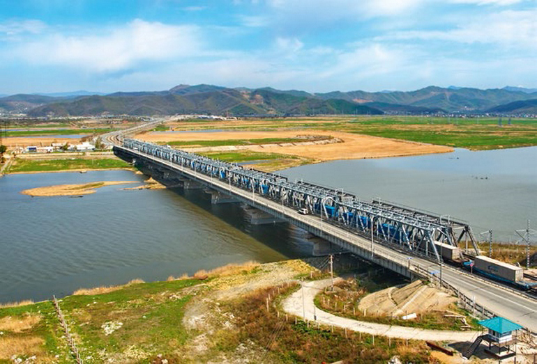
Road development plan
The strategic plan for the development of this road provides for a significant increase in the amount of allocations to the amount of 400000000000 rubles. These investments will make it possible to put into operation heavy trains. New railway tracks with a total length of seven thousand kilometers will appear. We are talking about routes: from the Elginskoye field to Ulak station, as well as from Fevralsk towards Gari and further to Shimanovskaya station. From Chyna to Novaya Chara, from Apsatskaya to Novaya Chara, from Olekminsk to Khanya and from Lensk to Nepa and further to Lena.
After completing a large volume of reconstruction work, the capacity of the Trans-Siberian Railway in the direction of the BAM will significantly increase. A number of experts propose to specialize the Trans-Siberian line to a greater extent in container and passenger transportation. It is expected that in the near future, BAM will be able to provide annual cargo transportation in the amount of fifty million tons.
On July 09, 2014, on the section of the Lodya - Taksimo section, in a solemn atmosphere on the occasion of the celebration of the anniversary date - the fortieth anniversary of the start of construction of the BAM, a “silver” link was laid.
December 2013 marked the beginning of new design and survey work on the track section between Khani and Tynda, which was headed by specialists from Chelyabzheldorproekt, which is a branch of Roszheldorproekt OJSC. The implementation of this project involves the construction of eleven new units of railway sidings: Ivanokita, Medvezhye, Mostovoy, Studenchesky, Zayachy, Sosnovy, Glukhariny, Mokhovy and other station points. This named area has the highest load compared to other areas. Therefore, new second branches of tracks with a total length of one hundred kilometers will appear here within three years.
At the beginning of 2015, during one day, two thousand cars passed through the Tynda station. Upon completion of the reconstruction, it is planned that the value of this indicator will be tripled. During the construction of the second tracks, it was planned to use rail sleeper grids with a reinforced concrete base.
With the onset of 2014, new second railway tracks were laid on the existing embankment. Some sections of the embankment were used as a road, so during the construction of the railway, the embankment was corrected. The presence of subsidence occurred due to climatic conditions, the reason for this is the presence of permafrost. All detected drawdowns have been eliminated. At the same time, the restoration of the former rotation camps is underway. The energy supply system, all signaling devices for communication, blocking and centralization are also subject to deep reconstruction. All new sidings will have seamless tracks and will be additionally equipped with turnouts, with a pneumatic blowing system operating on compressed air.
Assessments of the project for the construction of the Baikal-Amur Mainline are given differently, sometimes diametrically opposed. Some cite statements about the high cost, scale and romance, linking the latter factor with beautiful and amazing nature. At the same time, calling the creation of all these railway lines a pointless exercise, since the main question: “Why was this road built?” remained in the air, left unanswered. Modern prices for rail transportation already take into account all costs that will cover the amount of losses incurred. There is no talk of profits yet.
Other pundits express their thoughts of the opposite order. Despite the absence of such an indicator as profitability, BAM became the impetus that made it possible to develop local production. Without the presence of such a railway line, it would be simply impossible to develop anything in this region. Given the large size of our country, we must not forget the significance of the geopolitical role of the road.
The current President of the Russian Federation, Vladimir Putin, stated the fact that the created road is a necessary and necessary infrastructure, which will certainly receive further development in the future. One should not discount the importance of the road in the national economy and in the military-strategic one. Today's resources of the BAM are already beginning to be insufficient for the needs of the national economy. That is why modernization of the entire Baikal road was needed.
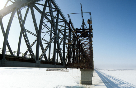
As for the presence of interesting facts, they are there, but it depends on what counts as an interesting event. It is no secret to anyone today that during the construction of the BAM, construction troops in the amount of two corps belonging to the armed forces of the Soviet Union were used for their intended purpose.
The construction of the road solved the transport problem of duplicating the Trans-Siberian Railway. This was especially felt during the period of tense relations with the People's Republic of China. One of the asteroids is named after the abbreviation of the same name for the road. The discovery of this asteroid took place at the Crimean Observatory on October 8, 1969 by astronomer Lyudmila Chernykh.
There are also incidental cases regarding knowledge of the Russian language, since the phrase: “Baikal-Amur Mainline”, based on the main word “magistral”, refers to the feminine gender, but the used abbreviation “BAM” should be classified as masculine.
For the needs of BAM, in 1976, ten thousand onboard trucks and dump trucks of the Magirus-Deutz brand with an air-cooled diesel engine were supplied from Germany. In fairness, it should be noted that a number of cars continue to work fully on the roads of the Far East today. And in those distant seventies, these cars were considered comfortable and prestigious, compared to our domestic trucks. Other foreign equipment also worked on the construction of this highway.
There are also many sad pages associated with the use of prison labor in heavy construction work. At that time this was common practice on a national scale. Well, in those days there was no need to be surprised when meeting the famous writer Anastasia Tsvetaeva, who was related to the poetess Marina Tsvetaeva, or the philosopher and engineer Pavel Florensky, at the construction of the BAM.
Baikal-Amur Mainline (BAM)
The Baikal-Amur Mainline (BAM) runs through the territory of the Irkutsk Region, Trans-Baikal Territory, Amur Region, the Republics of Buryatia and Sakha (Yakutia), and Khabarovsk Territory.
Key stations of the BAM: Taishet; Lena; Taximo; Tynda; Neryunga; New Urgal; Komsomolsk-on-Amur; Vanino; Sovetskaya Gavan.
The total length of the BAM from Taishet to Sovetskaya Gavan is 4,300 km. BAM is connected to the Trans-Siberian Railway by three connecting lines: Bamovskaya - Tynda, Izvestkovaya - Novy Urgal and Volochaevka - Komsomolsk-on-Amur.
Currently, a double-track railway has been built from Taishet to Lena (704 km) and a single-track railway from Lena to Taksimo (725 km). On the remaining section of the BAM, a single-track railway with diesel traction was built.
The BAM passes through an area with harsh natural and climatic conditions - through areas of permafrost (the depth of which is from 1-3 to hundreds of meters) and high seismicity (up to 9 points). The highway crosses 11 full-flowing rivers (among them the Lena, Amur, Zeya, Vitim, Olekma, Selemdzha, Bureya) and 7 mountain ranges (Baikalsky, Severo-Muysky, Udokansky, Kodarsky, Olekminsky Stanovik, Turansky and Dusse-Alinsky). Due to the difficult terrain, more than 30 km of the railway passes through tunnels (among them Baikalsky (6.7 km) and Severo-Muysky (15.3 km)).
During the construction of BAM, the latest designs were used, new methods for constructing and operating facilities in difficult hydrogeological conditions were developed and patented.
"History of the construction of BAM"
The prerequisites for the start of construction of the Baikal-Amur Mainline were the disappointing results of the Russian-Japanese War of 1904-1905, which showed the urgent need for the construction of a second railway in the east of the country, duplicating the Trans-Siberian Railway.
According to the original plan, the highway was supposed to run from Ufa along the shortest distance to the eastern sea coast through the northern tip of Lake Baikal.
During Soviet times, research to develop a railway network in the east of the country resumed in the late 1920s. - early 30s It was then that the road from Taishet to the east first received its modern name - the Baikal-Amur Mainline. It was proposed to start the road from Urusha station (approximately the middle of the current BAM in the Skovorodina area), and the final destination was planned to be Komsomolsk-on-Amur, which was then the village of Perm.
In 1932, the Council of People's Commissars adopted a resolution "On the construction of the Baikal-Amur Mainline", which approved the construction plan for the BAM. Construction was planned to be completed in 3 years: through traffic along the entire highway in operational mode was to be opened by the end of 1935.
However, the construction of the highway was repeatedly stopped for various reasons (lack of labor, the Great Patriotic War, earthquakes in the construction area in the late 1950s).
Active construction of the BAM was resumed in 1974. The main drivers of construction were Komsomol volunteers and military builders. Republican Komsomol detachments competed with each other and had “their own” objects: the largest Urgal station was built by the Ukrainian SSR, Muyakan station - Belarus, Uoyan - Lithuania, Kichera - Estonia, Tayura - Armenia, Ulkan - Azerbaijan, Soloni - Tajikistan, Alonku - Moldova. Tynda, the capital of BAM, was built by Muscovites.
By 1980, the Baikal-Amur Railway was organized with the railway administration located in the city of Tynda.
On September 29, 1984, the “golden” docking took place at the Balbukhta junction (Kalarsky district, Chita region). The eastern and western directions of the BAM builders met, moving towards each other for 10 years. On October 1, the laying of the “golden” links of the BAM took place at Kuanda station (Kalarsky district, Chita region).
The final completion of the construction of the Baikal-Amur Mainline can be considered December 5, 2003, when traffic through the Severo-Muysky tunnel was opened. In terms of its length (15,343 m), it is the longest tunnel in Russia and the fifth in the world. According to the construction conditions, the tunnel has no analogues: permafrost, abundance of groundwater, scree, landslides, tectonic faults.
BAM now. The construction of the BAM solved problems at the national level: access to the natural resources of a huge region was opened; transit transportation is provided; the shortest intercontinental East-West railway route was created, running for 10,000 km along Russian railways; in a military-strategic sense, the highway counters possible disruptions and interruptions in the movement of trains on the Trans-Siberian Railway. Currently, the socio-economic potential of BAM has not been fully realized. The operation of this highway does not bring profit to JSC Russian Railways. The main reason for the current situation is the slow development of adjacent territories. Of the planned nine territorial production complexes that were supposed to ensure the loading of the BAM, only one was implemented - in the Neryungri coal basin.
In the direction Taishet - Tynda - Komsomolsk-on-Amur, the volume of freight traffic is about 12 million tons per year. The limitation of the capacity of sections of the BAM is caused by the closure of separate points during the period of decline in transportation in the 90s, the presence of sections where the time between repairs was violated, there are defects in the roadbed, the upper structure of the track and artificial structures.
BAM carries about 12 million passengers a year. The intensity of passenger train traffic along the mainline is insignificant - 1-2 pairs of trains per day on the Komsomolsk-Severobaykalsk section and 9-16 pairs on the western section.
BAIKAL-AMUR MAIN (BAM) is a railway route in Eastern Siberia and the Far East, the second main railway exit to. It runs through the northern regions of the Irkutsk region (pre-Baikal section), Buryat ACCP, Chita region (trans-Baikal section), Amur region and Khabarovsk Territory (Far Eastern section). The total length of the route from Taishet to Sovetskaya Gavan is 4,300 km, of which the Ust-Kut (on the Lena) - Komsomolsk-on-Amur section, which has been under construction since 1974, is 3,100 km; it is adjacent to two previously built sections: Taishet - Ust-Kut (733 km, commissioned in 1958) and Komsomolsk-on-Amur - Sovetskaya Gavan (434 km, commissioned in 1947). Three connecting lines connect the BAM with the Trans-Siberian Railway: BAM - Tynda, Izvestkovaya - Urgal and Volochaevka - Komsomolsk-on-Amur. The territory included in the zone of influence of the BAM (about 1.5 million km 2) is distinguished by very complex natural conditions, geological structure and relief, development, strong, significant swampiness, which determine a large volume of geological research, engineering-geological and hydrogeological surveys related to the construction of routes, construction of station and other villages and cities, development of mineral resources.
Relief. The Pre-Baikal area occupies the Prilenskoye (Angaro-Lenskoye) plateau with a predominance of soft forms - wide flat, small depressions and plains. vary between 400-1000 m. The route is laid mainly along the valleys of the Lena, Tayura, Kirenga, Kunerma rivers. The Trans-Baikal section is entirely located within the Baikal mountainous country. In its western part there are the Baikal, Akitkan, Synnyr and Barguzin ridges with heights of up to 2600 m. The Baikal ridge is characterized by alpine relief forms - trough valleys, karras, cirques and rocky placers (kurums) and others; The ridges have features of alpine plateaus. The eastern part is occupied by the vast and complexly constructed Stanovoye Highlands, where high ridges and deep basins stretching from the west - southwest to the east - northeast alternate. The latter divide this highland into two chains: the northern, which includes the Verkhneangarsky, Delyun-Uransky, Severo-Muysky, Muyakansky and Kodarsky ridges, the southern - the South Muysky, Kalarsky and Udokansky ridges. Absolute heights reach 2800 m (Skalisty char in the Kalarsky ridge).
All ridges represent systems of dome-shaped or flat-topped char, covered with coarse sediments; in the axial parts of the ridges there are alpine landforms; There are traces of ancient and, in the Kodar ridge, modern glaciation (circuses, karras, moraine ridges, glacial lakes). Most of the route in this section crosses the largest basins - Verkhneangarskaya, Muisko-Kuandinskaya and Verkhnecharskaya, which have absolute heights of 500-700 m and hilly-flat terrain. The Trans-Baikal section includes all of the BAM, the total length of which is 26 km, including Severo-Muysky 15.3 km, Baikalsky 6.7 km. The Far Eastern section combines mid- and low-altitude mountains with extensive accumulative-denudation plains. The route runs here along the southern spurs of the Stanovoy Range, crosses the Tukuringra-Dzhagdy, Turan, Bureinsky, Dusse-Alinsky, Badzhalsky, Sikhote-Alin ridges and goes to the coast. Approximately 1/3 of the Far Eastern section of the route runs along the Verkhnezeyskaya and Amur-Zeysko-Bureinskaya plains, which have a ridged and heavily swampy topography. In mountainous regions it passes mainly along mountain slopes and river valleys (left tributaries of the Amur).
Geological structure. The territory adjacent to the BAM covers fragments of several major tectonic structures - the Baikal and Stanovoy mountain regions, the Mongol-Okhotsk and Sikhote-Alin fold systems (see map). These structures are limited by thick, extended fault zones; Numerous faults determine their mosaic block structure. The long and complex history of geological development predetermined the wide distribution of sedimentary, volcanogenic, intrusive, metasomatic and metamorphic complexes of extremely diverse composition, as well as those associated with them, of different ages (from to). The western part (the basins of the Angara, Lower Tunguska, and upper Lena rivers) belongs to the southeastern edge of the Siberian Platform. Gentle-lying carbonate-terrigenous and saturated deposits are developed here. In the Western Baikal region, the thickness of Paleozoic and underlying Proterozoic sediments increases sharply, as does the degree of their dislocation (Angaro-Lena trough).
In the Baikal mountainous country, metamorphosed and dislocated sedimentary and volcanogenic strata of the Upper Archean, Proterozoic and Lower Paleozoic, penetrated by intrusions of various compositions, are widespread. There are outcrops of the most ancient crystalline basement (Baikal, North Muya blocks, etc.). Mesozoic sedimentary, volcanic and intrusive formations are observed in places. Large depressions of the Baikal type are filled with a thickness of loose Cenozoic sediments (see). Metamorphic strata of the Lower Archean are developed within, among which numerous suture troughs () with greenstone sedimentary-volcanogenic-siliceous formations are mapped. In the Kodaro-Udokan region they are covered by a thick layer of Lower Proterozoic, and in the basins of the Zhuya, Aldan, Uchur rivers - by gently lying terrigenous and carbonate sediments, and. Along the southern margin of the shield stretches a series of depressions with Jurassic and Cretaceous coal-bearing deposits (Chulmanskaya, Tokyo, etc.). Intrusive formations include ancient gabbro- and hyperbasites, Paleozoic granitoids, Mesozoic small alkaline compositions, Proterozoic alkaline intrusions. The Stanova mountain region is characterized by a wide distribution of Archean metamorphic rocks and granite-gneisses, Mesozoic granitoids. There are troughs with Precambrian greenstone complexes. Disconnected Mesozoic volcanic structures, small intrusions of various compositions, as well as those made of coal-bearing Jurassic and Cretaceous deposits are found everywhere.
In the Mongol-Okhotsk folded system, metamorphosed and dislocated sedimentary and volcanogenic strata of the Proterozoic, Paleozoic and Mesozoic, intruded by intrusions of different ages, are developed. In the basin of the Zeya and its tributaries, Mesozoic volcanic structures and depressions filled with coal-bearing deposits are known. Within the Bureya massif, ancient granitoids predominate, cutting through Precambrian ones. In the east of the region, sedimentary-volcanogenic formations of the Mesozoic and Paleozoic are developed, composing the Sikhote-Alin fold system. There are very numerous volcanic buildings and belts (Primorsky, Yam-Alinsky), in the structure of which Mesozoic and Paleogene-Early Quaternary volcanic rocks take part. Late Mesozoic granitoids predominate among the intrusive formations. A series of large rift depressions and extensive troughs are formed by Cenozoic sediments (Tugur graben, Khabarovsk depression, etc.).
Seismicity. Part of the BAM zone is highly seismic. The pre-Baikal section, which runs along the Siberian platform, is practically aseismic, but “transit” earthquakes of up to 5 magnitude from the Baikal seismic belt sometimes occur here. The Transbaikal area is the most seismic. It has been established that the epicenters are grouped into a relatively narrow strip along the chain of rift basins; At the same time, inter-rift mountain bridges (Verkhneangarsko-Muyskaya, Muysko-Chara) are characterized by increased seismicity. The seismic situation in the Far Eastern area is very different. Increased seismicity to the East of the Udokan Range and in the area of the middle reaches of the Olekma River is associated with the system of ruptures of the Stanovoi Fault. To the East of the Olekma River, seismicity weakens, but in the area of the Tukuringra-Dzhagdy ridge it increases again; it is connected with the Mongol-Okhotsk fault. Further to the East, earthquakes occur less frequently and of lesser strength, however, here too there are seismic sources (Zeysky, Amgunsky, etc.) with earthquake strengths of up to 7 points. Thus, the BAM zone is located in difficult engineering and seismological conditions; When designing structures, anti-seismic reinforcement of structures is provided.
Permafrost. The westernmost section belongs to the non-frozen zone; in the rest of the territory it is distributed either in the form of islands or everywhere. To the East from the Angara to the Baikal ridge, permafrost occupies small areas and occurs in the form of separate massifs in swampy river valleys and on the northern slopes. In large rift depressions of the Baikal mountain region, permafrost is developed only on floodplains and the first terraces of rivers, on deluvial plumes and alluvial cones, which are usually swampy. The thickness of permafrost can apparently reach values from 150 to 500-600 m. In the mountain frame of depressions with ridge heights of 2000-2800 m, the most severe permafrost conditions exist. Permafrost strata are characterized by an almost continuous distribution, interrupted only at the bottoms of deeply incised large valleys and flooded zones. Their thickness apparently reaches more than 1 km. On the Aldan Shield, the continuity and thickness of permafrost increases with height. The mildest permafrost conditions exist in the altitude range of 800-1000 m, where watersheds are usually thawed. Such watersheds are developed mainly within Mesozoic coal-bearing depressions. Below, the permafrost again becomes predominantly continuous, interrupted by taliks only in the valleys of large rivers.
The watershed spaces of the highest ridges (Stanovoy, Yankan, Tukuringra), as a rule, are frozen, the thickness of the permafrost reaches 200 m. On the southern slopes and on low (500-1000 m) watersheds, the thickness of permafrost rocks is sharply reduced, taliks are widely developed; swampy valley bottoms and deluvial plumes at the foot of the slopes are permafrost. In the mid-mountain ridges of the Amur region (Soktakhan, Dzhagdy, Ezop, Dusse-Alin, Bureinsky, etc.), the structural patterns of cryolithosis are similar. The permafrost conditions of intermountain depressions are more differentiated. In the northernmost of them, Verkhnezeiskaya, permafrost rocks have an almost continuous distribution. Within the Zee-Bureya Plain, they line the bottoms of wide swampy valleys, measured ridges, and watersheds composed of finely dispersed sediments on the surface.
Depending on natural conditions, there are large differences in the conditions for the formation of resources and the composition of groundwater. In the platform conditions of the Angara-Lena Plateau, formation and formation-karst waters predominate in terrigenous-carbonate rocks of the Ordovician and Lower Cambrian, and to a lesser extent in alluvial and glacial deposits. Large centers of groundwater discharge sometimes form in areas of contact between highly permeable carbonate rocks and weakly permeable terrigenous rocks, forming lithological barriers. In the Baikal mountainous country, significant groundwater resources are concentrated in alluvial and lacustrine-alluvial deposits, in massifs of carbonate rocks in fault zones (talik waters). On the Aldan Shield and in the Stanovoy Range, groundwater is also associated mainly with continuous taliks in alluvial deposits; There are fissure sub-permafrost and fissure-vein waters in fault zones. In the Zeya and Zeya-Bureya depressions, abundant horizons of pressure water (often sub-permafrost) are associated with Jurassic and Cretaceous sandstones and lacustrine-alluvial deposits. In the Bureinsky ridge and the Sikhote-Alin region there are significant accumulations of formation and fissure waters; The groundwater of river valleys is most suitable for practical use.
Permafrost rocks are important for the formation of hydrogeological conditions in most of the territory of the BAM zone. In some cases, they exclude huge massifs from active water exchange, in others they serve as a regional aquitard, separating waters into sub-permafrost and supra-permafrost. The groundwater of the zone is extremely diverse in chemical composition, which is determined by the chemical composition of the water-bearing rocks. The degree of water mineralization also varies within very wide limits (from 0.1 to 630 g/l). There are quite numerous sources of mineral waters. The East Siberian hydromineral region of nitrogen and methane chloride and sulfate salt waters and brines, the Baikal region of nitrogen and methane thermal waters, the Lower Amur region of cold carbon dioxide waters, and the Amur-Primorsky region of nitrogen and methane thermal waters are distinguished. Mineral waters can be used here for medicinal, thermoenergetic, industrial purposes, as a source of extraction of table salt, etc.
Engineering-geological conditions. The most general feature of the engineering-geological structure of the zone is the predominant development of rocks, overlain by an insignificant cover of loose Quaternary sediments of eluvial, deluvial, alluvial and glacial origin. The thickness of this cover is 2-3 m, in rare cases more than 10-15 m. This thickness is an object of engineering-geological development; it contains overdeepened valleys, includes some fields of development of glacial and water-glacial deposits, and large deluvial plumes. A significantly smaller area is occupied by areas where the entire engineering-geological section is composed of loose Cenozoic sediments. These are the rift depressions of the Baikal region and large depressions of the Amur region.
The most important factor in the formation of geotechnical engineering. conditions - modern geological processes and phenomena. In the BAM zone, slope processes (deluvial washout, solifluction, and especially stone rivers) are widespread, which pose a particular danger during above-ground construction. Avalanches, mudflows and associated forms (foci, chutes, plumes) are widespread on alpine ridges. The BAM zone is covered by underground and ice dams of various sizes and dynamics. A significant part of the aufeis has developed well-defined aufeis glades. Cryogenic phenomena such as thermokarst, polygonal formations (re-veined ice, ground veins, etc.), structural soils (stone rings, medallion spots, etc.), associated mainly with valley bottoms, wide watershed spaces, are widespread. plains. In general, the conditions for engineering development of the BAM zone are difficult, especially within the Baikal folded region, where high seismicity, the most severe permafrost and high mountainous terrain are combined.
In the Stanovoy region, gold mining is of industrial importance; ore occurrences of molybdenum, cuprous sandstones, polymetallic ores, rare elements, apatite, magnetite ores, ornamental stones, and building materials have been identified. The Mongol-Okhotsk system and the Bureya massif are characterized by numerous placers and small deposits of gold ore, iron (Garinskoye), coal (Bureya coal basin), occurrences of tin-polymetallic ores, molybdenum, and phosphorites. In the Sikhote-Alin system, the leading role belongs to mining (Komsomolsky, Badzhalsky and other areas); deposits of gold and tungsten ores are also known.
Neogene-Quaternary depressions contain hard and brown coals (Lianskoye deposit). In all areas of the BAM development zone there are numerous deposits of various building materials, the reserves of which support the construction of the route itself, industrial and residential facilities.
The development of mineral resources, along with logging, will give impetus to the development of the productive forces of the BAM zone. Large reserves of valuable minerals contribute to the formation of territorial production complexes on their basis, such as in Southern Yakutia, where large-scale coal mining is developing, and in the future the extraction of iron ores, apatite, etc. is possible.